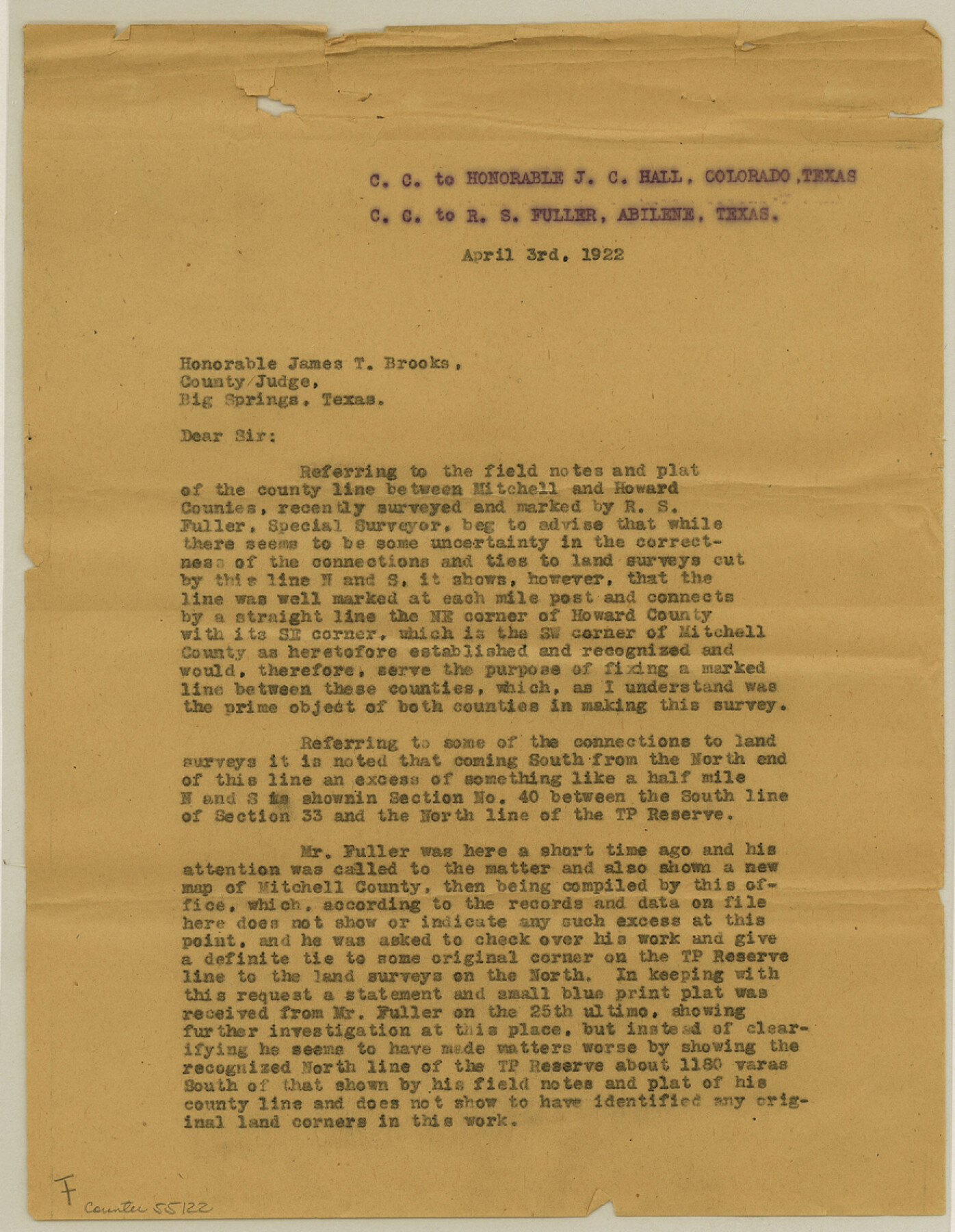
Howard County Boundary File 2b
[Letter regarding Howard-Mitchell Boundary line]
-
Map/Doc
55122
-
Collection
General Map Collection
-
Counties
Howard
-
Subjects
County Boundaries
-
Height x Width
11.4 x 8.8 inches
29.0 x 22.4 cm
Part of: General Map Collection
Texas 1973 Official Highway Travel Map

Texas 1973 Official Highway Travel Map
Size 28.1 x 36.3 inches
Map/Doc 94406
Culberson County Rolled Sketch 52

Print $20.00
- Digital $50.00
Culberson County Rolled Sketch 52
Size 19.1 x 24.7 inches
Map/Doc 5672

Caldwell County Sketch File 2

Print $40.00
- Digital $50.00
Caldwell County Sketch File 2
1877
Size 12.9 x 20.0 inches
Map/Doc 11030
Harris County Sketch File 68

Print $20.00
- Digital $50.00
Harris County Sketch File 68
1939
Size 22.9 x 10.6 inches
Map/Doc 11662
Hidalgo County Working Sketch 1

Print $20.00
- Digital $50.00
Hidalgo County Working Sketch 1
1939
Size 24.8 x 21.4 inches
Map/Doc 66178
Flight Mission No. CLL-1N, Frame 8, Willacy County

Print $20.00
- Digital $50.00
Flight Mission No. CLL-1N, Frame 8, Willacy County
1954
Size 18.3 x 22.1 inches
Map/Doc 86995
Terrell County Working Sketch 53

Print $20.00
- Digital $50.00
Terrell County Working Sketch 53
Size 13.5 x 17.8 inches
Map/Doc 69802

Flight Mission No. DQO-3K, Frame 28, Galveston County

Print $20.00
- Digital $50.00
Flight Mission No. DQO-3K, Frame 28, Galveston County
1952
Size 18.1 x 22.3 inches
Map/Doc 85069
Flight Mission No. CRC-1R, Frame 36, Chambers County

Print $20.00
- Digital $50.00
Flight Mission No. CRC-1R, Frame 36, Chambers County
1956
Size 18.7 x 22.3 inches
Map/Doc 84704
Starr County Rolled Sketch 34

Print $20.00
- Digital $50.00
Starr County Rolled Sketch 34
1945
Size 20.8 x 17.9 inches
Map/Doc 7831
You may also like
Little River, Faubion Bridge Sheet

Print $4.00
- Digital $50.00
Little River, Faubion Bridge Sheet
1914
Size 19.0 x 27.8 inches
Map/Doc 65060
Map of Maryland, Virginia, North Carolina and South Carolina

Print $20.00
- Digital $50.00
Map of Maryland, Virginia, North Carolina and South Carolina
1885
Size 12.2 x 9.0 inches
Map/Doc 93517
Titus County Working Sketch 6

Print $40.00
- Digital $50.00
Titus County Working Sketch 6
1962
Size 29.8 x 55.5 inches
Map/Doc 69367
Gaines County Working Sketch 8

Print $20.00
- Digital $50.00
Gaines County Working Sketch 8
1951
Size 21.8 x 24.8 inches
Map/Doc 69308
[Surveys near Seco Creek]
![225, [Surveys near Seco Creek], General Map Collection](https://historictexasmaps.com/wmedia_w700/maps/225.tif.jpg)
Print $2.00
- Digital $50.00
[Surveys near Seco Creek]
1846
Size 13.1 x 7.3 inches
Map/Doc 225
Gonzales County Working Sketch 2

Print $20.00
- Digital $50.00
Gonzales County Working Sketch 2
1920
Size 17.6 x 21.5 inches
Map/Doc 63217
Brooks County Working Sketch 13

Print $20.00
- Digital $50.00
Brooks County Working Sketch 13
1943
Size 22.4 x 31.9 inches
Map/Doc 67797
Edwards County Working Sketch Graphic Index - east part - sheet 2

Print $40.00
- Digital $50.00
Edwards County Working Sketch Graphic Index - east part - sheet 2
1975
Size 54.7 x 39.8 inches
Map/Doc 76534
Real County Working Sketch 75

Print $20.00
- Digital $50.00
Real County Working Sketch 75
1979
Size 29.0 x 28.6 inches
Map/Doc 71967
Chambers County Working Sketch 8

Print $20.00
- Digital $50.00
Chambers County Working Sketch 8
1940
Size 20.9 x 44.4 inches
Map/Doc 67991
General Highway Map, Shackelford County, Texas

Print $20.00
General Highway Map, Shackelford County, Texas
1961
Size 18.1 x 24.8 inches
Map/Doc 79651
Presidio County Rolled Sketch 93A

Print $20.00
- Digital $50.00
Presidio County Rolled Sketch 93A
Size 29.6 x 28.2 inches
Map/Doc 7379