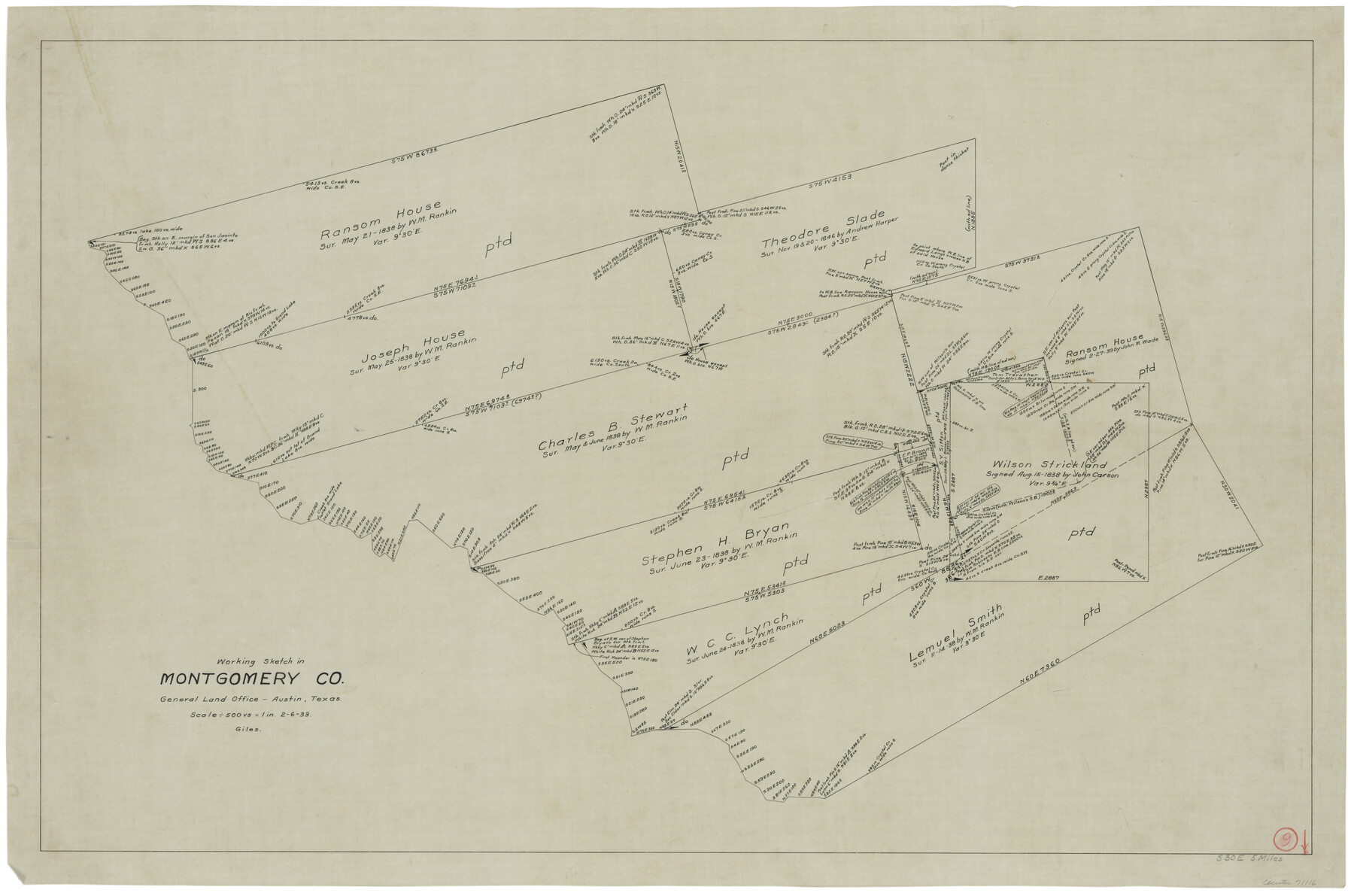
Montgomery County Working Sketch 9
-
Map/Doc
71116
-
Collection
General Map Collection
-
Object Dates
2/6/1933 (Creation Date)
-
People and Organizations
J. Bascom Giles (Draftsman)
-
Counties
Montgomery
-
Subjects
Surveying Working Sketch
-
Height x Width
26.4 x 39.6 inches
67.1 x 100.6 cm
-
Scale
1" = 500 varas
Part of: General Map Collection
Flight Mission No. BRA-6M, Frame 145, Jefferson County

Print $20.00
- Digital $50.00
Flight Mission No. BRA-6M, Frame 145, Jefferson County
1953
Size 18.4 x 22.4 inches
Map/Doc 85446
Madison County Working Sketch 15

Print $20.00
- Digital $50.00
Madison County Working Sketch 15
2009
Size 42.3 x 36.0 inches
Map/Doc 89019
Baylor County

Print $20.00
- Digital $50.00
Baylor County
1961
Size 40.6 x 33.0 inches
Map/Doc 77209
Kaufman County Sketch File 19

Print $30.00
- Digital $50.00
Kaufman County Sketch File 19
1922
Size 11.2 x 8.7 inches
Map/Doc 28666
[Gulf, Colorado & Santa Fe Railway line through Fort Bend Co.]
![64212, [Gulf, Colorado & Santa Fe Railway line through Fort Bend Co.], General Map Collection](https://historictexasmaps.com/wmedia_w700/maps/64212.tif.jpg)
Print $20.00
- Digital $50.00
[Gulf, Colorado & Santa Fe Railway line through Fort Bend Co.]
1898
Size 14.2 x 33.5 inches
Map/Doc 64212
Aransas County Sketch File 29

Print $24.00
- Digital $50.00
Aransas County Sketch File 29
Size 7.8 x 8.1 inches
Map/Doc 13234
Wilson County Sketch File 3

Print $6.00
- Digital $50.00
Wilson County Sketch File 3
1848
Size 13.3 x 8.6 inches
Map/Doc 40399

Duval County Boundary File 3d

Print $8.00
- Digital $50.00
Duval County Boundary File 3d
Size 14.2 x 8.8 inches
Map/Doc 52738
Freestone County

Print $40.00
- Digital $50.00
Freestone County
1918
Size 48.4 x 41.6 inches
Map/Doc 66830
Flight Mission No. DQN-2K, Frame 137, Calhoun County

Print $20.00
- Digital $50.00
Flight Mission No. DQN-2K, Frame 137, Calhoun County
1953
Size 18.8 x 22.5 inches
Map/Doc 84306
Culberson County Rolled Sketch 38
Print $20.00
- Digital $50.00
Culberson County Rolled Sketch 38
1938
Size 29.5 x 38.8 inches
Map/Doc 5661
You may also like
Tyler County Sketch File 28

Print $46.00
- Digital $50.00
Tyler County Sketch File 28
1960
Size 9.8 x 8.6 inches
Map/Doc 38699
Grayson County Working Sketch 21

Print $20.00
- Digital $50.00
Grayson County Working Sketch 21
1961
Size 42.6 x 26.5 inches
Map/Doc 63260
San Augustine County Working Sketch 2

Print $20.00
- Digital $50.00
San Augustine County Working Sketch 2
Size 28.5 x 19.1 inches
Map/Doc 63689
Castro County Sketch File 9

Print $4.00
- Digital $50.00
Castro County Sketch File 9
1908
Size 11.2 x 8.6 inches
Map/Doc 17499
Jeff Davis County Working Sketch 19

Print $40.00
- Digital $50.00
Jeff Davis County Working Sketch 19
1957
Size 71.3 x 34.1 inches
Map/Doc 66514
Amplissimae Regionis Mississipi seu Provinciae Ludovicianae a R.P. Ludovico Hennepin Francisc Miss in America Septentrionali Anno 1687. Detectae, Nunc Gallorum Coloniis et Actionum Negotiis Toto Orbe Celeberrimae

Print $20.00
- Digital $50.00
Amplissimae Regionis Mississipi seu Provinciae Ludovicianae a R.P. Ludovico Hennepin Francisc Miss in America Septentrionali Anno 1687. Detectae, Nunc Gallorum Coloniis et Actionum Negotiis Toto Orbe Celeberrimae
1720
Size 20.7 x 24.2 inches
Map/Doc 97516
Military Reconnaissance [showing forts along Rio Grande near Matamoros]
![72911, Military Reconnaissance [showing forts along Rio Grande near Matamoros], General Map Collection](https://historictexasmaps.com/wmedia_w700/maps/72911.tif.jpg)
Print $20.00
- Digital $50.00
Military Reconnaissance [showing forts along Rio Grande near Matamoros]
1846
Size 18.2 x 27.2 inches
Map/Doc 72911
Rusk County Working Sketch 21

Print $20.00
- Digital $50.00
Rusk County Working Sketch 21
1953
Size 27.6 x 28.3 inches
Map/Doc 63657
Guadalupe County Sketch File 15a

Print $9.00
- Digital $50.00
Guadalupe County Sketch File 15a
Size 10.3 x 8.2 inches
Map/Doc 24687
Kinney County Working Sketch 32

Print $20.00
- Digital $50.00
Kinney County Working Sketch 32
1961
Size 32.6 x 42.5 inches
Map/Doc 70214
Survey of Mustang Is., Joseph's and a part of Matagorda Island.

Print $20.00
- Digital $50.00
Survey of Mustang Is., Joseph's and a part of Matagorda Island.
1834
Size 19.5 x 20.2 inches
Map/Doc 3183
Jackson County Sketch File 21

Print $70.00
- Digital $50.00
Jackson County Sketch File 21
2000
Size 11.3 x 8.8 inches
Map/Doc 27673