Land grants from the state of Tamaulipas in the trans-Nueces

Land grants from the state of Tamaulipas in the trans-Nueces
2009
Size: 11.0 x 8.5 inches
94040
Kenedy County Sketch File 3

Print $22.00
- Digital $50.00
Kenedy County Sketch File 3
2003
Size: 11.0 x 8.5 inches
82452
Kenedy County Sketch File 2

Print $130.00
- Digital $50.00
Kenedy County Sketch File 2
1995
Size: 11.2 x 8.7 inches
28773
Kenedy County Rolled Sketch 18

Print $20.00
- Digital $50.00
Kenedy County Rolled Sketch 18
1995
Size: 29.5 x 39.2 inches
6472
Aransas Pass to Baffin Bay

Print $20.00
- Digital $50.00
Aransas Pass to Baffin Bay
1992
Size: 45.0 x 36.0 inches
73423
Northern Part of Laguna Madre

Print $20.00
- Digital $50.00
Northern Part of Laguna Madre
1992
Size: 45.4 x 35.3 inches
73532
Aransas Pass to Baffin Bay

Print $40.00
- Digital $50.00
Aransas Pass to Baffin Bay
1988
Size: 48.7 x 36.0 inches
73422
Northern Part of Laguna Madre

Print $20.00
- Digital $50.00
Northern Part of Laguna Madre
1988
Size: 45.1 x 36.4 inches
73531
Aransas Pass to Baffin Bay

Print $20.00
- Digital $50.00
Aransas Pass to Baffin Bay
1986
Size: 44.7 x 35.7 inches
73421
Northern Part of Laguna Madre

Print $20.00
- Digital $50.00
Northern Part of Laguna Madre
1982
Size: 44.2 x 35.0 inches
73530
Aransas Pass to Baffin Bay

Print $20.00
- Digital $50.00
Aransas Pass to Baffin Bay
1981
Size: 43.0 x 35.0 inches
73420
Kenedy County Working Sketch Graphic Index

Print $20.00
- Digital $50.00
Kenedy County Working Sketch Graphic Index
1978
Size: 46.6 x 35.8 inches
76603
Kenedy County Rolled Sketch 16

Print $40.00
- Digital $50.00
Kenedy County Rolled Sketch 16
1978
Size: 36.7 x 50.2 inches
10693
Aransas Pass to Baffin Bay

Print $20.00
- Digital $50.00
Aransas Pass to Baffin Bay
1976
Size: 41.9 x 35.3 inches
73419
Intracoastal Waterway - Laguna Madre - Chubby Island to Stover Point including the Arroyo Colorado, Texas

Print $20.00
- Digital $50.00
Intracoastal Waterway - Laguna Madre - Chubby Island to Stover Point including the Arroyo Colorado, Texas
1976
Size: 15.6 x 43.8 inches
75900
Intracoastal Waterway - Laguna Madre - Chubby Island to Stover Point including the Arroyo Colorado, Texas

Print $20.00
- Digital $50.00
Intracoastal Waterway - Laguna Madre - Chubby Island to Stover Point including the Arroyo Colorado, Texas
1976
Size: 16.0 x 43.9 inches
75901
Texas Gulf Coast, from the Sabine River to the Rio Grande as Subdivided for Mineral Development; Aransas, Nueces, Kleberg, Kenedy, Willacy, and Cameron Counties

Print $40.00
- Digital $50.00
Texas Gulf Coast, from the Sabine River to the Rio Grande as Subdivided for Mineral Development; Aransas, Nueces, Kleberg, Kenedy, Willacy, and Cameron Counties
1976
Size: 118.0 x 43.0 inches
1940
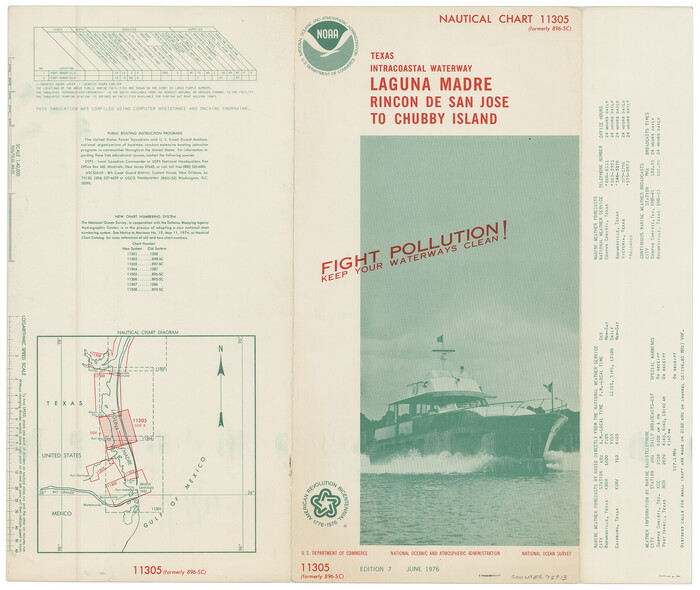
[Folder for] Nautical Chart 11305: Texas Intracoastal Waterway, Laguna Madre, Rincon de San Jose to Chubby Island
Print $20.00
- Digital $50.00
[Folder for] Nautical Chart 11305: Texas Intracoastal Waterway, Laguna Madre, Rincon de San Jose to Chubby Island
1976
Size: 16.0 x 19.0 inches
75913
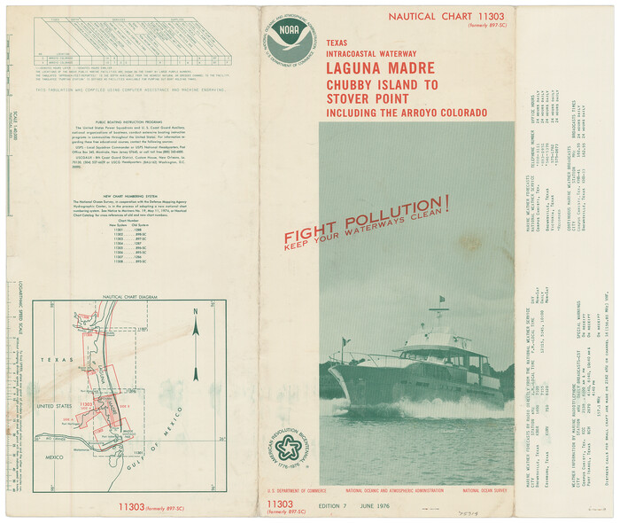
[Folder for] Nautical Chart 11303: Texas Intracoastal Waterway, Laguna Madre, Chubby Island to Stover Point including the Arroyo Colorado
Print $20.00
- Digital $50.00
[Folder for] Nautical Chart 11303: Texas Intracoastal Waterway, Laguna Madre, Chubby Island to Stover Point including the Arroyo Colorado
1976
Size: 15.9 x 18.8 inches
75914
Intracoastal Waterway - Laguna Madre - Rincon de San Jose to Chubby Island, Texas

Print $20.00
- Digital $50.00
Intracoastal Waterway - Laguna Madre - Rincon de San Jose to Chubby Island, Texas
1975
Size: 16.0 x 37.1 inches
73516
Intracoastal Waterway - Laguna Madre - Rincon de San Jose to Chubby Island, Texas

Print $20.00
- Digital $50.00
Intracoastal Waterway - Laguna Madre - Rincon de San Jose to Chubby Island, Texas
1975
Size: 15.6 x 37.0 inches
73517
Aransas Pass to Baffin Bay

Print $20.00
- Digital $50.00
Aransas Pass to Baffin Bay
1973
Size: 42.0 x 35.1 inches
73418
Plat of a survey on Padre Island in Willacy and Kenedy Counties surveyed for South Padre Development Corporation by Claunch and Associates

Print $20.00
- Digital $50.00
Plat of a survey on Padre Island in Willacy and Kenedy Counties surveyed for South Padre Development Corporation by Claunch and Associates
1973
Size: 46.5 x 41.6 inches
61424
Northern Part of Laguna Madre

Print $20.00
- Digital $50.00
Northern Part of Laguna Madre
1972
Size: 44.2 x 35.0 inches
73529
Aransas Pass to Baffin Bay

Print $20.00
- Digital $50.00
Aransas Pass to Baffin Bay
1971
Size: 42.3 x 35.2 inches
73417
Northern Part of Laguna Madre

Print $20.00
- Digital $50.00
Northern Part of Laguna Madre
1968
Size: 44.4 x 34.5 inches
73528
Aransas Pass to Baffin Bay

Print $20.00
- Digital $50.00
Aransas Pass to Baffin Bay
1966
Size: 42.3 x 35.0 inches
73415
Land grants from the state of Tamaulipas in the trans-Nueces
Land grants from the state of Tamaulipas in the trans-Nueces
2009
-
Size
11.0 x 8.5 inches
-
Map/Doc
94040
-
Creation Date
2009
Kenedy County Sketch File 3
Print $22.00
- Digital $50.00
Kenedy County Sketch File 3
2003
-
Size
11.0 x 8.5 inches
-
Map/Doc
82452
-
Creation Date
2003
Kenedy County Sketch File 2
Print $130.00
- Digital $50.00
Kenedy County Sketch File 2
1995
-
Size
11.2 x 8.7 inches
-
Map/Doc
28773
-
Creation Date
1995
Kenedy County Rolled Sketch 18
Print $20.00
- Digital $50.00
Kenedy County Rolled Sketch 18
1995
-
Size
29.5 x 39.2 inches
-
Map/Doc
6472
-
Creation Date
1995
Aransas Pass to Baffin Bay
Print $20.00
- Digital $50.00
Aransas Pass to Baffin Bay
1992
-
Size
45.0 x 36.0 inches
-
Map/Doc
73423
-
Creation Date
1992
Northern Part of Laguna Madre
Print $20.00
- Digital $50.00
Northern Part of Laguna Madre
1992
-
Size
45.4 x 35.3 inches
-
Map/Doc
73532
-
Creation Date
1992
Aransas Pass to Baffin Bay
Print $40.00
- Digital $50.00
Aransas Pass to Baffin Bay
1988
-
Size
48.7 x 36.0 inches
-
Map/Doc
73422
-
Creation Date
1988
Northern Part of Laguna Madre
Print $20.00
- Digital $50.00
Northern Part of Laguna Madre
1988
-
Size
45.1 x 36.4 inches
-
Map/Doc
73531
-
Creation Date
1988
Aransas Pass to Baffin Bay
Print $20.00
- Digital $50.00
Aransas Pass to Baffin Bay
1986
-
Size
44.7 x 35.7 inches
-
Map/Doc
73421
-
Creation Date
1986
Northern Part of Laguna Madre
Print $20.00
- Digital $50.00
Northern Part of Laguna Madre
1982
-
Size
44.2 x 35.0 inches
-
Map/Doc
73530
-
Creation Date
1982
Aransas Pass to Baffin Bay
Print $20.00
- Digital $50.00
Aransas Pass to Baffin Bay
1981
-
Size
43.0 x 35.0 inches
-
Map/Doc
73420
-
Creation Date
1981
Kenedy Co.

Print $40.00
- Digital $50.00
Kenedy Co.
1978
-
Size
48.0 x 36.9 inches
-
Map/Doc
95554
-
Creation Date
1978
Kenedy Co.

Print $20.00
- Digital $50.00
Kenedy Co.
1978
-
Size
46.9 x 36.2 inches
-
Map/Doc
73204
-
Creation Date
1978
Kenedy County Working Sketch Graphic Index
Print $20.00
- Digital $50.00
Kenedy County Working Sketch Graphic Index
1978
-
Size
46.6 x 35.8 inches
-
Map/Doc
76603
-
Creation Date
1978
Kenedy Co.

Print $20.00
- Digital $50.00
Kenedy Co.
1978
-
Size
41.6 x 31.7 inches
-
Map/Doc
77337
-
Creation Date
1978
Kenedy County Rolled Sketch 16
Print $40.00
- Digital $50.00
Kenedy County Rolled Sketch 16
1978
-
Size
36.7 x 50.2 inches
-
Map/Doc
10693
-
Creation Date
1978
Aransas Pass to Baffin Bay
Print $20.00
- Digital $50.00
Aransas Pass to Baffin Bay
1976
-
Size
41.9 x 35.3 inches
-
Map/Doc
73419
-
Creation Date
1976
Intracoastal Waterway - Laguna Madre - Chubby Island to Stover Point including the Arroyo Colorado, Texas
Print $20.00
- Digital $50.00
Intracoastal Waterway - Laguna Madre - Chubby Island to Stover Point including the Arroyo Colorado, Texas
1976
-
Size
15.6 x 43.8 inches
-
Map/Doc
75900
-
Creation Date
1976
Intracoastal Waterway - Laguna Madre - Chubby Island to Stover Point including the Arroyo Colorado, Texas
Print $20.00
- Digital $50.00
Intracoastal Waterway - Laguna Madre - Chubby Island to Stover Point including the Arroyo Colorado, Texas
1976
-
Size
16.0 x 43.9 inches
-
Map/Doc
75901
-
Creation Date
1976
Texas Gulf Coast, from the Sabine River to the Rio Grande as Subdivided for Mineral Development; Aransas, Nueces, Kleberg, Kenedy, Willacy, and Cameron Counties
Print $40.00
- Digital $50.00
Texas Gulf Coast, from the Sabine River to the Rio Grande as Subdivided for Mineral Development; Aransas, Nueces, Kleberg, Kenedy, Willacy, and Cameron Counties
1976
-
Size
118.0 x 43.0 inches
-
Map/Doc
1940
-
Creation Date
1976
[Folder for] Nautical Chart 11305: Texas Intracoastal Waterway, Laguna Madre, Rincon de San Jose to Chubby Island
Print $20.00
- Digital $50.00
[Folder for] Nautical Chart 11305: Texas Intracoastal Waterway, Laguna Madre, Rincon de San Jose to Chubby Island
1976
-
Size
16.0 x 19.0 inches
-
Map/Doc
75913
-
Creation Date
1976
[Folder for] Nautical Chart 11303: Texas Intracoastal Waterway, Laguna Madre, Chubby Island to Stover Point including the Arroyo Colorado
Print $20.00
- Digital $50.00
[Folder for] Nautical Chart 11303: Texas Intracoastal Waterway, Laguna Madre, Chubby Island to Stover Point including the Arroyo Colorado
1976
-
Size
15.9 x 18.8 inches
-
Map/Doc
75914
-
Creation Date
1976
Intracoastal Waterway - Laguna Madre - Rincon de San Jose to Chubby Island, Texas
Print $20.00
- Digital $50.00
Intracoastal Waterway - Laguna Madre - Rincon de San Jose to Chubby Island, Texas
1975
-
Size
16.0 x 37.1 inches
-
Map/Doc
73516
-
Creation Date
1975
Intracoastal Waterway - Laguna Madre - Rincon de San Jose to Chubby Island, Texas
Print $20.00
- Digital $50.00
Intracoastal Waterway - Laguna Madre - Rincon de San Jose to Chubby Island, Texas
1975
-
Size
15.6 x 37.0 inches
-
Map/Doc
73517
-
Creation Date
1975
Aransas Pass to Baffin Bay
Print $20.00
- Digital $50.00
Aransas Pass to Baffin Bay
1973
-
Size
42.0 x 35.1 inches
-
Map/Doc
73418
-
Creation Date
1973
Plat of a survey on Padre Island in Willacy and Kenedy Counties surveyed for South Padre Development Corporation by Claunch and Associates
Print $20.00
- Digital $50.00
Plat of a survey on Padre Island in Willacy and Kenedy Counties surveyed for South Padre Development Corporation by Claunch and Associates
1973
-
Size
46.5 x 41.6 inches
-
Map/Doc
61424
-
Creation Date
1973
Northern Part of Laguna Madre
Print $20.00
- Digital $50.00
Northern Part of Laguna Madre
1972
-
Size
44.2 x 35.0 inches
-
Map/Doc
73529
-
Creation Date
1972
Aransas Pass to Baffin Bay
Print $20.00
- Digital $50.00
Aransas Pass to Baffin Bay
1971
-
Size
42.3 x 35.2 inches
-
Map/Doc
73417
-
Creation Date
1971
Northern Part of Laguna Madre
Print $20.00
- Digital $50.00
Northern Part of Laguna Madre
1968
-
Size
44.4 x 34.5 inches
-
Map/Doc
73528
-
Creation Date
1968
Aransas Pass to Baffin Bay
Print $20.00
- Digital $50.00
Aransas Pass to Baffin Bay
1966
-
Size
42.3 x 35.0 inches
-
Map/Doc
73415
-
Creation Date
1966