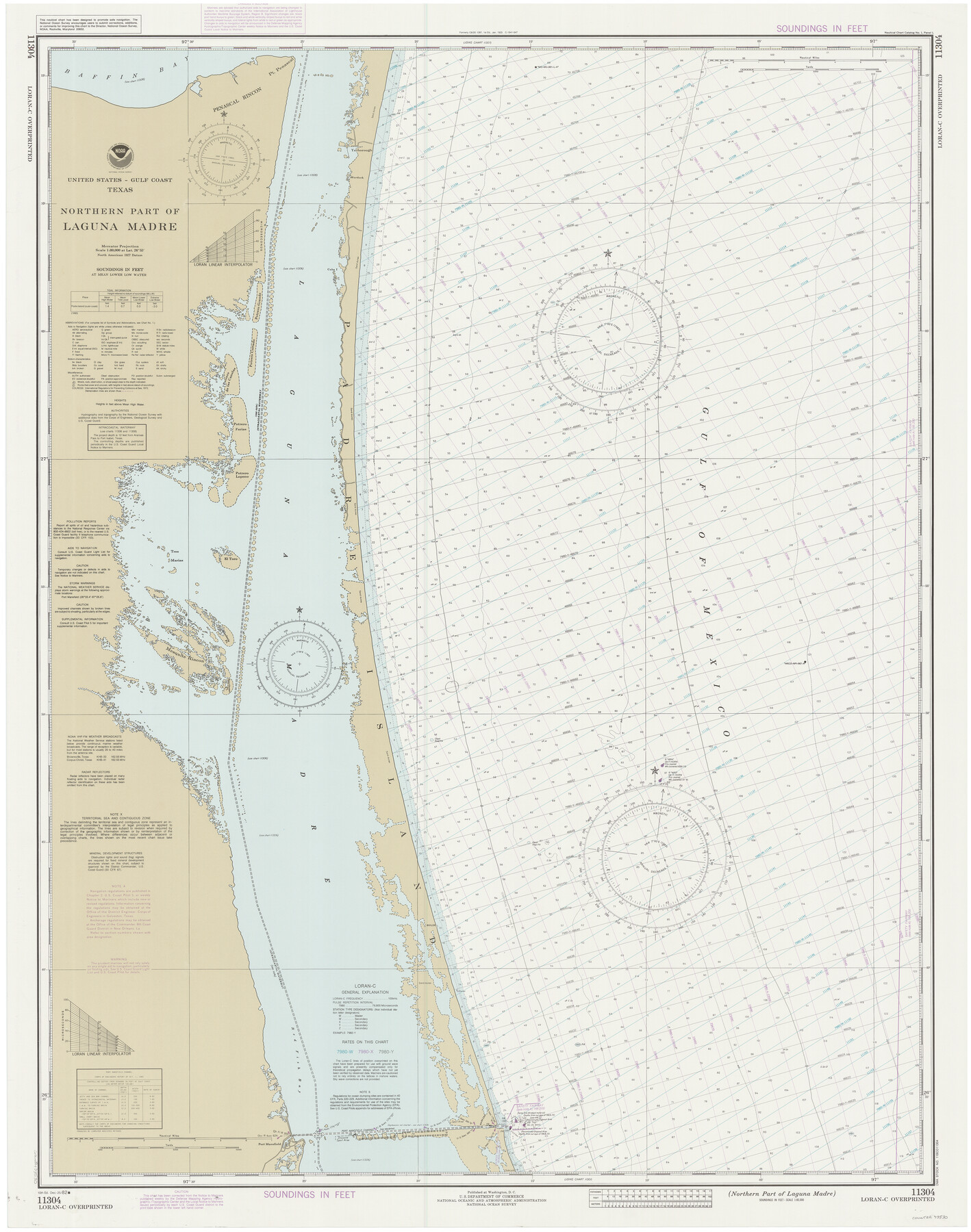
Northern Part of Laguna Madre
K-6-1287a
-
Map/Doc
73530
-
Collection
General Map Collection
-
Object Dates
12/25/1982 (Creation Date)
-
Counties
Kenedy Willacy
-
Subjects
Nautical Charts
-
Height x Width
44.2 x 35.0 inches
112.3 x 88.9 cm
Part of: General Map Collection
Traced from Genl. Arista's map captured by the American Army under Genl. Taylor at Resaca de la Palma 9th May '46 and presented to James K. Polk, President U. States

Print $20.00
- Digital $50.00
Traced from Genl. Arista's map captured by the American Army under Genl. Taylor at Resaca de la Palma 9th May '46 and presented to James K. Polk, President U. States
1846
Size 18.2 x 27.3 inches
Map/Doc 73060
Trinity County

Print $20.00
- Digital $50.00
Trinity County
1946
Size 42.5 x 42.8 inches
Map/Doc 73306
Menard County Rolled Sketch 7

Print $20.00
- Digital $50.00
Menard County Rolled Sketch 7
Size 43.2 x 37.3 inches
Map/Doc 9509
Flight Mission No. DQO-14T, Frame 65, Galveston County

Print $20.00
- Digital $50.00
Flight Mission No. DQO-14T, Frame 65, Galveston County
1958
Size 17.6 x 17.4 inches
Map/Doc 85216
La Salle County Rolled Sketch 7

Print $40.00
- Digital $50.00
La Salle County Rolled Sketch 7
Size 38.7 x 48.0 inches
Map/Doc 10652
Andrews County

Print $40.00
- Digital $50.00
Andrews County
1951
Size 43.7 x 55.4 inches
Map/Doc 95416
Presidio County Rolled Sketch 2

Print $20.00
- Digital $50.00
Presidio County Rolled Sketch 2
Size 30.2 x 18.6 inches
Map/Doc 7326
Kleberg County Rolled Sketch 10-35

Print $20.00
- Digital $50.00
Kleberg County Rolled Sketch 10-35
1952
Size 38.2 x 35.4 inches
Map/Doc 9366
Cameron County Sketch File 4

Print $52.00
- Digital $50.00
Cameron County Sketch File 4
1968
Size 11.3 x 8.8 inches
Map/Doc 17024
Map of Caldwell County, Land District since August 1st. 1859; Originally the part north, east of the line designated Bastrop - the balance, Gonzales Land District

Print $20.00
- Digital $50.00
Map of Caldwell County, Land District since August 1st. 1859; Originally the part north, east of the line designated Bastrop - the balance, Gonzales Land District
1861
Size 19.9 x 23.0 inches
Map/Doc 3355
Hood County Sketch File 17

Print $4.00
- Digital $50.00
Hood County Sketch File 17
1860
Size 8.2 x 9.4 inches
Map/Doc 26599
Lavaca County Working Sketch 24

Print $20.00
- Digital $50.00
Lavaca County Working Sketch 24
1985
Size 29.5 x 35.7 inches
Map/Doc 70377
You may also like
San Jacinto County Rolled Sketch 14

Print $20.00
- Digital $50.00
San Jacinto County Rolled Sketch 14
1998
Size 28.0 x 40.0 inches
Map/Doc 7565
Real County Working Sketch 29

Print $40.00
- Digital $50.00
Real County Working Sketch 29
1947
Size 58.2 x 40.5 inches
Map/Doc 71921
Slaton-Tex Water System

Print $20.00
- Digital $50.00
Slaton-Tex Water System
1922
Size 47.7 x 37.6 inches
Map/Doc 92818
Refugio County Rolled Sketch 6

Print $20.00
- Digital $50.00
Refugio County Rolled Sketch 6
1892
Size 28.7 x 29.2 inches
Map/Doc 7507
Famous Heights Addition to Amarillo, Potter Co. Texas

Print $20.00
- Digital $50.00
Famous Heights Addition to Amarillo, Potter Co. Texas
Size 18.6 x 10.0 inches
Map/Doc 91744
[T. & P. Block U and H. & T. C. Block 1]
![91871, [T. & P. Block U and H. & T. C. Block 1], Twichell Survey Records](https://historictexasmaps.com/wmedia_w700/maps/91871-1.tif.jpg)
Print $20.00
- Digital $50.00
[T. & P. Block U and H. & T. C. Block 1]
Size 20.5 x 16.7 inches
Map/Doc 91871
Angelina County Working Sketch 28

Print $20.00
- Digital $50.00
Angelina County Working Sketch 28
1954
Size 28.9 x 26.0 inches
Map/Doc 67110
Texas & Pacific R. R. through Pecos-Presidio Counties

Print $40.00
- Digital $50.00
Texas & Pacific R. R. through Pecos-Presidio Counties
Size 20.3 x 70.7 inches
Map/Doc 64282
Dawson County Sketch File 10

Print $4.00
- Digital $50.00
Dawson County Sketch File 10
1927
Size 11.4 x 8.8 inches
Map/Doc 20544
Sketches of Surveys in Montgomery Co.

Print $2.00
- Digital $50.00
Sketches of Surveys in Montgomery Co.
1845
Size 10.2 x 8.0 inches
Map/Doc 69731
[Map of Line Dividing Fannin and Nacogdoches Districts]
![1707, [Map of Line Dividing Fannin and Nacogdoches Districts], General Map Collection](https://historictexasmaps.com/wmedia_w700/maps/1707-1.tif.jpg)
Print $20.00
- Digital $50.00
[Map of Line Dividing Fannin and Nacogdoches Districts]
1850
Size 34.2 x 39.0 inches
Map/Doc 1707
McMullen County Working Sketch 56

Print $20.00
- Digital $50.00
McMullen County Working Sketch 56
1983
Size 23.9 x 24.1 inches
Map/Doc 70757