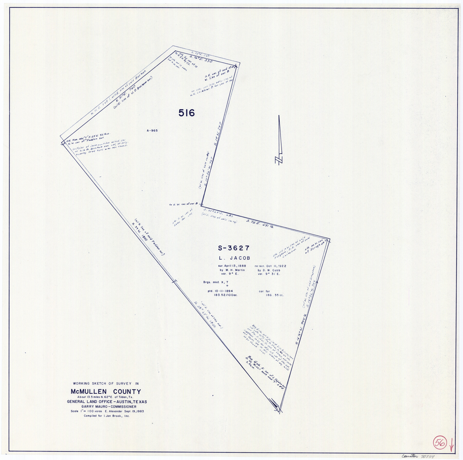
McMullen County Working Sketch 56
-
Map/Doc
70757
-
Collection
General Map Collection
-
Object Dates
9/19/1983 (Creation Date)
-
People and Organizations
Earl Alexander (Draftsman)
-
Counties
McMullen
-
Subjects
Surveying Working Sketch
-
Height x Width
23.9 x 24.1 inches
60.7 x 61.2 cm
-
Scale
1" = 100 varas
Part of: General Map Collection
Stonewall County

Print $20.00
- Digital $50.00
Stonewall County
1933
Size 47.6 x 39.5 inches
Map/Doc 73295
Colonists' and Emigrants' Route to Texas

Print $20.00
- Digital $50.00
Colonists' and Emigrants' Route to Texas
1878
Size 14.8 x 24.0 inches
Map/Doc 94033
La Salle County Working Sketch 14

Print $20.00
- Digital $50.00
La Salle County Working Sketch 14
1941
Size 37.8 x 36.7 inches
Map/Doc 70315
Spanish Dominions in North America, Northern Part

Print $20.00
- Digital $50.00
Spanish Dominions in North America, Northern Part
1811
Size 22.1 x 30.5 inches
Map/Doc 95133
Freestone County Working Sketch 5

Print $40.00
- Digital $50.00
Freestone County Working Sketch 5
Size 37.8 x 67.4 inches
Map/Doc 69247
Cottle County Sketch File 7

Print $20.00
- Digital $50.00
Cottle County Sketch File 7
1893
Size 22.1 x 20.7 inches
Map/Doc 11191
Lipscomb County Boundary File 15

Print $44.00
- Digital $50.00
Lipscomb County Boundary File 15
Size 11.3 x 8.7 inches
Map/Doc 56382
Houston County Sketch File 7

Print $6.00
- Digital $50.00
Houston County Sketch File 7
1861
Size 12.0 x 11.1 inches
Map/Doc 26764
Young County Sketch File 3

Print $4.00
- Digital $50.00
Young County Sketch File 3
1854
Size 12.3 x 8.2 inches
Map/Doc 40847
Reagan County Sketch File 20

Print $4.00
- Digital $50.00
Reagan County Sketch File 20
Size 14.5 x 9.0 inches
Map/Doc 35011
Palo Pinto County Working Sketch 18

Print $20.00
- Digital $50.00
Palo Pinto County Working Sketch 18
1974
Size 30.5 x 37.3 inches
Map/Doc 71401
Brazoria County Working Sketch 31

Print $20.00
- Digital $50.00
Brazoria County Working Sketch 31
1977
Size 26.3 x 31.7 inches
Map/Doc 67516
You may also like
Red River County Working Sketch 54

Print $20.00
- Digital $50.00
Red River County Working Sketch 54
1971
Size 19.3 x 31.1 inches
Map/Doc 72037
Grayson County Sketch File 3a

Print $20.00
- Digital $50.00
Grayson County Sketch File 3a
1855
Size 19.6 x 25.5 inches
Map/Doc 11580
Sutton County Rolled Sketch 51

Print $20.00
- Digital $50.00
Sutton County Rolled Sketch 51
1950
Size 29.6 x 16.4 inches
Map/Doc 7891
Denton County Sketch File 15

Print $8.00
- Digital $50.00
Denton County Sketch File 15
1857
Size 13.1 x 8.2 inches
Map/Doc 20724
Flight Mission No. CLL-1N, Frame 34, Willacy County

Print $20.00
- Digital $50.00
Flight Mission No. CLL-1N, Frame 34, Willacy County
1954
Size 18.4 x 22.2 inches
Map/Doc 87015
Jefferson County Rolled Sketch 48

Print $20.00
- Digital $50.00
Jefferson County Rolled Sketch 48
1963
Size 28.3 x 34.8 inches
Map/Doc 6403
Flight Mission No. DQN-3K, Frame 35, Calhoun County

Print $20.00
- Digital $50.00
Flight Mission No. DQN-3K, Frame 35, Calhoun County
1953
Size 16.4 x 16.2 inches
Map/Doc 84348
Map of Shackelford County, Texas

Print $20.00
- Digital $50.00
Map of Shackelford County, Texas
Size 47.3 x 42.8 inches
Map/Doc 78398
Plat of S. F. No. 12462, S. F. No. 12461, and Adjacent Sur.

Print $20.00
- Digital $50.00
Plat of S. F. No. 12462, S. F. No. 12461, and Adjacent Sur.
1922
Size 21.2 x 20.1 inches
Map/Doc 90172
Loving County Rolled Sketch 4

Print $40.00
- Digital $50.00
Loving County Rolled Sketch 4
1952
Size 82.2 x 19.5 inches
Map/Doc 9465
Map of Motley County

Print $20.00
- Digital $50.00
Map of Motley County
1902
Size 43.4 x 37.7 inches
Map/Doc 10799
Maverick County Working Sketch Graphic Index

Print $20.00
- Digital $50.00
Maverick County Working Sketch Graphic Index
1947
Size 46.4 x 30.3 inches
Map/Doc 76635