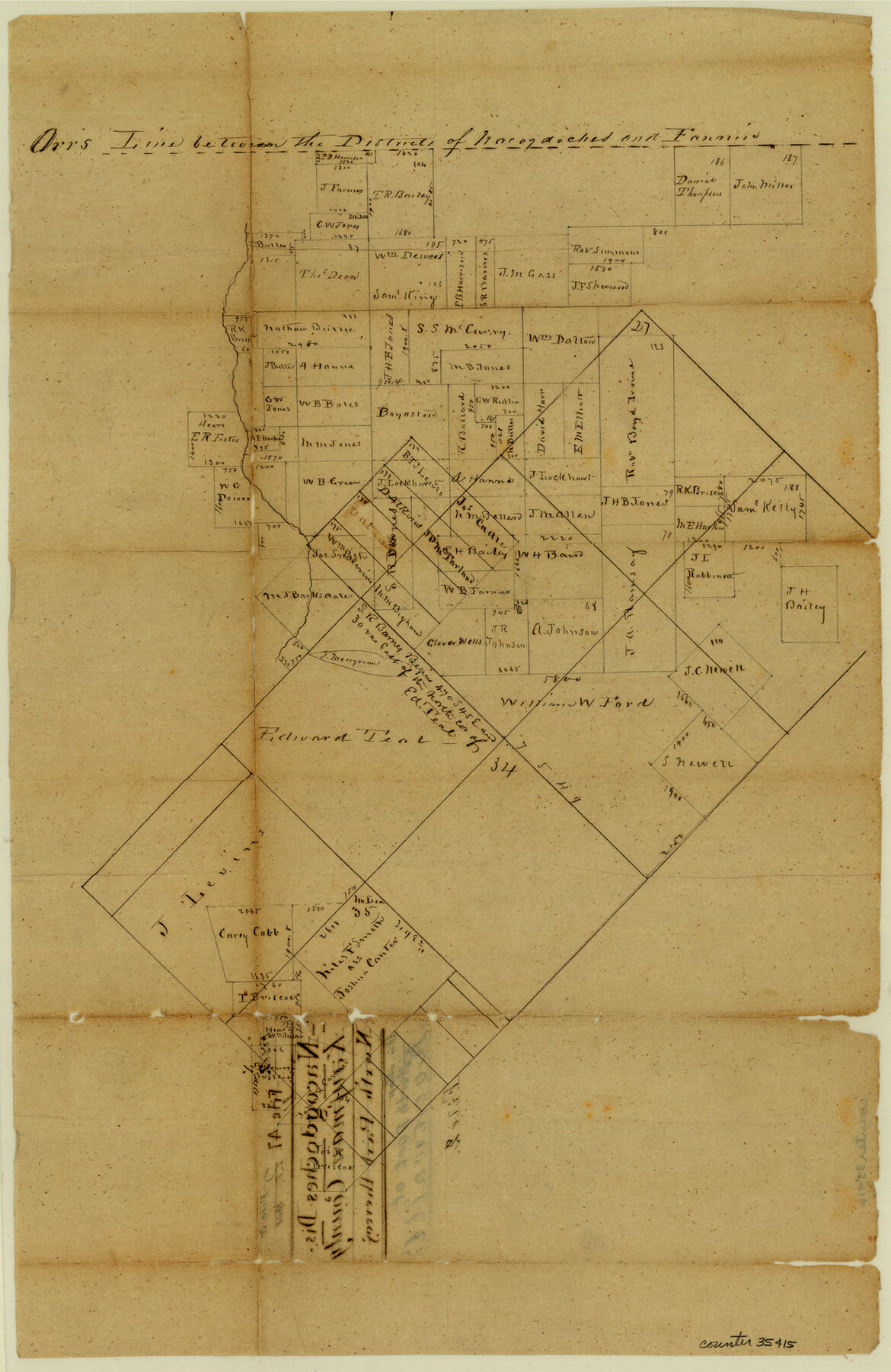
Rockwall County Sketch File 2
[Sketch of most of Rockwall County south of the line between the Districts of Nacogdoches and Fannin]
-
Map/Doc
35415
-
Collection
General Map Collection
-
Object Dates
1858 (File Date)
-
Counties
Rockwall
-
Subjects
Surveying Sketch File
-
Height x Width
17.3 x 11.2 inches
43.9 x 28.5 cm
-
Medium
paper, manuscript
Part of: General Map Collection
Shackelford County Boundary File 7b

Print $90.00
- Digital $50.00
Shackelford County Boundary File 7b
Size 7.9 x 10.4 inches
Map/Doc 58692
Motley County Sketch File C (N)

Print $48.00
- Digital $50.00
Motley County Sketch File C (N)
Size 7.7 x 18.4 inches
Map/Doc 31978
Moore County Rolled Sketch 14A

Print $20.00
- Digital $50.00
Moore County Rolled Sketch 14A
1981
Size 21.8 x 27.5 inches
Map/Doc 6831
Culberson County Rolled Sketch 52

Print $20.00
- Digital $50.00
Culberson County Rolled Sketch 52
Size 19.0 x 24.8 inches
Map/Doc 5673
Mason County Boundary File 63

Print $10.00
- Digital $50.00
Mason County Boundary File 63
Size 9.4 x 5.9 inches
Map/Doc 56879
Presidio County Working Sketch 128

Print $20.00
- Digital $50.00
Presidio County Working Sketch 128
1987
Size 37.3 x 29.0 inches
Map/Doc 71806
Leon County Sketch File 38

Print $10.00
- Digital $50.00
Leon County Sketch File 38
1999
Size 11.0 x 8.5 inches
Map/Doc 29878
Topographic Map, Reynard Sheet, Trinity River; Houston and Leon Counties

Print $20.00
- Digital $50.00
Topographic Map, Reynard Sheet, Trinity River; Houston and Leon Counties
1925
Size 45.6 x 41.4 inches
Map/Doc 2469
San Augustine County Working Sketch 28

Print $20.00
- Digital $50.00
San Augustine County Working Sketch 28
2011
Size 23.4 x 36.7 inches
Map/Doc 90091
Brewster County Sketch File 56

Print $14.00
- Digital $50.00
Brewster County Sketch File 56
2001
Size 11.0 x 8.5 inches
Map/Doc 16392
Pecos County Rolled Sketch 105

Print $20.00
- Digital $50.00
Pecos County Rolled Sketch 105
1940
Size 30.7 x 37.7 inches
Map/Doc 9717
United States - Gulf Coast - Galveston to Rio Grande

Print $20.00
- Digital $50.00
United States - Gulf Coast - Galveston to Rio Grande
1919
Size 27.0 x 18.2 inches
Map/Doc 72748
You may also like
Hidalgo County Working Sketch 1

Print $20.00
- Digital $50.00
Hidalgo County Working Sketch 1
1939
Size 24.8 x 21.4 inches
Map/Doc 66178
Map of Nacogdoches County

Print $20.00
- Digital $50.00
Map of Nacogdoches County
1857
Size 22.9 x 24.3 inches
Map/Doc 3907
Map of Part of the YL Ranch

Print $20.00
- Digital $50.00
Map of Part of the YL Ranch
1917
Size 29.1 x 27.3 inches
Map/Doc 4442
Montague County Working Sketch 26

Print $20.00
- Digital $50.00
Montague County Working Sketch 26
1956
Size 23.5 x 23.2 inches
Map/Doc 71092
Navarro County Working Sketch Graphic Index

Print $40.00
- Digital $50.00
Navarro County Working Sketch Graphic Index
1924
Size 42.7 x 48.7 inches
Map/Doc 76652
No. 1 - Survey for a road from the Brazo Santiago to the Rio Grande

Print $20.00
- Digital $50.00
No. 1 - Survey for a road from the Brazo Santiago to the Rio Grande
1847
Size 18.3 x 27.1 inches
Map/Doc 72877
Presidio County Rolled Sketch 68

Print $20.00
- Digital $50.00
Presidio County Rolled Sketch 68
1927
Size 11.8 x 24.4 inches
Map/Doc 7358
Jeff Davis County Working Sketch 26

Print $20.00
- Digital $50.00
Jeff Davis County Working Sketch 26
1960
Size 22.0 x 32.6 inches
Map/Doc 66521
South Sulphur River, Harpers Crossing Sheet

Print $20.00
- Digital $50.00
South Sulphur River, Harpers Crossing Sheet
1925
Size 42.2 x 29.2 inches
Map/Doc 65169
Matagorda County Texas

Print $20.00
- Digital $50.00
Matagorda County Texas
1896
Size 30.8 x 27.3 inches
Map/Doc 3845
![90573, [Block 3], Twichell Survey Records](https://historictexasmaps.com/wmedia_w700/maps/90573-1.tif.jpg)
Map from the Sabine River to the Rio Grande as subdivided for mineral development

Print $20.00
- Digital $50.00
Map from the Sabine River to the Rio Grande as subdivided for mineral development
Size 30.6 x 44.8 inches
Map/Doc 65801