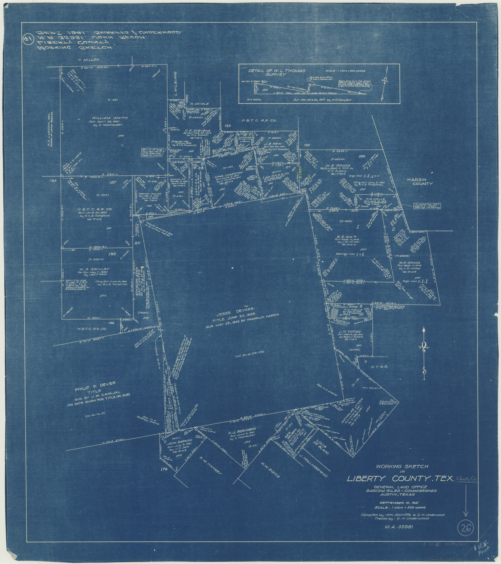
Liberty County Working Sketch 26
-
Map/Doc
70485
-
Collection
General Map Collection
-
Object Dates
9/15/1941 (Creation Date)
-
People and Organizations
William Shirriffs (Compiler)
D.H. Underwood (Draftsman)
-
Counties
Liberty
-
Subjects
Surveying Working Sketch
-
Height x Width
29.8 x 26.4 inches
75.7 x 67.1 cm
-
Scale
1" = 500 varas
Part of: General Map Collection
Tarrant County Working Sketch 24

Print $20.00
- Digital $50.00
Tarrant County Working Sketch 24
2003
Size 26.0 x 34.9 inches
Map/Doc 78642
Upton County Working Sketch 48

Print $20.00
- Digital $50.00
Upton County Working Sketch 48
1975
Size 29.3 x 24.3 inches
Map/Doc 69544
Travis County Rolled Sketch 4

Print $20.00
- Digital $50.00
Travis County Rolled Sketch 4
1915
Size 19.7 x 35.6 inches
Map/Doc 8010
Starr County Working Sketch 30

Print $20.00
- Digital $50.00
Starr County Working Sketch 30
2015
Size 24.6 x 36.6 inches
Map/Doc 93750
Lee County & Burleson County

Print $20.00
- Digital $50.00
Lee County & Burleson County
1867
Size 18.0 x 31.9 inches
Map/Doc 3346
Galveston County Sketch File 42

Print $20.00
- Digital $50.00
Galveston County Sketch File 42
1899
Size 23.9 x 23.7 inches
Map/Doc 11538
Flight Mission No. CRK-5P, Frame 158, Refugio County

Print $20.00
- Digital $50.00
Flight Mission No. CRK-5P, Frame 158, Refugio County
1956
Size 18.6 x 22.5 inches
Map/Doc 86939
Map of Jackson County

Print $20.00
- Digital $50.00
Map of Jackson County
1840
Size 34.9 x 25.3 inches
Map/Doc 3707
Flight Mission No. DCL-4C, Frame 69, Kenedy County

Print $20.00
- Digital $50.00
Flight Mission No. DCL-4C, Frame 69, Kenedy County
1943
Size 18.7 x 22.3 inches
Map/Doc 85814
Knox County Rolled Sketch 17

Print $20.00
- Digital $50.00
Knox County Rolled Sketch 17
1892
Size 31.0 x 39.2 inches
Map/Doc 10670

Presidio County Working Sketch 67

Print $20.00
- Digital $50.00
Presidio County Working Sketch 67
1960
Size 36.2 x 36.5 inches
Map/Doc 71744
You may also like
Map of Runnels County

Print $20.00
- Digital $50.00
Map of Runnels County
1898
Size 44.7 x 39.5 inches
Map/Doc 63008
Sketch of a reconnaissance of Aransas and Corpus Christi Bays

Print $20.00
- Digital $50.00
Sketch of a reconnaissance of Aransas and Corpus Christi Bays
1855
Size 25.7 x 18.3 inches
Map/Doc 72969
Hartley County Boundary File 5

Print $6.00
- Digital $50.00
Hartley County Boundary File 5
Size 12.7 x 8.2 inches
Map/Doc 54515
Atascosa County Rolled Sketch 24

Print $20.00
- Digital $50.00
Atascosa County Rolled Sketch 24
Size 38.3 x 45.2 inches
Map/Doc 5101
Sabine Bank to East Bay including Heald Bank

Print $20.00
- Digital $50.00
Sabine Bank to East Bay including Heald Bank
1946
Size 44.8 x 33.9 inches
Map/Doc 69845
Williamson County Working Sketch 6

Print $20.00
- Digital $50.00
Williamson County Working Sketch 6
1938
Size 11.2 x 18.6 inches
Map/Doc 72566
San Saba County Working Sketch 3

Print $20.00
- Digital $50.00
San Saba County Working Sketch 3
1941
Size 27.3 x 20.7 inches
Map/Doc 63791
Pecos County Working Sketch 105

Print $40.00
- Digital $50.00
Pecos County Working Sketch 105
1971
Size 49.3 x 43.5 inches
Map/Doc 71578
Map of the State of Texas

Print $40.00
- Digital $50.00
Map of the State of Texas
1879
Size 102.7 x 56.3 inches
Map/Doc 93382
Leon County Working Sketch 13

Print $20.00
- Digital $50.00
Leon County Working Sketch 13
1956
Size 23.0 x 22.7 inches
Map/Doc 70412
Map of the Recognised Line M. El. P. & P. R.R. from Texas & Arkansas State Line to Milam & Bexar Land District Line

Print $40.00
- Digital $50.00
Map of the Recognised Line M. El. P. & P. R.R. from Texas & Arkansas State Line to Milam & Bexar Land District Line
1856
Size 14.3 x 89.8 inches
Map/Doc 64053
Jeff Davis County Working Sketch 23

Print $20.00
- Digital $50.00
Jeff Davis County Working Sketch 23
1958
Size 41.5 x 30.7 inches
Map/Doc 66518