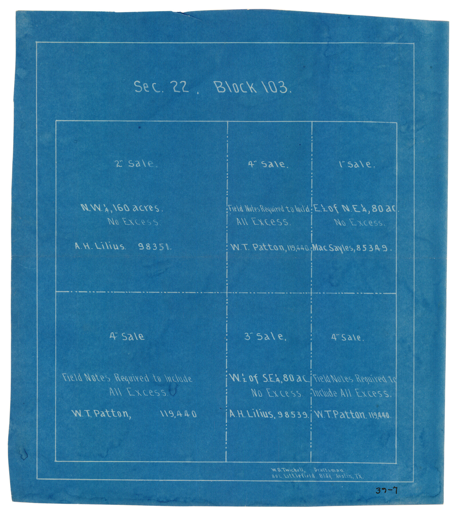
Sec. 22, Block 103
39-7
-
Map/Doc
90431
-
Collection
Twichell Survey Records
-
People and Organizations
W.D. Twichell (Draftsman)
-
Counties
Clay
-
Height x Width
8.4 x 9.5 inches
21.3 x 24.1 cm
Part of: Twichell Survey Records
[E. L. & R. R. RR. Blk. 32 and Blk.10 in Northwest corner of County]
![90124, [E. L. & R. R. RR. Blk. 32 and Blk.10 in Northwest corner of County], Twichell Survey Records](https://historictexasmaps.com/wmedia_w700/maps/90124-1.tif.jpg)
Print $2.00
- Digital $50.00
[E. L. & R. R. RR. Blk. 32 and Blk.10 in Northwest corner of County]
Size 14.2 x 8.7 inches
Map/Doc 90124
[Sutton, Hale & Ector Co. School Land]
![90103, [Sutton, Hale & Ector Co. School Land], Twichell Survey Records](https://historictexasmaps.com/wmedia_w700/maps/90103-1.tif.jpg)
Print $3.00
- Digital $50.00
[Sutton, Hale & Ector Co. School Land]
Size 9.8 x 16.7 inches
Map/Doc 90103

Sylvan Sanders Survey Section 20, Block A

Print $20.00
- Digital $50.00
Sylvan Sanders Survey Section 20, Block A
1952
Size 37.0 x 25.1 inches
Map/Doc 92722
Plat Proposed Location of Highway From Plains to Intersect Lovington Highway on New Mexico State Line

Print $20.00
- Digital $50.00
Plat Proposed Location of Highway From Plains to Intersect Lovington Highway on New Mexico State Line
Size 44.2 x 17.3 inches
Map/Doc 92856
Tech Memorial Park Street Grading Plan

Print $20.00
- Digital $50.00
Tech Memorial Park Street Grading Plan
1948
Size 17.8 x 15.7 inches
Map/Doc 92272
Plains Addition to Seagraves, Gaines County, Texas

Print $20.00
- Digital $50.00
Plains Addition to Seagraves, Gaines County, Texas
1948
Size 30.0 x 33.0 inches
Map/Doc 92691
Robertson V Ranch

Print $20.00
- Digital $50.00
Robertson V Ranch
Size 41.7 x 46.0 inches
Map/Doc 89756
Revised Plat of Tahoka Heights Addition Located on the SE 1/4 of Section 568

Print $20.00
- Digital $50.00
Revised Plat of Tahoka Heights Addition Located on the SE 1/4 of Section 568
Size 17.5 x 21.9 inches
Map/Doc 92942
[Blocks W, A4, A2, T, D10, B, JD, O, JK4]
![92251, [Blocks W, A4, A2, T, D10, B, JD, O, JK4], Twichell Survey Records](https://historictexasmaps.com/wmedia_w700/maps/92251-1.tif.jpg)
Print $20.00
- Digital $50.00
[Blocks W, A4, A2, T, D10, B, JD, O, JK4]
Size 36.9 x 30.1 inches
Map/Doc 92251
Plat Showing Part of Block Y, W. D. and F. W. Johnson Subdivision Number 2; and Part of Block W, Edward K. Warren Subdivision Number 1

Print $20.00
- Digital $50.00
Plat Showing Part of Block Y, W. D. and F. W. Johnson Subdivision Number 2; and Part of Block W, Edward K. Warren Subdivision Number 1
1954
Size 23.3 x 17.4 inches
Map/Doc 92502
[Sketch of area in dispute between Archibald Smith and Cyrena McReara Surveys]
![91923, [Sketch of area in dispute between Archibald Smith and Cyrena McReara Surveys], Twichell Survey Records](https://historictexasmaps.com/wmedia_w700/maps/91923-1.tif.jpg)
Print $20.00
- Digital $50.00
[Sketch of area in dispute between Archibald Smith and Cyrena McReara Surveys]
Size 27.8 x 31.9 inches
Map/Doc 91923
You may also like
[Township 3 North, Blocks 33 and 34, T. & P. RR. Company; Township 4 North, Block 33, T. & P. RR. Company]
![92564, [Township 3 North, Blocks 33 and 34, T. & P. RR. Company; Township 4 North, Block 33, T. & P. RR. Company], Twichell Survey Records](https://historictexasmaps.com/wmedia_w700/maps/92564-1.tif.jpg)
Print $20.00
- Digital $50.00
[Township 3 North, Blocks 33 and 34, T. & P. RR. Company; Township 4 North, Block 33, T. & P. RR. Company]
1911
Size 18.6 x 24.8 inches
Map/Doc 92564
Liberty County Working Sketch 21

Print $20.00
- Digital $50.00
Liberty County Working Sketch 21
1940
Size 20.1 x 15.0 inches
Map/Doc 70480
Hansford County Working Sketch 4

Print $20.00
- Digital $50.00
Hansford County Working Sketch 4
1940
Size 27.6 x 25.4 inches
Map/Doc 63376
Houston Ship Channel, Atkinson Island to Alexander Island

Print $20.00
- Digital $50.00
Houston Ship Channel, Atkinson Island to Alexander Island
1960
Size 33.2 x 44.0 inches
Map/Doc 69900
General Highway Map, Henderson County, Texas

Print $20.00
General Highway Map, Henderson County, Texas
1961
Size 24.8 x 18.2 inches
Map/Doc 79516
Texas and part of Mexico & the United States, showing the route of the first Santa Fe Expedition

Print $20.00
- Digital $50.00
Texas and part of Mexico & the United States, showing the route of the first Santa Fe Expedition
1844
Size 18.1 x 13.2 inches
Map/Doc 94035
Brown County Working Sketch 4

Print $20.00
- Digital $50.00
Brown County Working Sketch 4
1926
Size 23.4 x 22.4 inches
Map/Doc 67769
Grayson County Sketch File 28

Print $4.00
- Digital $50.00
Grayson County Sketch File 28
1990
Size 14.3 x 8.8 inches
Map/Doc 24517
Blanco County Boundary File 4

Print $24.00
- Digital $50.00
Blanco County Boundary File 4
Size 8.9 x 8.3 inches
Map/Doc 50543
Dickens County Rolled Sketch 5

Print $40.00
- Digital $50.00
Dickens County Rolled Sketch 5
1947
Size 60.2 x 40.3 inches
Map/Doc 8787
Lamar County Sketch File 10

Print $4.00
- Digital $50.00
Lamar County Sketch File 10
1872
Size 8.1 x 9.9 inches
Map/Doc 29293
