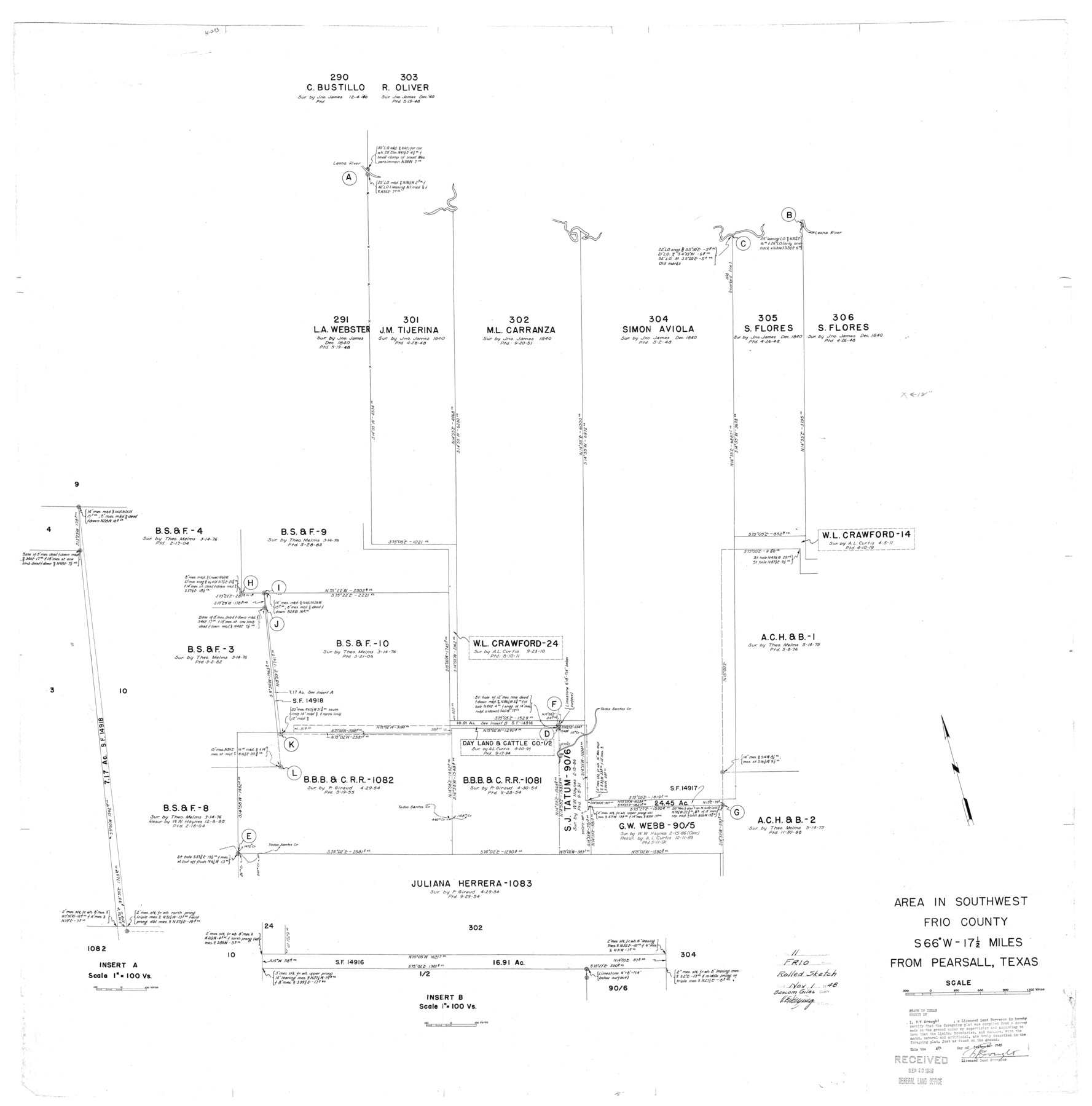
Frio County Rolled Sketch 11
Area in southwest Frio County
-
Map/Doc
8903
-
Collection
General Map Collection
-
Object Dates
1948/9/4 (Creation Date)
1948/11/1 (File Date)
-
People and Organizations
F.T. Drought (Surveyor/Engineer)
-
Counties
Frio
-
Subjects
Surveying Rolled Sketch
-
Height x Width
44.4 x 43.8 inches
112.8 x 111.3 cm
Part of: General Map Collection
Edwards County Working Sketch 71

Print $20.00
- Digital $50.00
Edwards County Working Sketch 71
1957
Size 17.4 x 23.8 inches
Map/Doc 68947
Tarrant County Working Sketch 1

Print $20.00
- Digital $50.00
Tarrant County Working Sketch 1
1939
Size 12.2 x 18.9 inches
Map/Doc 62418
Fannin County Sketch File 9a

Print $4.00
- Digital $50.00
Fannin County Sketch File 9a
Size 8.2 x 6.4 inches
Map/Doc 22455
[The S.K. Ry. of Texas, State Line to Pecos, Reeves Co., Texas]
![64163, [The S.K. Ry. of Texas, State Line to Pecos, Reeves Co., Texas], General Map Collection](https://historictexasmaps.com/wmedia_w700/maps/64163.tif.jpg)
Print $40.00
- Digital $50.00
[The S.K. Ry. of Texas, State Line to Pecos, Reeves Co., Texas]
1910
Size 19.3 x 120.2 inches
Map/Doc 64163
Freestone County Working Sketch 27

Print $20.00
- Digital $50.00
Freestone County Working Sketch 27
1986
Size 28.0 x 30.9 inches
Map/Doc 69269
Hardin County Sketch File A

Print $20.00
- Digital $50.00
Hardin County Sketch File A
Size 19.3 x 33.4 inches
Map/Doc 11644
Current Miscellaneous File 35

Print $10.00
- Digital $50.00
Current Miscellaneous File 35
Size 14.2 x 8.7 inches
Map/Doc 73947
Amistad International Reservoir on Rio Grande 95

Print $20.00
- Digital $50.00
Amistad International Reservoir on Rio Grande 95
1950
Size 28.5 x 40.1 inches
Map/Doc 75525
Map of Young County East of the Main Brazos River formerly Fannin and West of it Milam Land District

Print $20.00
- Digital $50.00
Map of Young County East of the Main Brazos River formerly Fannin and West of it Milam Land District
1859
Size 23.3 x 20.2 inches
Map/Doc 4173
Dawson County Sketch File 8

Print $12.00
- Digital $50.00
Dawson County Sketch File 8
1924
Size 11.3 x 9.0 inches
Map/Doc 20536
Bell County Sketch File 23a

Print $6.00
- Digital $50.00
Bell County Sketch File 23a
1873
Size 10.0 x 15.7 inches
Map/Doc 14416
[Galveston, Harrisburg & San Antonio from El Paso-Presidio county boundary to Presidio-Pecos county boundary]
![64718, [Galveston, Harrisburg & San Antonio from El Paso-Presidio county boundary to Presidio-Pecos county boundary], General Map Collection](https://historictexasmaps.com/wmedia_w700/maps/64718.tif.jpg)
Print $40.00
- Digital $50.00
[Galveston, Harrisburg & San Antonio from El Paso-Presidio county boundary to Presidio-Pecos county boundary]
Size 106.1 x 44.3 inches
Map/Doc 64718
You may also like
Dallas County Boundary File 4a

Print $60.00
- Digital $50.00
Dallas County Boundary File 4a
Size 14.0 x 8.4 inches
Map/Doc 52142
Harrison County Sketch File 15

Print $20.00
- Digital $50.00
Harrison County Sketch File 15
Size 23.2 x 23.0 inches
Map/Doc 11690
[Galveston, Harrisburg & San Antonio Railroad from Cuero to Stockdale]
![64192, [Galveston, Harrisburg & San Antonio Railroad from Cuero to Stockdale], General Map Collection](https://historictexasmaps.com/wmedia_w700/maps/64192.tif.jpg)
Print $20.00
- Digital $50.00
[Galveston, Harrisburg & San Antonio Railroad from Cuero to Stockdale]
1907
Size 14.1 x 34.1 inches
Map/Doc 64192
Donley County Sketch File B3

Print $20.00
- Digital $50.00
Donley County Sketch File B3
1918
Size 22.0 x 15.0 inches
Map/Doc 11373
Hudspeth County Rolled Sketch 66

Print $20.00
- Digital $50.00
Hudspeth County Rolled Sketch 66
1973
Size 11.7 x 18.2 inches
Map/Doc 6263
[Surveys in Austin's Colony at Carancahua Bay]
![172, [Surveys in Austin's Colony at Carancahua Bay], General Map Collection](https://historictexasmaps.com/wmedia_w700/maps/172.tif.jpg)
Print $20.00
- Digital $50.00
[Surveys in Austin's Colony at Carancahua Bay]
Size 22.5 x 17.4 inches
Map/Doc 172
Uvalde County Sketch File 31

Print $4.00
- Digital $50.00
Uvalde County Sketch File 31
Size 11.2 x 8.8 inches
Map/Doc 81529
Erath County Working Sketch 3

Print $20.00
- Digital $50.00
Erath County Working Sketch 3
1919
Size 17.6 x 17.6 inches
Map/Doc 69084
Sabine River, Watershed of the Sabine and Neches Rivers

Print $20.00
- Digital $50.00
Sabine River, Watershed of the Sabine and Neches Rivers
Size 39.5 x 36.0 inches
Map/Doc 65132
Winkler County Sketch File 15

Print $10.00
- Digital $50.00
Winkler County Sketch File 15
1944
Size 14.3 x 8.6 inches
Map/Doc 40488
Roberts County Working Sketch 43

Print $20.00
- Digital $50.00
Roberts County Working Sketch 43
1990
Size 19.3 x 37.6 inches
Map/Doc 63569
Flight Mission No. DAG-14K, Frame 142, Matagorda County

Print $20.00
- Digital $50.00
Flight Mission No. DAG-14K, Frame 142, Matagorda County
1952
Size 16.5 x 16.4 inches
Map/Doc 86309