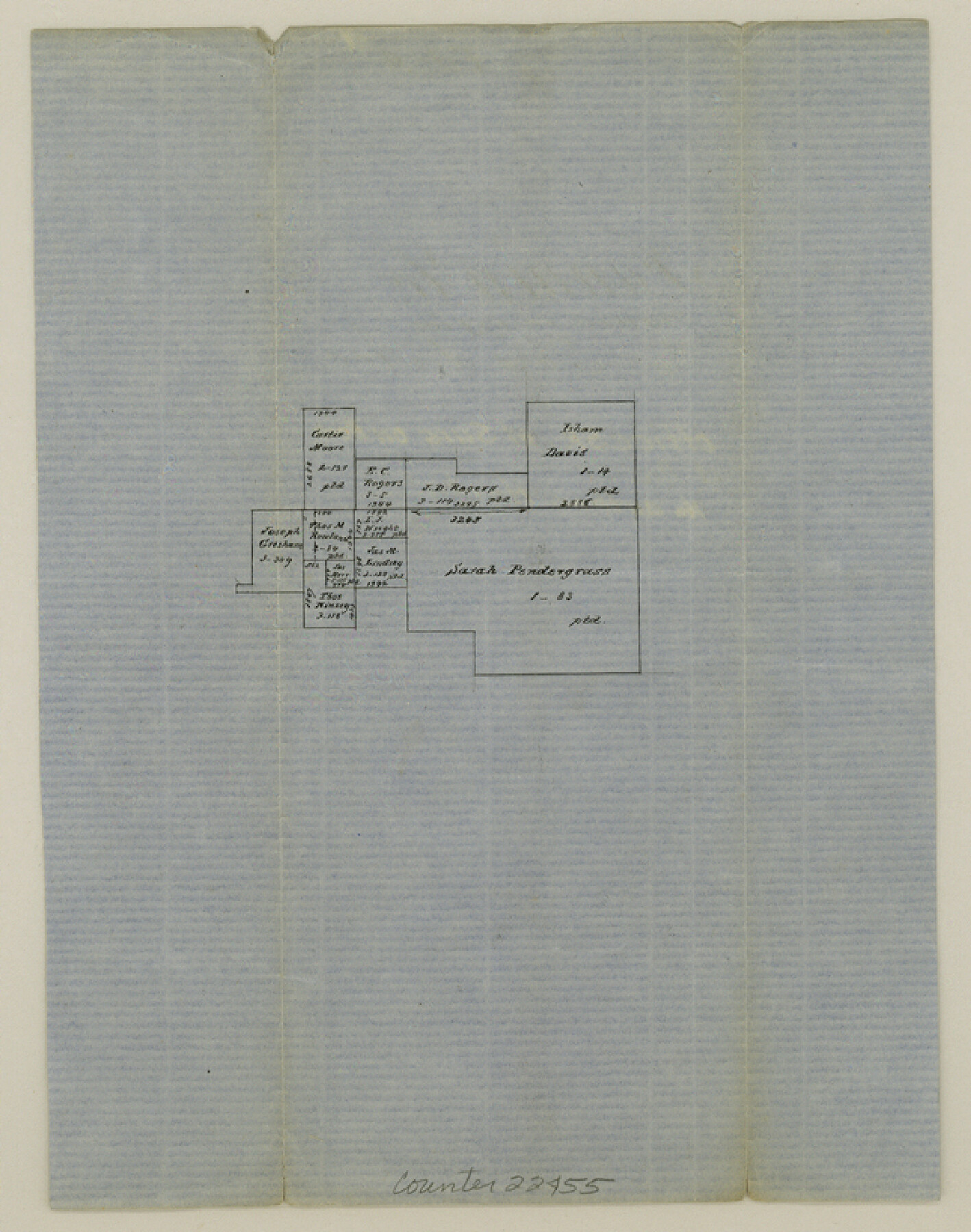
Fannin County Sketch File 9a
[Office sketch of surveys on Bois d'Arc Creek]
-
Map/Doc
22455
-
Collection
General Map Collection
-
Counties
Fannin
-
Subjects
Surveying Sketch File
-
Height x Width
8.2 x 6.4 inches
20.8 x 16.3 cm
-
Medium
paper, manuscript
-
Features
[Bois d'Arc Creek]
Part of: General Map Collection
Crockett County Rolled Sketch 77

Print $20.00
- Digital $50.00
Crockett County Rolled Sketch 77
1952
Size 26.9 x 28.6 inches
Map/Doc 5618
Harris County NRC Article 33.136 Location Key Sheet

Print $20.00
- Digital $50.00
Harris County NRC Article 33.136 Location Key Sheet
1995
Size 27.0 x 21.8 inches
Map/Doc 82992
Flight Mission No. BQR-4K, Frame 64, Brazoria County

Print $20.00
- Digital $50.00
Flight Mission No. BQR-4K, Frame 64, Brazoria County
1952
Size 18.7 x 22.4 inches
Map/Doc 83997
Foard County Sketch File 4

Print $5.00
- Digital $50.00
Foard County Sketch File 4
Size 12.4 x 9.5 inches
Map/Doc 22806
Midland County Rolled Sketch 4B

Print $40.00
- Digital $50.00
Midland County Rolled Sketch 4B
1951
Size 77.5 x 25.1 inches
Map/Doc 10725
Flight Mission No. CRC-3R, Frame 20, Chambers County

Print $20.00
- Digital $50.00
Flight Mission No. CRC-3R, Frame 20, Chambers County
1956
Size 18.6 x 22.2 inches
Map/Doc 84794
Visitor's Guide to Mexico City, D.F. [and Index to Cities and Villages and Route Summaries]
![96822, Visitor's Guide to Mexico City, D.F. [and Index to Cities and Villages and Route Summaries], General Map Collection](https://historictexasmaps.com/wmedia_w700/maps/96822.tif.jpg)
Visitor's Guide to Mexico City, D.F. [and Index to Cities and Villages and Route Summaries]
1999
Size 33.7 x 25.1 inches
Map/Doc 96822
Aransas County NRC Article 33.136 Sketch 5

Print $20.00
- Digital $50.00
Aransas County NRC Article 33.136 Sketch 5
2005
Size 18.5 x 24.7 inches
Map/Doc 83521
Hill County Sketch File 21

Print $4.00
- Digital $50.00
Hill County Sketch File 21
1856
Size 11.1 x 8.8 inches
Map/Doc 26501
Flight Mission No. DAH-9M, Frame 164, Orange County

Print $20.00
- Digital $50.00
Flight Mission No. DAH-9M, Frame 164, Orange County
1953
Size 18.6 x 22.3 inches
Map/Doc 86863
Map of Kaufman County showing location of the Texas and Pacific Railway

Print $20.00
- Digital $50.00
Map of Kaufman County showing location of the Texas and Pacific Railway
1872
Size 24.2 x 17.8 inches
Map/Doc 64138
La Salle County Working Sketch 5

Print $20.00
- Digital $50.00
La Salle County Working Sketch 5
1915
Size 17.2 x 13.4 inches
Map/Doc 70306
You may also like
Travis County Sketch File 8

Print $4.00
- Digital $50.00
Travis County Sketch File 8
Size 10.2 x 8.1 inches
Map/Doc 38288
Duval County Sketch File 45b

Print $40.00
- Digital $50.00
Duval County Sketch File 45b
1936
Size 26.0 x 18.1 inches
Map/Doc 11399
Right of Way Map, Belton Branch of the M.K.&T. RR.

Print $20.00
- Digital $50.00
Right of Way Map, Belton Branch of the M.K.&T. RR.
1896
Size 14.5 x 42.1 inches
Map/Doc 64219
[North half Dawson County, southwest quarter Lynn County, south half of Terry County, southeast quarter Yoakum County, north half Gaines County]
![93133, [North half Dawson County, southwest quarter Lynn County, south half of Terry County, southeast quarter Yoakum County, north half Gaines County], Twichell Survey Records](https://historictexasmaps.com/wmedia_w700/maps/93133-1.tif.jpg)
Print $40.00
- Digital $50.00
[North half Dawson County, southwest quarter Lynn County, south half of Terry County, southeast quarter Yoakum County, north half Gaines County]
Size 79.8 x 45.3 inches
Map/Doc 93133
Franklin County Sketch File 1c

Print $4.00
- Digital $50.00
Franklin County Sketch File 1c
1853
Size 10.3 x 8.1 inches
Map/Doc 23010
Right of Way and Track Map of The Missouri, Kansas & Texas Railway of Texas

Print $40.00
- Digital $50.00
Right of Way and Track Map of The Missouri, Kansas & Texas Railway of Texas
1918
Size 24.9 x 51.6 inches
Map/Doc 64535
[Blocks W and Z with tie lines]
![90451, [Blocks W and Z with tie lines], Twichell Survey Records](https://historictexasmaps.com/wmedia_w700/maps/90451-1.tif.jpg)
Print $20.00
- Digital $50.00
[Blocks W and Z with tie lines]
1949
Size 14.4 x 14.2 inches
Map/Doc 90451
Tarrant County Boundary File 5

Print $104.00
- Digital $50.00
Tarrant County Boundary File 5
Size 11.4 x 8.8 inches
Map/Doc 59161
Township 4 South Ranges 12 and 13 West, South Western District, Louisiana

Print $20.00
- Digital $50.00
Township 4 South Ranges 12 and 13 West, South Western District, Louisiana
1857
Size 18.6 x 24.2 inches
Map/Doc 65891
Blanco County Sketch File 47

Print $46.00
- Digital $50.00
Blanco County Sketch File 47
Size 14.4 x 8.7 inches
Map/Doc 14675
Pecos County Rolled Sketch 186

Print $20.00
- Digital $50.00
Pecos County Rolled Sketch 186
1985
Size 39.3 x 27.5 inches
Map/Doc 7305
Dickens County Sketch File F1

Print $28.00
- Digital $50.00
Dickens County Sketch File F1
Size 11.4 x 8.7 inches
Map/Doc 20849