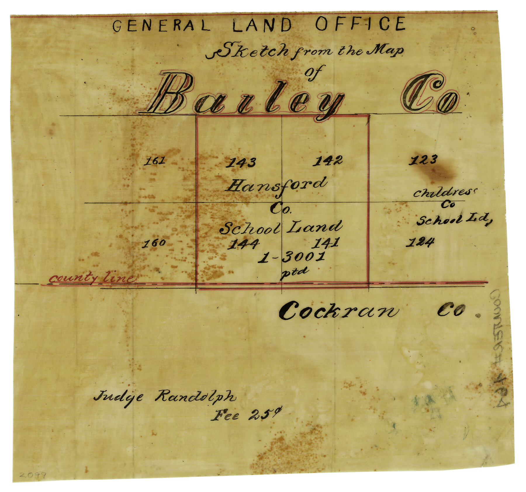
Sketch from the map of Bailey Co.
-
Map/Doc
464
-
Collection
Maddox Collection
-
People and Organizations
General Land Office (Publisher)
-
Counties
Bailey Cochran
-
Height x Width
8.4 x 7.6 inches
21.3 x 19.3 cm
-
Medium
linen, manuscript
Part of: Maddox Collection
[Sketch of a portion of Hutchinson County, Texas]
![413, [Sketch of a portion of Hutchinson County, Texas], Maddox Collection](https://historictexasmaps.com/wmedia_w700/maps/0413.tif.jpg)
Print $20.00
- Digital $50.00
[Sketch of a portion of Hutchinson County, Texas]
1889
Size 14.9 x 17.3 inches
Map/Doc 413
[Sketch of 'San Salvador del Tule', Juan Jose Balli Grant, Hidalgo County, Texas]
![10756, [Sketch of 'San Salvador del Tule', Juan Jose Balli Grant, Hidalgo County, Texas], Maddox Collection](https://historictexasmaps.com/wmedia_w700/maps/10756.tif.jpg)
Print $20.00
- Digital $50.00
[Sketch of 'San Salvador del Tule', Juan Jose Balli Grant, Hidalgo County, Texas]
Size 22.0 x 17.5 inches
Map/Doc 10756
[Wm. B. Jaques assee. of José Pineda, Kimble County, Texas]
![540, [Wm. B. Jaques assee. of José Pineda, Kimble County, Texas], Maddox Collection](https://historictexasmaps.com/wmedia_w700/maps/0540.tif.jpg)
Print $3.00
- Digital $50.00
[Wm. B. Jaques assee. of José Pineda, Kimble County, Texas]
Size 16.1 x 11.2 inches
Map/Doc 540
Survey in South Austin for Mr. R.N. Graham

Print $20.00
- Digital $50.00
Survey in South Austin for Mr. R.N. Graham
1915
Size 22.6 x 33.8 inches
Map/Doc 564
Hunt County, Texas

Print $20.00
- Digital $50.00
Hunt County, Texas
1871
Size 25.8 x 19.4 inches
Map/Doc 462
[Sketch of surveys in Knox County]
![555, [Sketch of surveys in Knox County], Maddox Collection](https://historictexasmaps.com/wmedia_w700/maps/555.tif.jpg)
Print $20.00
- Digital $50.00
[Sketch of surveys in Knox County]
Size 27.1 x 31.1 inches
Map/Doc 555
Martin County, Texas

Print $20.00
- Digital $50.00
Martin County, Texas
1870
Size 22.9 x 18.0 inches
Map/Doc 391

San Antonio del Encinal as Corrected

Print $20.00
- Digital $50.00
San Antonio del Encinal as Corrected
1916
Size 31.2 x 31.5 inches
Map/Doc 10757
Foard County, Texas

Print $20.00
- Digital $50.00
Foard County, Texas
1891
Size 19.5 x 20.7 inches
Map/Doc 727
Map of Surveys on Harbor Island

Print $40.00
- Digital $50.00
Map of Surveys on Harbor Island
1912
Size 57.3 x 42.2 inches
Map/Doc 594
[Robertson Co.]
![4488, [Robertson Co.], Maddox Collection](https://historictexasmaps.com/wmedia_w700/maps/4488.tif.jpg)
Print $20.00
- Digital $50.00
[Robertson Co.]
1880
Size 32.3 x 44.3 inches
Map/Doc 4488
You may also like
Van Zandt County Boundary File 2

Print $32.00
- Digital $50.00
Van Zandt County Boundary File 2
Size 13.0 x 8.1 inches
Map/Doc 59633
[Sketch showing Blocks A, S4, O6, JK, O5, O2, O, JK4, JD, A2, A1]
![89713, [Sketch showing Blocks A, S4, O6, JK, O5, O2, O, JK4, JD, A2, A1], Twichell Survey Records](https://historictexasmaps.com/wmedia_w700/maps/89713-1.tif.jpg)
Print $40.00
- Digital $50.00
[Sketch showing Blocks A, S4, O6, JK, O5, O2, O, JK4, JD, A2, A1]
Size 48.9 x 37.6 inches
Map/Doc 89713
Freestone County Sketch File 17

Print $4.00
- Digital $50.00
Freestone County Sketch File 17
1859
Size 6.3 x 8.1 inches
Map/Doc 23074
Angelina County Working Sketch 35

Print $20.00
- Digital $50.00
Angelina County Working Sketch 35
1957
Size 27.4 x 29.6 inches
Map/Doc 67118
La Salle County Working Sketch 25

Print $20.00
- Digital $50.00
La Salle County Working Sketch 25
1947
Size 32.8 x 41.0 inches
Map/Doc 70326
Flight Mission No. DQO-1K, Frame 40, Galveston County

Print $20.00
- Digital $50.00
Flight Mission No. DQO-1K, Frame 40, Galveston County
1952
Size 18.8 x 22.6 inches
Map/Doc 84983
Starr County Sketch File 34

Print $20.00
- Digital $50.00
Starr County Sketch File 34
1939
Size 15.8 x 17.6 inches
Map/Doc 12337
Ellwood Farms, Situated in Lamb County, Texas

Print $20.00
- Digital $50.00
Ellwood Farms, Situated in Lamb County, Texas
Size 12.5 x 22.8 inches
Map/Doc 90993

Runnels County Sketch File 16

Print $20.00
Runnels County Sketch File 16
1879
Size 17.0 x 9.1 inches
Map/Doc 35470
Brown County Working Sketch 15

Print $20.00
- Digital $50.00
Brown County Working Sketch 15
1989
Size 23.6 x 16.7 inches
Map/Doc 67780
Sutton County Working Sketch 39

Print $20.00
- Digital $50.00
Sutton County Working Sketch 39
1945
Size 29.6 x 25.8 inches
Map/Doc 62382