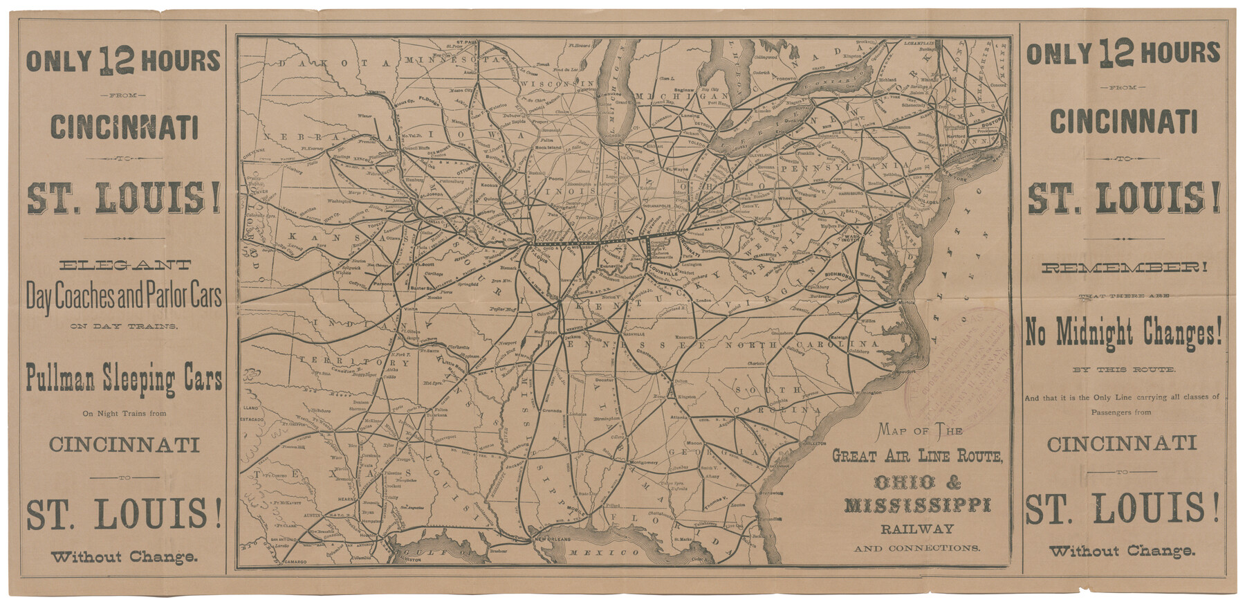
Map of the Great Air Line Route, Ohio & Mississippi Railway and connections
Great Reduction by the Ohio and Mississippi Railway and all points in Texas
-
Map/Doc
95820
-
Collection
Cobb Digital Map Collection
-
Object Dates
8/15/1878 (Creation Date)
-
Subjects
Railroads
-
Height x Width
12.8 x 26.4 inches
32.5 x 67.1 cm
-
Medium
digital image
-
Comments
Courtesy of John & Diana Cobb.
To view full booklet in which this map was contained, click "Download PDF" link above.
Part of: Cobb Digital Map Collection
Map Exhibiting the Leading Transportation Lines of the Pacific Coast, prepared for the report of the Chief of the Bureau of Statistics on the internal commerce of the United States

Print $20.00
- Digital $50.00
Map Exhibiting the Leading Transportation Lines of the Pacific Coast, prepared for the report of the Chief of the Bureau of Statistics on the internal commerce of the United States
1887
Size 22.2 x 24.5 inches
Map/Doc 95905
The Northern Pacific Railroad and Connections

Print $20.00
- Digital $50.00
The Northern Pacific Railroad and Connections
1892
Size 23.1 x 35.7 inches
Map/Doc 96583
A Geographically Correct County Map of States Traversed by the St. Louis, Iron Mountain & Southern Railway and its Connections

Print $20.00
- Digital $50.00
A Geographically Correct County Map of States Traversed by the St. Louis, Iron Mountain & Southern Railway and its Connections
1876
Size 18.6 x 15.9 inches
Map/Doc 95781
Timely Tips to Texas Truckers

Timely Tips to Texas Truckers
1906
Size 9.3 x 6.2 inches
Map/Doc 96609
Map of the St. Louis, Iron Mountain and Southern Railway, and connections

Print $20.00
- Digital $50.00
Map of the St. Louis, Iron Mountain and Southern Railway, and connections
1877
Size 13.0 x 18.9 inches
Map/Doc 95783
![[San Benito Promotional Booklet]](https://historictexasmaps.com/wmedia_w700/pdf_converted_jpg/qi_pdf_thumbnail_64211.jpg)
Map of the Iron Mountain Route - St. Louis, Iron Mountain and Southern Railway and connections, the great fast mail line to St. Louis, Arkansas and Texas

Print $20.00
- Digital $50.00
Map of the Iron Mountain Route - St. Louis, Iron Mountain and Southern Railway and connections, the great fast mail line to St. Louis, Arkansas and Texas
1882
Size 14.9 x 24.1 inches
Map/Doc 95787

The Principal Transportation Lines extending west from Boston, New York, Philadelphia, and Baltimore

Print $20.00
- Digital $50.00
The Principal Transportation Lines extending west from Boston, New York, Philadelphia, and Baltimore
1881
Size 17.1 x 24.4 inches
Map/Doc 95908
Rice Cook Book containing two hundred receipts for preparing rice

Rice Cook Book containing two hundred receipts for preparing rice
1901
Map/Doc 96721
Galveston The Year-'Round Resort

Galveston The Year-'Round Resort
1912
Size 7.8 x 10.2 inches
Map/Doc 97058

You may also like
General Highway Map, Brooks County, Texas

Print $20.00
General Highway Map, Brooks County, Texas
1961
Size 18.2 x 24.8 inches
Map/Doc 79388
Jules A. Appler's Map of San Antonio, Texas and Suburbs

Print $20.00
Jules A. Appler's Map of San Antonio, Texas and Suburbs
1900
Size 43.0 x 29.7 inches
Map/Doc 79303
Flight Mission No. 29300074, Harris County

Print $20.00
- Digital $50.00
Flight Mission No. 29300074, Harris County
1985
Size 10.4 x 10.4 inches
Map/Doc 85286
Blanco County Sketch File 16

Print $20.00
- Digital $50.00
Blanco County Sketch File 16
1861
Size 19.9 x 15.8 inches
Map/Doc 10929
Walker County Sketch File 8

Print $4.00
- Digital $50.00
Walker County Sketch File 8
1944
Size 9.7 x 6.8 inches
Map/Doc 39561
Flight Mission No. CUG-3P, Frame 14, Kleberg County

Print $20.00
- Digital $50.00
Flight Mission No. CUG-3P, Frame 14, Kleberg County
1956
Size 18.7 x 22.3 inches
Map/Doc 86224
Flight Mission No. DCL-4C, Frame 4, Kenedy County

Print $20.00
- Digital $50.00
Flight Mission No. DCL-4C, Frame 4, Kenedy County
1943
Size 18.7 x 22.3 inches
Map/Doc 85805
Culberson County Rolled Sketch 35

Print $20.00
- Digital $50.00
Culberson County Rolled Sketch 35
1934
Size 19.1 x 10.9 inches
Map/Doc 5659
Flight Mission No. DAG-21K, Frame 40, Matagorda County

Print $20.00
- Digital $50.00
Flight Mission No. DAG-21K, Frame 40, Matagorda County
1952
Size 18.6 x 19.3 inches
Map/Doc 86407
Padre Island Under Six Flags

Print $40.00
- Digital $50.00
Padre Island Under Six Flags
1962
Size 63.7 x 36.9 inches
Map/Doc 3126
[Location Survey of the Southern Kansas Railway, Kiowa Extension from a point in Drake's Location, in Indian Territory 100 miles from south line of Kansas, continuing up Wolf Creek and South Canadian River to Cottonwood Creek in Hutchinson County]
![88841, [Location Survey of the Southern Kansas Railway, Kiowa Extension from a point in Drake's Location, in Indian Territory 100 miles from south line of Kansas, continuing up Wolf Creek and South Canadian River to Cottonwood Creek in Hutchinson County], General Map Collection](https://historictexasmaps.com/wmedia_w700/maps/88841.tif.jpg)
Print $20.00
- Digital $50.00
[Location Survey of the Southern Kansas Railway, Kiowa Extension from a point in Drake's Location, in Indian Territory 100 miles from south line of Kansas, continuing up Wolf Creek and South Canadian River to Cottonwood Creek in Hutchinson County]
1886
Size 39.1 x 42.0 inches
Map/Doc 88841
Darrington Plantation of the Texas Prison System, Brazoria County

Print $20.00
- Digital $50.00
Darrington Plantation of the Texas Prison System, Brazoria County
Size 16.9 x 37.4 inches
Map/Doc 62986