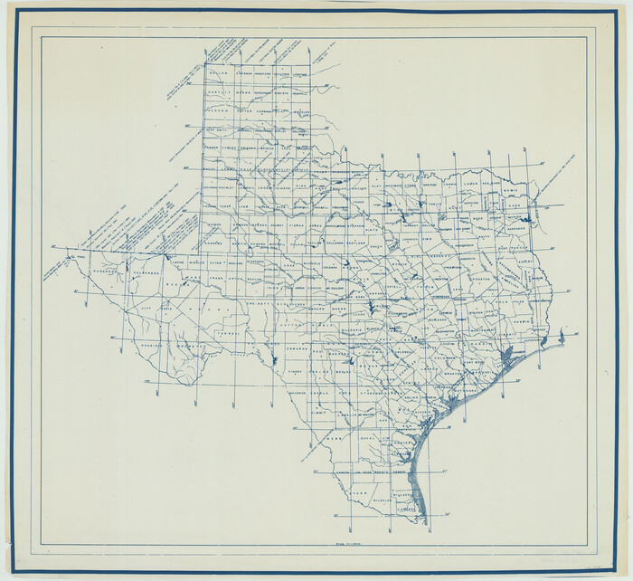
[Triangulation Net of Part of Texas. Travis County to Red River]
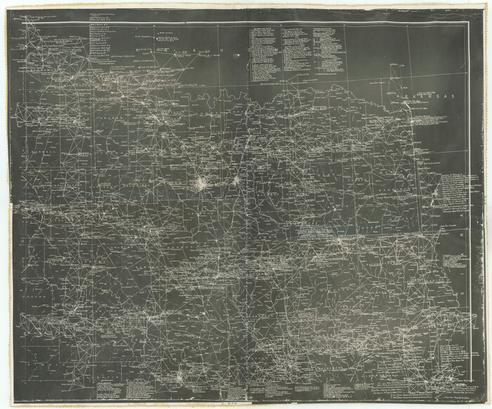
Print $20.00
- Digital $50.00
[Triangulation Net of Part of Texas. Travis County to Red River]
1928
Size: 28.2 x 33.9 inches
3101
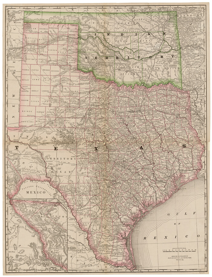
[Rand McNally's Indexed Map of Texas and Indian Territory]
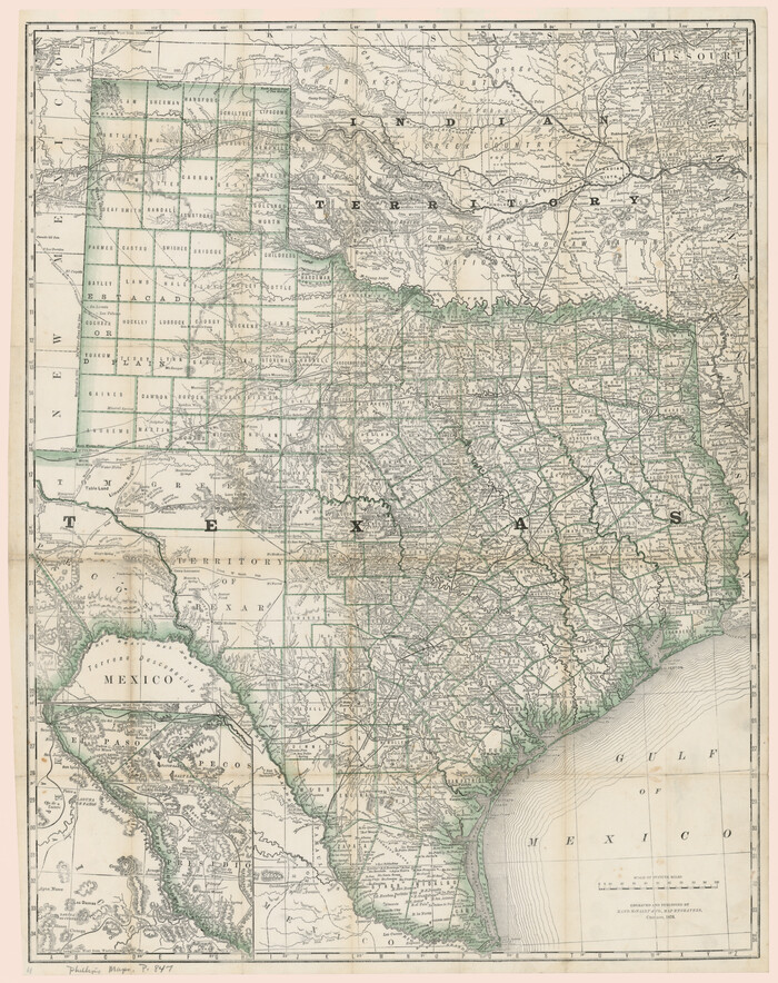
Print $20.00
- Digital $50.00
[Rand McNally's Indexed Map of Texas and Indian Territory]
Size: 26.0 x 20.6 inches
93992
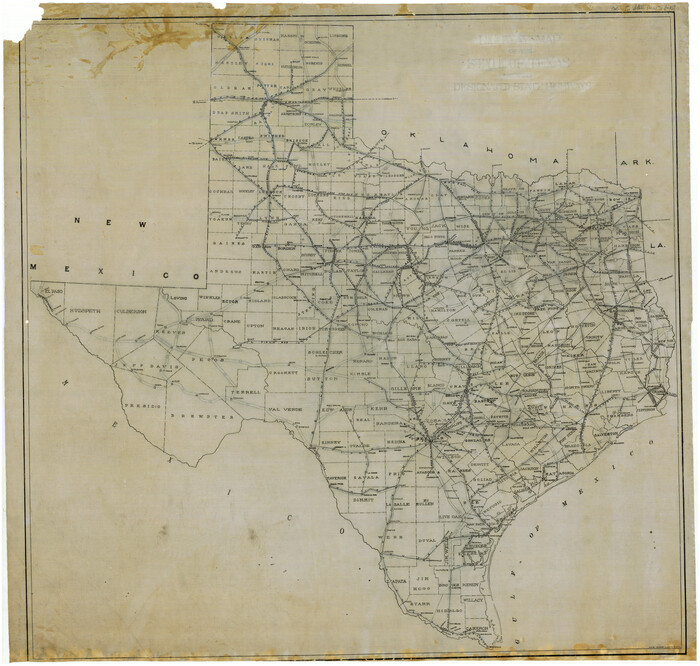
[Map of the Texas & Pacific Railway and connections]
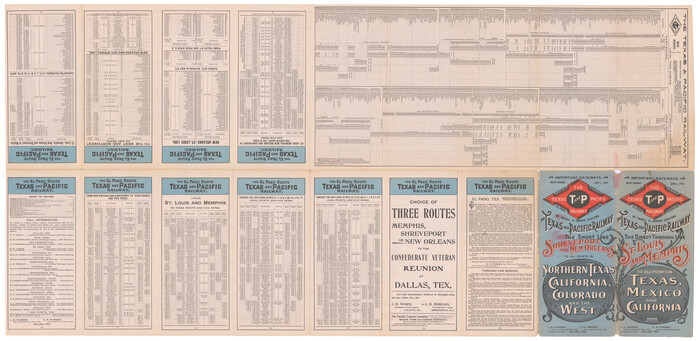
Print $20.00
- Digital $50.00
[Map of the Texas & Pacific Railway and connections]
1902
Size: 18.0 x 37.0 inches
95414
[Map of Texas showing Frisco Lines]
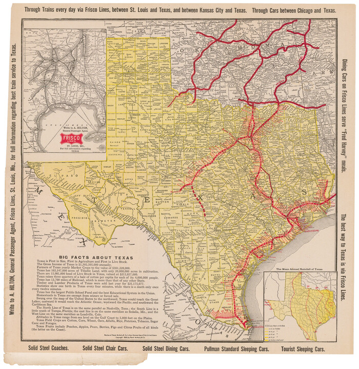
Print $20.00
- Digital $50.00
[Map of Texas showing Frisco Lines]
1910
Size: 19.8 x 19.2 inches
95796
[Map of Texas showing Counties, County Seats, Rivers and Location of State Boundary Line Markers]
Print $20.00
- Digital $50.00
[Map of Texas showing Counties, County Seats, Rivers and Location of State Boundary Line Markers]
1950
Size: 30.2 x 32.9 inches
60304
[Map of Texas and Indian Territory]
Print $20.00
- Digital $50.00
[Map of Texas and Indian Territory]
1878
Size: 26.2 x 20.1 inches
93757
[Highway Map of the State of Texas]
Print $20.00
- Digital $50.00
[Highway Map of the State of Texas]
1923
Size: 44.7 x 46.7 inches
5039
[Gulf Coast portion of] Map of the State of Texas
Print $20.00
- Digital $50.00
[Gulf Coast portion of] Map of the State of Texas
1865
Size: 27.2 x 18.2 inches
72706
[Gulf Coast portion of] Map of the State of Texas
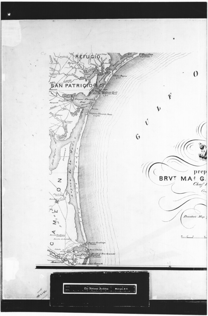
Print $20.00
- Digital $50.00
[Gulf Coast portion of] Map of the State of Texas
1865
Size: 27.4 x 18.1 inches
72707
[Grid Map Showing Texas, Louisiana, Arkansas, Mississippi and portions of New Mexico, Oklahoma and Tennessee]
Print $20.00
- Digital $50.00
[Grid Map Showing Texas, Louisiana, Arkansas, Mississippi and portions of New Mexico, Oklahoma and Tennessee]
1940
Size: 36.4 x 47.3 inches
4668
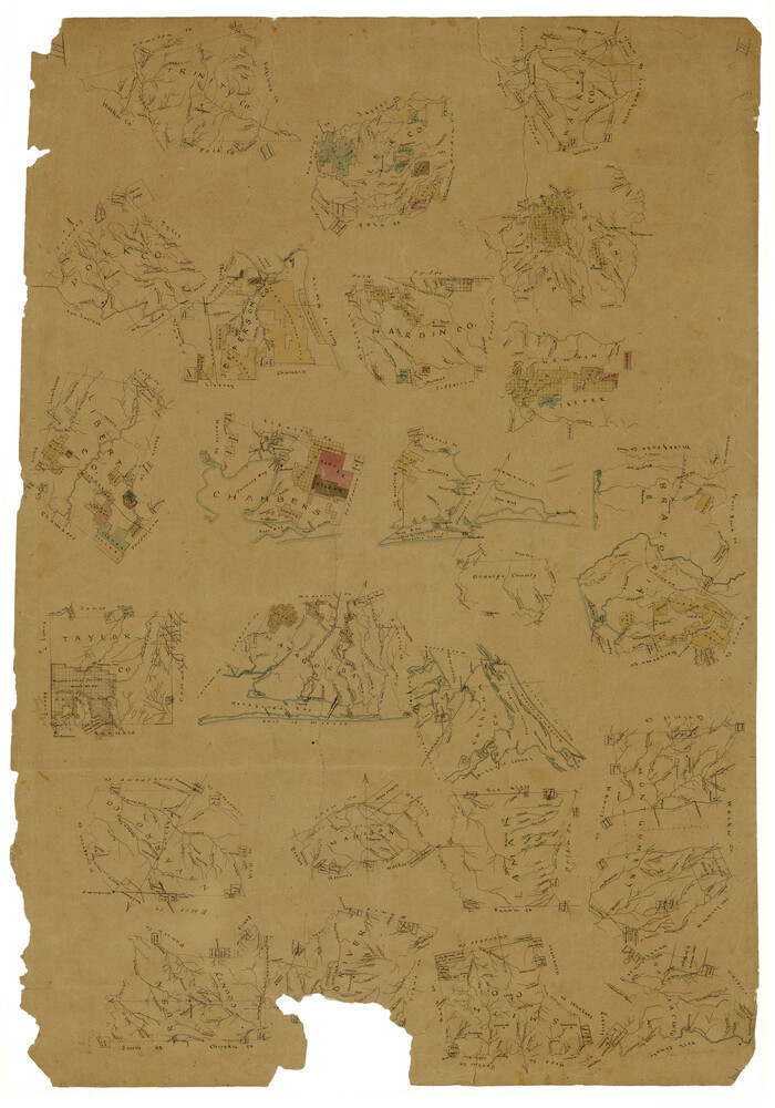
[Drawings of individual counties for Pressler and Langermann's 1879 Map of Texas]
Print $20.00
- Digital $50.00
[Drawings of individual counties for Pressler and Langermann's 1879 Map of Texas]
1878
Size: 28.5 x 42.0 inches
2140
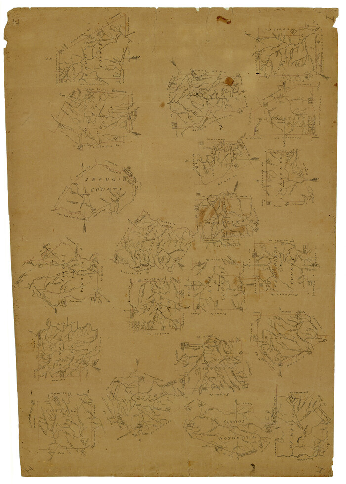
[Drawings of individual counties for Pressler and Langermann's 1879 Map of Texas]
Print $20.00
- Digital $50.00
[Drawings of individual counties for Pressler and Langermann's 1879 Map of Texas]
1878
Size: 38.8 x 26.8 inches
4863
[Drawings of individual counties for Pressler and Langermann's 1879 Map of Texas]
Print $20.00
- Digital $50.00
[Drawings of individual counties for Pressler and Langermann's 1879 Map of Texas]
1878
Size: 38.3 x 26.8 inches
4864
[Drawings of individual counties for Pressler and Langermann's 1879 Map of Texas]
Print $20.00
- Digital $50.00
[Drawings of individual counties for Pressler and Langermann's 1879 Map of Texas]
1878
Size: 27.3 x 38.1 inches
4865
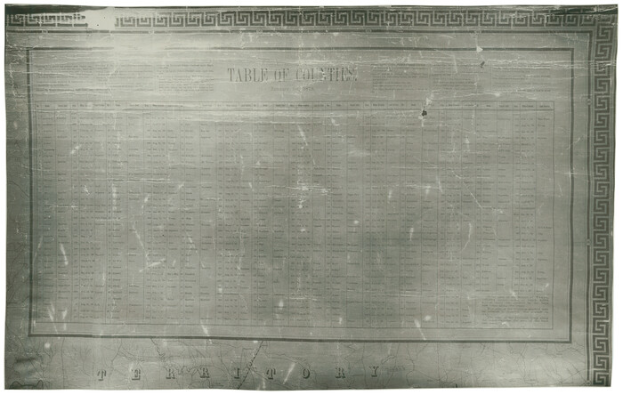
[County table portion of 1879 State of Texas map by Pressler & Langermann]
Print $20.00
- Digital $50.00
[County table portion of 1879 State of Texas map by Pressler & Langermann]
1879
Size: 15.0 x 23.6 inches
3102
West and Trans-Pecos Texas with parts of New Mexico and Mexico and a New Map of Big Bend Ranch State Park and Surrounding Area

Print $32.48
West and Trans-Pecos Texas with parts of New Mexico and Mexico and a New Map of Big Bend Ranch State Park and Surrounding Area
1988
Size: 28.0 x 31.0 inches
89070
Traveller's Map of the State of Texas

Print $20.00
- Digital $50.00
Traveller's Map of the State of Texas
1867
Size: 40.7 x 38.7 inches
2130
Traveller's Map of the State of Texas

Print $20.00
- Digital $50.00
Traveller's Map of the State of Texas
1867
Size: 40.6 x 38.2 inches
4327
Traveller's Map of the State of Texas

Print $20.00
- Digital $50.00
Traveller's Map of the State of Texas
1867
Size: 41.8 x 38.9 inches
4328
Traveller's Map of the State of Texas

Print $20.00
Traveller's Map of the State of Texas
1867
Size: 42.5 x 41.1 inches
76226
Traveller's Map of the State of Texas

Print $20.00
- Digital $50.00
Traveller's Map of the State of Texas
1867
Size: 43.4 x 41.6 inches
93906
Traveller's Map of the State of Texas

Print $20.00
- Digital $50.00
Traveller's Map of the State of Texas
1867
Size: 43.6 x 41.7 inches
93935
Topographisch-geognostische Karte von Texas mit Zugrundelegung der geographischen Karte v. Wilson nach eigenen Beobachtungen bearbeitet von Dr. Ferd. Roemer

Print $20.00
- Digital $50.00
Topographisch-geognostische Karte von Texas mit Zugrundelegung der geographischen Karte v. Wilson nach eigenen Beobachtungen bearbeitet von Dr. Ferd. Roemer
1849
Size: 24.5 x 21.0 inches
94099
Topographisch-geognostische Karte von Texas mit Zugrundelegung der geographischen Karte v. Wilson nach eigenen Beobachtungen bearbeitet von Dr. Ferd. Roemer

Print $20.00
- Digital $50.00
Topographisch-geognostische Karte von Texas mit Zugrundelegung der geographischen Karte v. Wilson nach eigenen Beobachtungen bearbeitet von Dr. Ferd. Roemer
1849
Size: 23.5 x 21.0 inches
96523
Topographisch-geognostische Karte von Texas

Print $20.00
Topographisch-geognostische Karte von Texas
1849
Size: 23.8 x 21.1 inches
76241
The railroad system of Texas on September 1st, 1883

Print $20.00
The railroad system of Texas on September 1st, 1883
1883
Size: 20.1 x 26.8 inches
93618
[Triangulation Net of Part of Texas. Travis County to Red River]
Print $20.00
- Digital $50.00
[Triangulation Net of Part of Texas. Travis County to Red River]
1928
-
Size
28.2 x 33.9 inches
-
Map/Doc
3101
-
Creation Date
1928
[Rand McNally's Indexed Map of Texas and Indian Territory]
Print $20.00
- Digital $50.00
[Rand McNally's Indexed Map of Texas and Indian Territory]
-
Size
26.0 x 20.6 inches
-
Map/Doc
93992
[Metropolitan Areas of Texas]
![96824, [Metropolitan Areas of Texas], General Map Collection](https://historictexasmaps.com/wmedia_w700/maps/96824.tif.jpg)
[Metropolitan Areas of Texas]
1994
-
Size
33.6 x 36.1 inches
-
Map/Doc
96824
-
Creation Date
1994
[Map of the Texas & Pacific Railway and connections]
Print $20.00
- Digital $50.00
[Map of the Texas & Pacific Railway and connections]
1902
-
Size
18.0 x 37.0 inches
-
Map/Doc
95414
-
Creation Date
1902
[Map of Texas]
![95882, [Map of Texas], Cobb Digital Map Collection - 1](https://historictexasmaps.com/wmedia_w700/maps/95882.tif.jpg)
Print $20.00
- Digital $50.00
[Map of Texas]
1908
-
Size
18.5 x 18.7 inches
-
Map/Doc
95882
-
Creation Date
1908
[Map of Texas]
![96624, [Map of Texas], Cobb Digital Map Collection](https://historictexasmaps.com/wmedia_w700/maps/96624.tif.jpg)
Print $20.00
- Digital $50.00
[Map of Texas]
1869
-
Size
9.9 x 8.8 inches
-
Map/Doc
96624
-
Creation Date
1869
[Map of Texas showing Frisco Lines]
Print $20.00
- Digital $50.00
[Map of Texas showing Frisco Lines]
1910
-
Size
19.8 x 19.2 inches
-
Map/Doc
95796
-
Creation Date
1910
[Map of Texas showing Counties, County Seats, Rivers and Location of State Boundary Line Markers]
Print $20.00
- Digital $50.00
[Map of Texas showing Counties, County Seats, Rivers and Location of State Boundary Line Markers]
1950
-
Size
30.2 x 32.9 inches
-
Map/Doc
60304
-
Creation Date
1950
[Map of Texas and Indian Territory]
Print $20.00
- Digital $50.00
[Map of Texas and Indian Territory]
1878
-
Size
26.2 x 20.1 inches
-
Map/Doc
93757
-
Creation Date
1878
[Highway Map of the State of Texas]
Print $20.00
- Digital $50.00
[Highway Map of the State of Texas]
1923
-
Size
44.7 x 46.7 inches
-
Map/Doc
5039
-
Creation Date
1923
[Gulf Coast portion of] Map of the State of Texas
Print $20.00
- Digital $50.00
[Gulf Coast portion of] Map of the State of Texas
1865
-
Size
27.2 x 18.2 inches
-
Map/Doc
72706
-
Creation Date
1865
[Gulf Coast portion of] Map of the State of Texas
Print $20.00
- Digital $50.00
[Gulf Coast portion of] Map of the State of Texas
1865
-
Size
27.4 x 18.1 inches
-
Map/Doc
72707
-
Creation Date
1865
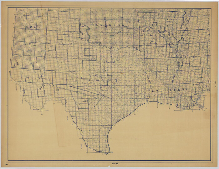
[Grid Map Showing Texas, Louisiana, Arkansas, Mississippi and portions of New Mexico, Oklahoma and Tennessee]
Print $20.00
- Digital $50.00
[Grid Map Showing Texas, Louisiana, Arkansas, Mississippi and portions of New Mexico, Oklahoma and Tennessee]
1940
-
Size
36.4 x 47.3 inches
-
Map/Doc
4668
-
Creation Date
1940
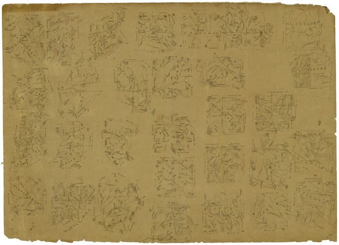
[Drawings of individual counties for Pressler and Langermann's 1879 Map of Texas]
Print $20.00
- Digital $50.00
[Drawings of individual counties for Pressler and Langermann's 1879 Map of Texas]
1878
-
Size
28.5 x 42.0 inches
-
Map/Doc
2140
-
Creation Date
1878
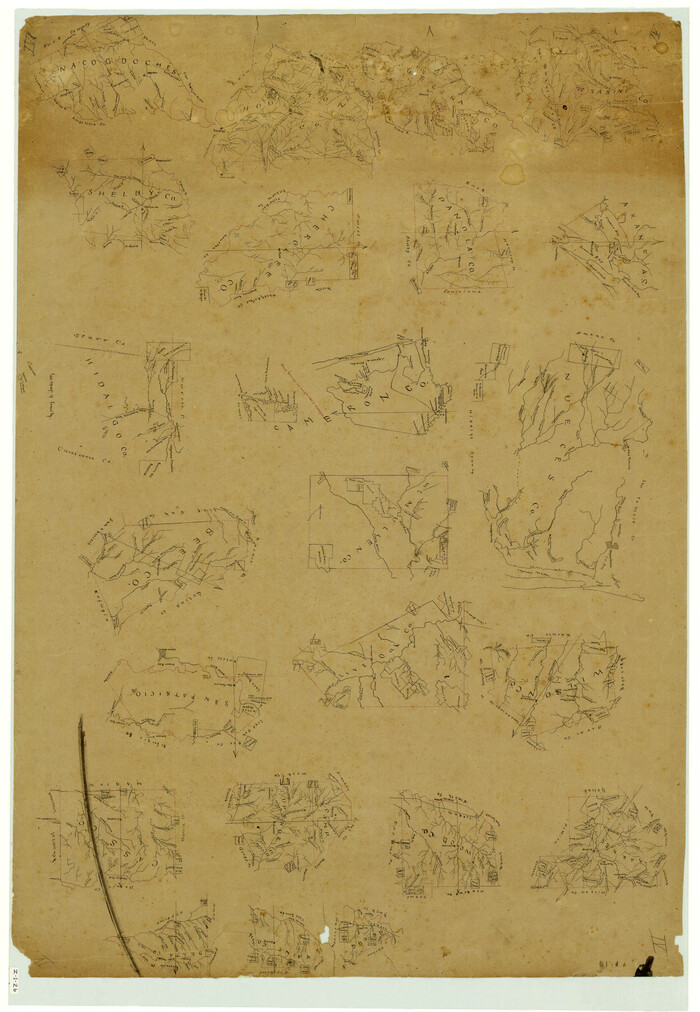
[Drawings of individual counties for Pressler and Langermann's 1879 Map of Texas]
Print $20.00
- Digital $50.00
[Drawings of individual counties for Pressler and Langermann's 1879 Map of Texas]
1878
-
Size
38.8 x 26.8 inches
-
Map/Doc
4863
-
Creation Date
1878
[Drawings of individual counties for Pressler and Langermann's 1879 Map of Texas]
Print $20.00
- Digital $50.00
[Drawings of individual counties for Pressler and Langermann's 1879 Map of Texas]
1878
-
Size
38.3 x 26.8 inches
-
Map/Doc
4864
-
Creation Date
1878
[Drawings of individual counties for Pressler and Langermann's 1879 Map of Texas]
Print $20.00
- Digital $50.00
[Drawings of individual counties for Pressler and Langermann's 1879 Map of Texas]
1878
-
Size
27.3 x 38.1 inches
-
Map/Doc
4865
-
Creation Date
1878
[County table portion of 1879 State of Texas map by Pressler & Langermann]
Print $20.00
- Digital $50.00
[County table portion of 1879 State of Texas map by Pressler & Langermann]
1879
-
Size
15.0 x 23.6 inches
-
Map/Doc
3102
-
Creation Date
1879
Where to Emigrate and Why

Where to Emigrate and Why
1869
-
Size
9.3 x 6.5 inches
-
Map/Doc
96610
-
Creation Date
1869
West and Trans-Pecos Texas with parts of New Mexico and Mexico and a New Map of Big Bend Ranch State Park and Surrounding Area
Print $32.48
West and Trans-Pecos Texas with parts of New Mexico and Mexico and a New Map of Big Bend Ranch State Park and Surrounding Area
1988
-
Size
28.0 x 31.0 inches
-
Map/Doc
89070
-
Creation Date
1988
Traveller's Map of the State of Texas
Print $20.00
- Digital $50.00
Traveller's Map of the State of Texas
1867
-
Size
40.7 x 38.7 inches
-
Map/Doc
2130
-
Creation Date
1867
Traveller's Map of the State of Texas
Print $20.00
- Digital $50.00
Traveller's Map of the State of Texas
1867
-
Size
40.6 x 38.2 inches
-
Map/Doc
4327
-
Creation Date
1867
Traveller's Map of the State of Texas
Print $20.00
- Digital $50.00
Traveller's Map of the State of Texas
1867
-
Size
41.8 x 38.9 inches
-
Map/Doc
4328
-
Creation Date
1867
Traveller's Map of the State of Texas
Print $20.00
Traveller's Map of the State of Texas
1867
-
Size
42.5 x 41.1 inches
-
Map/Doc
76226
-
Creation Date
1867
Traveller's Map of the State of Texas
Print $20.00
- Digital $50.00
Traveller's Map of the State of Texas
1867
-
Size
43.4 x 41.6 inches
-
Map/Doc
93906
-
Creation Date
1867
Traveller's Map of the State of Texas
Print $20.00
- Digital $50.00
Traveller's Map of the State of Texas
1867
-
Size
43.6 x 41.7 inches
-
Map/Doc
93935
-
Creation Date
1867
Topographisch-geognostische Karte von Texas mit Zugrundelegung der geographischen Karte v. Wilson nach eigenen Beobachtungen bearbeitet von Dr. Ferd. Roemer
Print $20.00
- Digital $50.00
Topographisch-geognostische Karte von Texas mit Zugrundelegung der geographischen Karte v. Wilson nach eigenen Beobachtungen bearbeitet von Dr. Ferd. Roemer
1849
-
Size
24.5 x 21.0 inches
-
Map/Doc
94099
-
Creation Date
1849
Topographisch-geognostische Karte von Texas mit Zugrundelegung der geographischen Karte v. Wilson nach eigenen Beobachtungen bearbeitet von Dr. Ferd. Roemer
Print $20.00
- Digital $50.00
Topographisch-geognostische Karte von Texas mit Zugrundelegung der geographischen Karte v. Wilson nach eigenen Beobachtungen bearbeitet von Dr. Ferd. Roemer
1849
-
Size
23.5 x 21.0 inches
-
Map/Doc
96523
-
Creation Date
1849
Topographisch-geognostische Karte von Texas
Print $20.00
Topographisch-geognostische Karte von Texas
1849
-
Size
23.8 x 21.1 inches
-
Map/Doc
76241
-
Creation Date
1849
The railroad system of Texas on September 1st, 1883
Print $20.00
The railroad system of Texas on September 1st, 1883
1883
-
Size
20.1 x 26.8 inches
-
Map/Doc
93618
-
Creation Date
1883