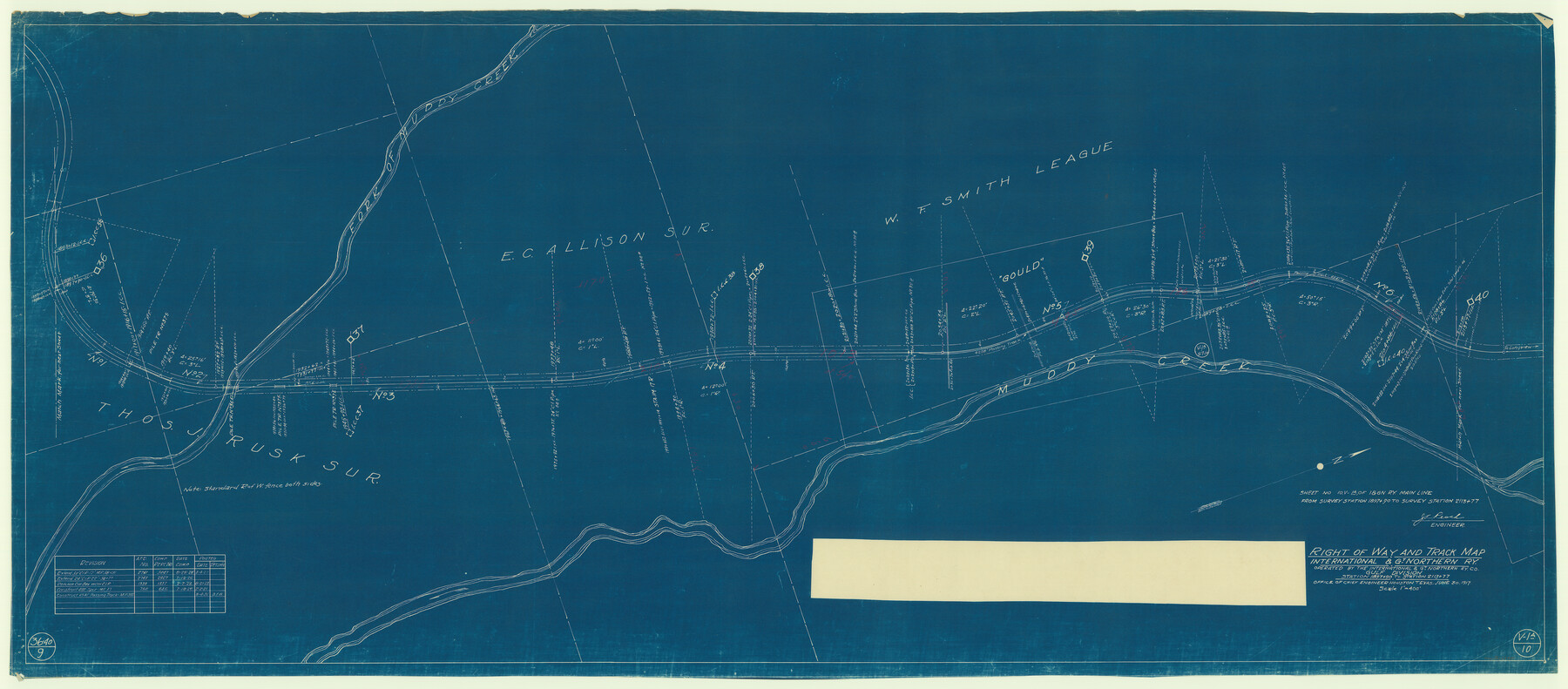
Right of Way and Track Map, International & Gt. Northern Ry. Operated by the International & Gt. Northern Ry. Co., Gulf Division
Station 1897+90 to Station 2113+77
Z-2-62
-
Map/Doc
64251
-
Collection
General Map Collection
-
Object Dates
1927/3/4 (Revision Date)
1923/8/21 (Revision Date)
1921/2/2 (Revision Date)
1931/8/4 (Revision Date)
1917/6/30 (Creation Date)
-
People and Organizations
Office of Chief Engineer (Publisher)
J.C. Resch (Surveyor/Engineer)
-
Counties
Cherokee
-
Subjects
Railroads
-
Height x Width
24.8 x 56.5 inches
63.0 x 143.5 cm
-
Medium
blueprint/diazo
-
Scale
1" = 400'
-
Comments
See counter nos. 64245 through 64253 for all sheets of this map.
-
Features
I&GN
Gould
Muddy Creek
Part of: General Map Collection

Hutchinson County Sketch File 23

Print $22.00
- Digital $50.00
Hutchinson County Sketch File 23
1913
Size 11.2 x 8.8 inches
Map/Doc 27245
Mills County Rolled Sketch 6

Print $20.00
- Digital $50.00
Mills County Rolled Sketch 6
2007
Size 24.4 x 36.6 inches
Map/Doc 88738
Bexar County Sketch File 36b

Print $40.00
- Digital $50.00
Bexar County Sketch File 36b
Size 18.6 x 20.2 inches
Map/Doc 10921
Township No. 5 South Range No. 12 West of the Indian Meridian

Print $4.00
- Digital $50.00
Township No. 5 South Range No. 12 West of the Indian Meridian
1875
Size 18.1 x 22.6 inches
Map/Doc 75159
Pecos County Rolled Sketch 167

Print $20.00
- Digital $50.00
Pecos County Rolled Sketch 167
1886
Size 41.1 x 27.1 inches
Map/Doc 7291
Flight Mission No. BRA-8M, Frame 134, Jefferson County

Print $20.00
- Digital $50.00
Flight Mission No. BRA-8M, Frame 134, Jefferson County
1953
Size 18.6 x 22.5 inches
Map/Doc 85630
Haskell County Working Sketch 15

Print $40.00
- Digital $50.00
Haskell County Working Sketch 15
1983
Size 48.0 x 57.5 inches
Map/Doc 66073
Uvalde County Sketch File 31

Print $4.00
- Digital $50.00
Uvalde County Sketch File 31
Size 11.2 x 8.8 inches
Map/Doc 81529
Parker County Sketch File 6

Print $6.00
- Digital $50.00
Parker County Sketch File 6
1858
Size 6.9 x 6.0 inches
Map/Doc 33530
Henderson County Sketch File 20

Print $20.00
- Digital $50.00
Henderson County Sketch File 20
Size 23.7 x 23.5 inches
Map/Doc 11757
Neches River, Blackburn Bridge Dam Site

Print $2.00
- Digital $50.00
Neches River, Blackburn Bridge Dam Site
1938
Size 15.4 x 17.6 inches
Map/Doc 65082
You may also like
Revised Sectional Map showing land surveys in counties of Loving and Reeves

Print $20.00
- Digital $50.00
Revised Sectional Map showing land surveys in counties of Loving and Reeves
Size 18.0 x 17.7 inches
Map/Doc 5053
Hardin County Rolled Sketch 22

Print $20.00
- Digital $50.00
Hardin County Rolled Sketch 22
1977
Size 32.0 x 44.4 inches
Map/Doc 9110
Culberson County Working Sketch 47

Print $20.00
- Digital $50.00
Culberson County Working Sketch 47
1971
Size 25.7 x 36.5 inches
Map/Doc 68501
Controlled Mosaic by Jack Amman Photogrammetric Engineers, Inc - Sheet 34

Print $20.00
- Digital $50.00
Controlled Mosaic by Jack Amman Photogrammetric Engineers, Inc - Sheet 34
1954
Size 20.0 x 24.0 inches
Map/Doc 83487
Leon County Working Sketch 61

Print $20.00
- Digital $50.00
Leon County Working Sketch 61
2010
Size 35.8 x 38.7 inches
Map/Doc 89986
Pecos County Sketch File U

Print $20.00
- Digital $50.00
Pecos County Sketch File U
1902
Size 20.9 x 32.7 inches
Map/Doc 12188
Refugio County Boundary File 1

Print $6.00
- Digital $50.00
Refugio County Boundary File 1
Size 8.1 x 3.4 inches
Map/Doc 58225
Map of Hamilton County

Print $20.00
- Digital $50.00
Map of Hamilton County
1872
Size 15.1 x 22.1 inches
Map/Doc 4555
Map of Liberty County Texas

Print $20.00
- Digital $50.00
Map of Liberty County Texas
1879
Size 24.2 x 23.9 inches
Map/Doc 3814
Map showing the environs of Brazos Island, Texas

Print $20.00
- Digital $50.00
Map showing the environs of Brazos Island, Texas
Size 18.2 x 25.0 inches
Map/Doc 72925

Austin County Sketch File 8

Print $40.00
- Digital $50.00
Austin County Sketch File 8
1894
Size 19.3 x 19.9 inches
Map/Doc 10873