Water-Shed of the Pease River Drainage Area

Print $6.00
- Digital $50.00
Water-Shed of the Pease River Drainage Area
Size: 14.9 x 31.0 inches
65102
Sabine River, Watershed of the Sabine and Neches Rivers

Print $20.00
- Digital $50.00
Sabine River, Watershed of the Sabine and Neches Rivers
Size: 39.5 x 36.0 inches
65132
Sabine River, Composite Sheet

Print $40.00
- Digital $50.00
Sabine River, Composite Sheet
Size: 38.5 x 52.7 inches
65133
Sabine River, Rocky Point Crossing Sheet

Print $4.00
- Digital $50.00
Sabine River, Rocky Point Crossing Sheet
Size: 24.0 x 24.6 inches
65134
Sabine River, Kane Bridge Sheet

Print $4.00
- Digital $50.00
Sabine River, Kane Bridge Sheet
Size: 20.9 x 24.2 inches
65135
San Jacinto River, Water Sheds of the San Jacinto River and Buffalo Bayou

Print $4.00
- Digital $50.00
San Jacinto River, Water Sheds of the San Jacinto River and Buffalo Bayou
Size: 28.8 x 20.0 inches
65149
Texas-Oklahoma Paris Quadrangle

Print $20.00
- Digital $50.00
Texas-Oklahoma Paris Quadrangle
Size: 22.3 x 18.4 inches
75107
Texas-Oklahoma Clarksville Quadrangle

Print $20.00
- Digital $50.00
Texas-Oklahoma Clarksville Quadrangle
Size: 22.2 x 18.3 inches
75109
Geological Survey of Texas, First Annual Report, Plate II, Figures 6, 7, 8, 9

Print $20.00
- Digital $50.00
Geological Survey of Texas, First Annual Report, Plate II, Figures 6, 7, 8, 9
Size: 17.1 x 18.1 inches
75114
In the Supreme Court of the United States, The State of Oklahoma, Complainant vs. The State of Texas, Defendant, The United States of America, Intervener, Red River Valley, Texas and Oklahoma Between the 98th and 100th Meridians in Five Sheets, 1921

Print $40.00
- Digital $50.00
In the Supreme Court of the United States, The State of Oklahoma, Complainant vs. The State of Texas, Defendant, The United States of America, Intervener, Red River Valley, Texas and Oklahoma Between the 98th and 100th Meridians in Five Sheets, 1921
Size: 38.3 x 60.1 inches
75279
Sulphur River, Bexelder Sheet/Cuthand Creek

Print $20.00
- Digital $50.00
Sulphur River, Bexelder Sheet/Cuthand Creek
Size: 17.3 x 14.1 inches
78325
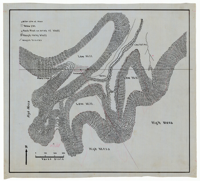
[Sketch showing topography in vicinity of Yellow Point]
Print $20.00
- Digital $50.00
[Sketch showing topography in vicinity of Yellow Point]
Size: 21.4 x 19.2 inches
92137
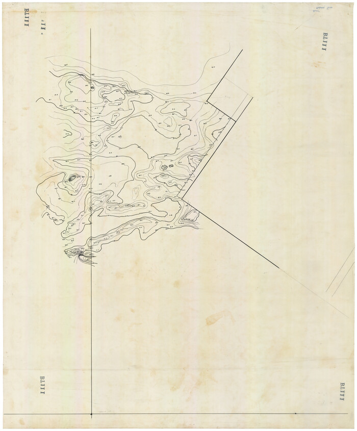
[Topographical Map]
Print $20.00
- Digital $50.00
[Topographical Map]
Size: 31.2 x 37.5 inches
92543
Abernathy Quadrangle

Print $20.00
- Digital $50.00
Abernathy Quadrangle
Size: 17.6 x 21.4 inches
92813
Topographisch-geognostische Karte von Texas

Print $20.00
Topographisch-geognostische Karte von Texas
1849
Size: 23.8 x 21.1 inches
76241
Reconnoissance of Sabine River and Vicinty

Print $20.00
Reconnoissance of Sabine River and Vicinty
1863
Size: 30.4 x 42.3 inches
97497
Reconnoissance of Sabine River and Valley

Print $20.00
Reconnoissance of Sabine River and Valley
1863
Size: 30.4 x 42.5 inches
97498
Reconnoissance of Sabine River and Valley

Print $20.00
Reconnoissance of Sabine River and Valley
1863
Size: 30.2 x 42.3 inches
97499
Reconnoissance of Sabine River and Valley

Print $20.00
Reconnoissance of Sabine River and Valley
1863
Size: 42.5 x 30.3 inches
97500
Reconnoissance of Sabine River and Valley

Print $20.00
Reconnoissance of Sabine River and Valley
1863
Size: 42.3 x 30.0 inches
97501
Topographical Map of the country between San Antonio & Colorado Rivers in the State of Texas.

Print $40.00
Topographical Map of the country between San Antonio & Colorado Rivers in the State of Texas.
1864
Size: 53.3 x 69.2 inches
88604
Topographical Map of the country between San Antonio & Colorado Rivers in the State of Texas.

Print $40.00
Topographical Map of the country between San Antonio & Colorado Rivers in the State of Texas.
1864
Size: 53.4 x 69.8 inches
88605
Topographical Map of the country between San Antonio & Colorado Rivers in the State of Texas.

Print $40.00
Topographical Map of the country between San Antonio & Colorado Rivers in the State of Texas.
1864
Size: 53.2 x 74.8 inches
88606
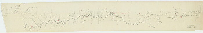
[Traverse up the Brazos and Colorado River showing distance from county site to county site]
Print $40.00
- Digital $50.00
[Traverse up the Brazos and Colorado River showing distance from county site to county site]
1871
Size: 16.2 x 98.8 inches
2054
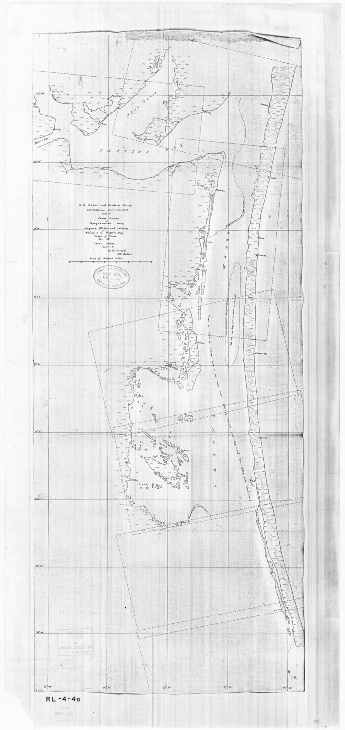
Sketch showing progress of topographical work Laguna Madre and vicinity from Rainey Is. to Baffins Bay, Coast of Texas Sect. IX [and accompanying letter]
Print $20.00
- Digital $50.00
Sketch showing progress of topographical work Laguna Madre and vicinity from Rainey Is. to Baffins Bay, Coast of Texas Sect. IX [and accompanying letter]
1880
Size: 39.2 x 18.6 inches
72957
Topography and water depth as shown by the U.S. Coast Survey of 1888

Print $20.00
- Digital $50.00
Topography and water depth as shown by the U.S. Coast Survey of 1888
1890
Size: 17.0 x 18.8 inches
390
General Topographical Map. Sheet XXII

Print $20.00
- Digital $50.00
General Topographical Map. Sheet XXII
1891
Size: 18.4 x 29.4 inches
97526
Map of Harris County

Print $20.00
- Digital $50.00
Map of Harris County
1893
Size: 26.6 x 34.4 inches
65810
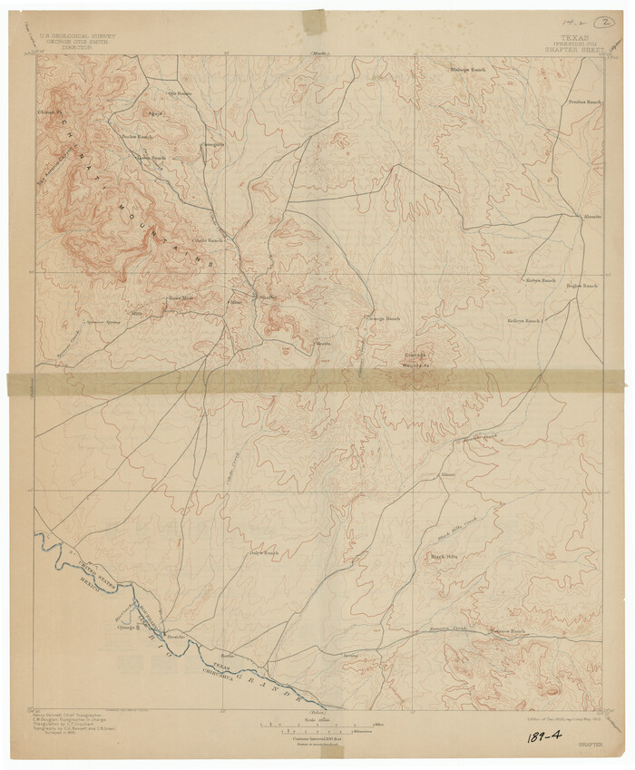
[USGS Topo Quad map of Shafter Sheet, Presidio County]
Print $20.00
- Digital $50.00
[USGS Topo Quad map of Shafter Sheet, Presidio County]
1895
Size: 16.9 x 20.5 inches
91754
Jeff Davis County Rolled Sketch 15

Print $20.00
- Digital $50.00
Jeff Davis County Rolled Sketch 15
1897
Size: 20.4 x 17.2 inches
6368
Water-Shed of the Pease River Drainage Area
Print $6.00
- Digital $50.00
Water-Shed of the Pease River Drainage Area
-
Size
14.9 x 31.0 inches
-
Map/Doc
65102
Sabine River, Watershed of the Sabine and Neches Rivers
Print $20.00
- Digital $50.00
Sabine River, Watershed of the Sabine and Neches Rivers
-
Size
39.5 x 36.0 inches
-
Map/Doc
65132
Sabine River, Composite Sheet
Print $40.00
- Digital $50.00
Sabine River, Composite Sheet
-
Size
38.5 x 52.7 inches
-
Map/Doc
65133
Sabine River, Rocky Point Crossing Sheet
Print $4.00
- Digital $50.00
Sabine River, Rocky Point Crossing Sheet
-
Size
24.0 x 24.6 inches
-
Map/Doc
65134
Sabine River, Kane Bridge Sheet
Print $4.00
- Digital $50.00
Sabine River, Kane Bridge Sheet
-
Size
20.9 x 24.2 inches
-
Map/Doc
65135
San Jacinto River, Water Sheds of the San Jacinto River and Buffalo Bayou
Print $4.00
- Digital $50.00
San Jacinto River, Water Sheds of the San Jacinto River and Buffalo Bayou
-
Size
28.8 x 20.0 inches
-
Map/Doc
65149
Texas-Oklahoma Paris Quadrangle
Print $20.00
- Digital $50.00
Texas-Oklahoma Paris Quadrangle
-
Size
22.3 x 18.4 inches
-
Map/Doc
75107
Texas-Oklahoma Clarksville Quadrangle
Print $20.00
- Digital $50.00
Texas-Oklahoma Clarksville Quadrangle
-
Size
22.2 x 18.3 inches
-
Map/Doc
75109
Geological Survey of Texas, First Annual Report, Plate II, Figures 6, 7, 8, 9
Print $20.00
- Digital $50.00
Geological Survey of Texas, First Annual Report, Plate II, Figures 6, 7, 8, 9
-
Size
17.1 x 18.1 inches
-
Map/Doc
75114
In the Supreme Court of the United States, The State of Oklahoma, Complainant vs. The State of Texas, Defendant, The United States of America, Intervener, Red River Valley, Texas and Oklahoma Between the 98th and 100th Meridians in Five Sheets, 1921
Print $40.00
- Digital $50.00
In the Supreme Court of the United States, The State of Oklahoma, Complainant vs. The State of Texas, Defendant, The United States of America, Intervener, Red River Valley, Texas and Oklahoma Between the 98th and 100th Meridians in Five Sheets, 1921
-
Size
38.3 x 60.1 inches
-
Map/Doc
75279
Sulphur River, Bexelder Sheet/Cuthand Creek
Print $20.00
- Digital $50.00
Sulphur River, Bexelder Sheet/Cuthand Creek
-
Size
17.3 x 14.1 inches
-
Map/Doc
78325
[Sketch showing topography in vicinity of Yellow Point]
Print $20.00
- Digital $50.00
[Sketch showing topography in vicinity of Yellow Point]
-
Size
21.4 x 19.2 inches
-
Map/Doc
92137
[Topographical Map]
Print $20.00
- Digital $50.00
[Topographical Map]
-
Size
31.2 x 37.5 inches
-
Map/Doc
92543
Abernathy Quadrangle
Print $20.00
- Digital $50.00
Abernathy Quadrangle
-
Size
17.6 x 21.4 inches
-
Map/Doc
92813
Topographisch-geognostische Karte von Texas
Print $20.00
Topographisch-geognostische Karte von Texas
1849
-
Size
23.8 x 21.1 inches
-
Map/Doc
76241
-
Creation Date
1849
Reconnoissance of Sabine River and Vicinty
Print $20.00
Reconnoissance of Sabine River and Vicinty
1863
-
Size
30.4 x 42.3 inches
-
Map/Doc
97497
-
Creation Date
1863
Reconnoissance of Sabine River and Valley
Print $20.00
Reconnoissance of Sabine River and Valley
1863
-
Size
30.4 x 42.5 inches
-
Map/Doc
97498
-
Creation Date
1863
Reconnoissance of Sabine River and Valley
Print $20.00
Reconnoissance of Sabine River and Valley
1863
-
Size
30.2 x 42.3 inches
-
Map/Doc
97499
-
Creation Date
1863
Reconnoissance of Sabine River and Valley
Print $20.00
Reconnoissance of Sabine River and Valley
1863
-
Size
42.5 x 30.3 inches
-
Map/Doc
97500
-
Creation Date
1863
Reconnoissance of Sabine River and Valley
Print $20.00
Reconnoissance of Sabine River and Valley
1863
-
Size
42.3 x 30.0 inches
-
Map/Doc
97501
-
Creation Date
1863
Topographical Map of the country between San Antonio & Colorado Rivers in the State of Texas.
Print $40.00
Topographical Map of the country between San Antonio & Colorado Rivers in the State of Texas.
1864
-
Size
53.3 x 69.2 inches
-
Map/Doc
88604
-
Creation Date
1864
Topographical Map of the country between San Antonio & Colorado Rivers in the State of Texas.
Print $40.00
Topographical Map of the country between San Antonio & Colorado Rivers in the State of Texas.
1864
-
Size
53.4 x 69.8 inches
-
Map/Doc
88605
-
Creation Date
1864
Topographical Map of the country between San Antonio & Colorado Rivers in the State of Texas.
Print $40.00
Topographical Map of the country between San Antonio & Colorado Rivers in the State of Texas.
1864
-
Size
53.2 x 74.8 inches
-
Map/Doc
88606
-
Creation Date
1864
[Traverse up the Brazos and Colorado River showing distance from county site to county site]
Print $40.00
- Digital $50.00
[Traverse up the Brazos and Colorado River showing distance from county site to county site]
1871
-
Size
16.2 x 98.8 inches
-
Map/Doc
2054
-
Creation Date
1871
Sketch showing progress of topographical work Laguna Madre and vicinity from Rainey Is. to Baffins Bay, Coast of Texas Sect. IX [and accompanying letter]
Print $20.00
- Digital $50.00
Sketch showing progress of topographical work Laguna Madre and vicinity from Rainey Is. to Baffins Bay, Coast of Texas Sect. IX [and accompanying letter]
1880
-
Size
39.2 x 18.6 inches
-
Map/Doc
72957
-
Creation Date
1880
Topography and water depth as shown by the U.S. Coast Survey of 1888
Print $20.00
- Digital $50.00
Topography and water depth as shown by the U.S. Coast Survey of 1888
1890
-
Size
17.0 x 18.8 inches
-
Map/Doc
390
-
Creation Date
1890
General Topographical Map. Sheet XXII
Print $20.00
- Digital $50.00
General Topographical Map. Sheet XXII
1891
-
Size
18.4 x 29.4 inches
-
Map/Doc
97526
-
Creation Date
1891
Map of Harris County
Print $20.00
- Digital $50.00
Map of Harris County
1893
-
Size
26.6 x 34.4 inches
-
Map/Doc
65810
-
Creation Date
1893
[USGS Topo Quad map of Shafter Sheet, Presidio County]
Print $20.00
- Digital $50.00
[USGS Topo Quad map of Shafter Sheet, Presidio County]
1895
-
Size
16.9 x 20.5 inches
-
Map/Doc
91754
-
Creation Date
1895
Jeff Davis County Rolled Sketch 15
Print $20.00
- Digital $50.00
Jeff Davis County Rolled Sketch 15
1897
-
Size
20.4 x 17.2 inches
-
Map/Doc
6368
-
Creation Date
1897