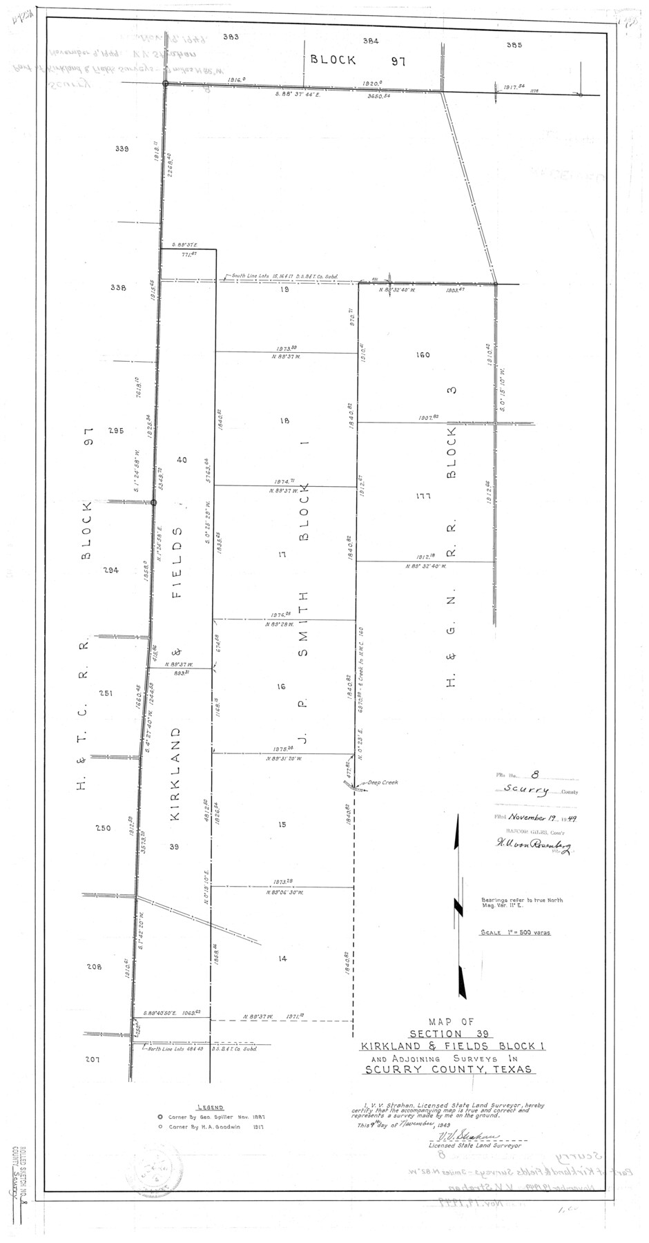
Scurry County Rolled Sketch 8
Map of section 39, Kirkland & Fields Block 1 and adjoining surveys in Scurry County, Texas
-
Map/Doc
7768
-
Collection
General Map Collection
-
Object Dates
11/9/1949 (Creation Date)
11/19/1949 (File Date)
-
People and Organizations
V.V. Strahan (Surveyor/Engineer)
-
Counties
Scurry
-
Subjects
Surveying Rolled Sketch
-
Height x Width
35.1 x 19.1 inches
89.2 x 48.5 cm
-
Scale
1" = 500 varas
Part of: General Map Collection
Sutton County Sketch File 5

Print $40.00
- Digital $50.00
Sutton County Sketch File 5
Size 14.0 x 17.3 inches
Map/Doc 37356
[Sketch for Mineral Application 24072, San Jacinto River]
![65605, [Sketch for Mineral Application 24072, San Jacinto River], General Map Collection](https://historictexasmaps.com/wmedia_w700/maps/65605.tif.jpg)
Print $20.00
- Digital $50.00
[Sketch for Mineral Application 24072, San Jacinto River]
1929
Size 23.4 x 17.8 inches
Map/Doc 65605
Dawson County Rolled Sketch 3

Print $20.00
- Digital $50.00
Dawson County Rolled Sketch 3
1903
Size 20.9 x 36.8 inches
Map/Doc 8770
Preliminary survey of the entrance to the Rio Grande, Texas

Print $20.00
- Digital $50.00
Preliminary survey of the entrance to the Rio Grande, Texas
1854
Size 18.3 x 24.5 inches
Map/Doc 73005
Frio County Rolled Sketch 17

Print $20.00
- Digital $50.00
Frio County Rolled Sketch 17
1953
Size 32.4 x 44.5 inches
Map/Doc 8907
Township No. 1 North Range No. 27 West Indian Meridian

Print $20.00
- Digital $50.00
Township No. 1 North Range No. 27 West Indian Meridian
1875
Size 19.3 x 24.6 inches
Map/Doc 75170
Dallas County Sketch File 2

Print $8.00
- Digital $50.00
Dallas County Sketch File 2
1855
Size 5.6 x 4.5 inches
Map/Doc 20396
Brewster County Rolled Sketch 145

Print $20.00
- Digital $50.00
Brewster County Rolled Sketch 145
1944
Size 24.1 x 18.5 inches
Map/Doc 5312
Victoria County Working Sketch Graphic Index

Print $20.00
- Digital $50.00
Victoria County Working Sketch Graphic Index
1921
Size 47.0 x 39.0 inches
Map/Doc 76728
Brazoria County Rolled Sketch 38

Print $20.00
- Digital $50.00
Brazoria County Rolled Sketch 38
1949
Size 44.6 x 39.5 inches
Map/Doc 8460

Aransas Pass to Baffin Bay

Print $20.00
- Digital $50.00
Aransas Pass to Baffin Bay
1971
Size 42.3 x 35.2 inches
Map/Doc 73417
You may also like
Pecos County Working Sketch 120

Print $20.00
- Digital $50.00
Pecos County Working Sketch 120
1973
Size 34.7 x 29.1 inches
Map/Doc 71593
[Sketch for Mineral Application 11318 - Arenosa Creek, S. G. Drushel]
![65647, [Sketch for Mineral Application 11318 - Arenosa Creek, S. G. Drushel], General Map Collection](https://historictexasmaps.com/wmedia_w700/maps/65647-1.tif.jpg)
Print $40.00
- Digital $50.00
[Sketch for Mineral Application 11318 - Arenosa Creek, S. G. Drushel]
Size 78.9 x 24.8 inches
Map/Doc 65647
Carte Generale des Treize Etats-Unis de l'Amerique Septentrionale

Print $20.00
- Digital $50.00
Carte Generale des Treize Etats-Unis de l'Amerique Septentrionale
1783
Size 22.9 x 27.0 inches
Map/Doc 93678
Palo Pinto County Sketch File 28

Print $8.00
- Digital $50.00
Palo Pinto County Sketch File 28
1875
Size 11.3 x 8.6 inches
Map/Doc 33437
Hansford County Boundary File 1

Print $24.00
- Digital $50.00
Hansford County Boundary File 1
Size 9.2 x 8.6 inches
Map/Doc 54232
Newton County Working Sketch 43

Print $20.00
- Digital $50.00
Newton County Working Sketch 43
1982
Size 20.7 x 28.6 inches
Map/Doc 71289
Titus County Sketch File 11

Print $4.00
- Digital $50.00
Titus County Sketch File 11
1872
Size 8.2 x 10.1 inches
Map/Doc 38150

Atascosa County Sketch File 19

Print $6.00
- Digital $50.00
Atascosa County Sketch File 19
1854
Size 8.8 x 7.2 inches
Map/Doc 13784
Culberson County Working Sketch 58

Print $20.00
- Digital $50.00
Culberson County Working Sketch 58
1974
Size 45.2 x 35.1 inches
Map/Doc 68512
Galveston County NRC Article 33.136 Sketch 42

Print $26.00
- Digital $50.00
Galveston County NRC Article 33.136 Sketch 42
2006
Size 22.1 x 33.7 inches
Map/Doc 83070
Rains County Rolled Sketch 3

Print $40.00
- Digital $50.00
Rains County Rolled Sketch 3
1992
Size 56.2 x 38.4 inches
Map/Doc 8353