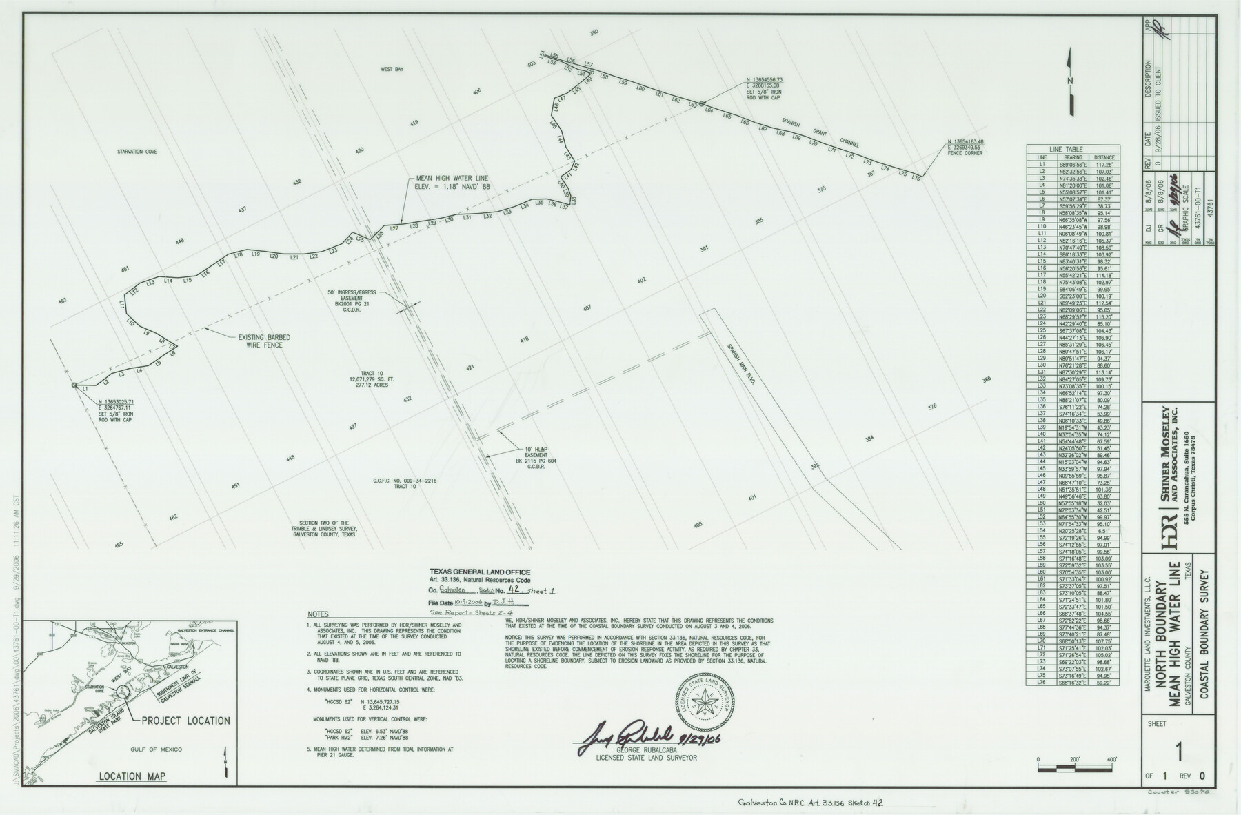
Galveston County NRC Article 33.136 Sketch 42
A Survey of Mean High Water Line South of Starvation Cove
-
Map/Doc
83070
-
Collection
General Map Collection
-
Object Dates
2006/9/29 (Creation Date)
2006/10/9 (File Date)
-
People and Organizations
Shiner Moseley & Associates, Inc. (Publisher)
Shiner Moseley & Associates, Inc. (Printer)
George Rubalcaba (Surveyor/Engineer)
-
Counties
Galveston
-
Subjects
Surveying CBS
-
Height x Width
22.1 x 33.7 inches
56.1 x 85.6 cm
-
Medium
multi-page, multi-format
-
Comments
Survey located about 10 1/2 miles South 64 degrees West of Galveston, Texas.
Part of: General Map Collection
Lee County Working Sketch 13

Print $20.00
- Digital $50.00
Lee County Working Sketch 13
1981
Size 33.4 x 35.7 inches
Map/Doc 70392
Childress County Sketch File 15a

Print $4.00
- Digital $50.00
Childress County Sketch File 15a
Size 8.6 x 11.7 inches
Map/Doc 18303
Van Zandt County Sketch File 41

Print $13.00
- Digital $50.00
Van Zandt County Sketch File 41
Size 12.8 x 8.5 inches
Map/Doc 39489
Sabine County Sketch File 11

Print $4.00
Sabine County Sketch File 11
Size 6.2 x 8.3 inches
Map/Doc 35629
Polk County Working Sketch 5

Print $20.00
- Digital $50.00
Polk County Working Sketch 5
1926
Size 17.9 x 23.2 inches
Map/Doc 71620
Brewster County Sketch File 47

Print $12.00
- Digital $50.00
Brewster County Sketch File 47
1939
Size 14.1 x 8.8 inches
Map/Doc 16321
Denton County Sketch File 17

Print $4.00
- Digital $50.00
Denton County Sketch File 17
1857
Size 12.7 x 8.4 inches
Map/Doc 20729
Water-Shed of the Brazos River

Print $40.00
- Digital $50.00
Water-Shed of the Brazos River
1925
Size 35.0 x 88.0 inches
Map/Doc 65263
Hansford County Sketch File 5

Print $20.00
- Digital $50.00
Hansford County Sketch File 5
1926
Size 19.0 x 23.0 inches
Map/Doc 11621
Knox County Working Sketch 3

Print $20.00
- Digital $50.00
Knox County Working Sketch 3
1917
Size 25.0 x 17.0 inches
Map/Doc 70245
Hays County Boundary File 1

Print $14.00
- Digital $50.00
Hays County Boundary File 1
Size 9.5 x 5.2 inches
Map/Doc 54586
Galveston County Sketch File 48

Print $44.00
- Digital $50.00
Galveston County Sketch File 48
1976
Size 14.3 x 8.8 inches
Map/Doc 23460
You may also like
Galveston County NRC Article 33.136 Sketch 57

Print $44.00
- Digital $50.00
Galveston County NRC Article 33.136 Sketch 57
2009
Size 22.0 x 34.0 inches
Map/Doc 94736
Bee County Sketch File 11

Print $40.00
- Digital $50.00
Bee County Sketch File 11
Size 20.8 x 25.0 inches
Map/Doc 10915
Flight Mission No. DIX-6P, Frame 128, Aransas County

Print $20.00
- Digital $50.00
Flight Mission No. DIX-6P, Frame 128, Aransas County
1956
Size 19.2 x 22.6 inches
Map/Doc 83834

Outer Continental Shelf Leasing Maps (Louisiana Offshore Operations)

Print $20.00
- Digital $50.00
Outer Continental Shelf Leasing Maps (Louisiana Offshore Operations)
1955
Size 16.2 x 13.0 inches
Map/Doc 76084
Wilbarger County Working Sketch 11

Print $40.00
- Digital $50.00
Wilbarger County Working Sketch 11
1952
Size 27.7 x 51.7 inches
Map/Doc 72549
Edwards County Working Sketch 5

Print $20.00
- Digital $50.00
Edwards County Working Sketch 5
1907
Size 14.9 x 23.4 inches
Map/Doc 68881
Real County Sketch File 7

Print $8.00
- Digital $50.00
Real County Sketch File 7
1931
Size 11.3 x 8.8 inches
Map/Doc 35055
Wilson County Rolled Sketch 2

Print $20.00
- Digital $50.00
Wilson County Rolled Sketch 2
1941
Size 30.4 x 26.1 inches
Map/Doc 8368
Map of a part of Fisher and Miller's Colony - Harvey's District

Print $20.00
- Digital $50.00
Map of a part of Fisher and Miller's Colony - Harvey's District
1856
Size 18.6 x 24.5 inches
Map/Doc 4658
Pecos County Sketch File 29a

Print $20.00
- Digital $50.00
Pecos County Sketch File 29a
Size 24.5 x 31.0 inches
Map/Doc 12171
Webb County Boundary File 5

Print $165.00
- Digital $50.00
Webb County Boundary File 5
Size 14.2 x 8.8 inches
Map/Doc 59765