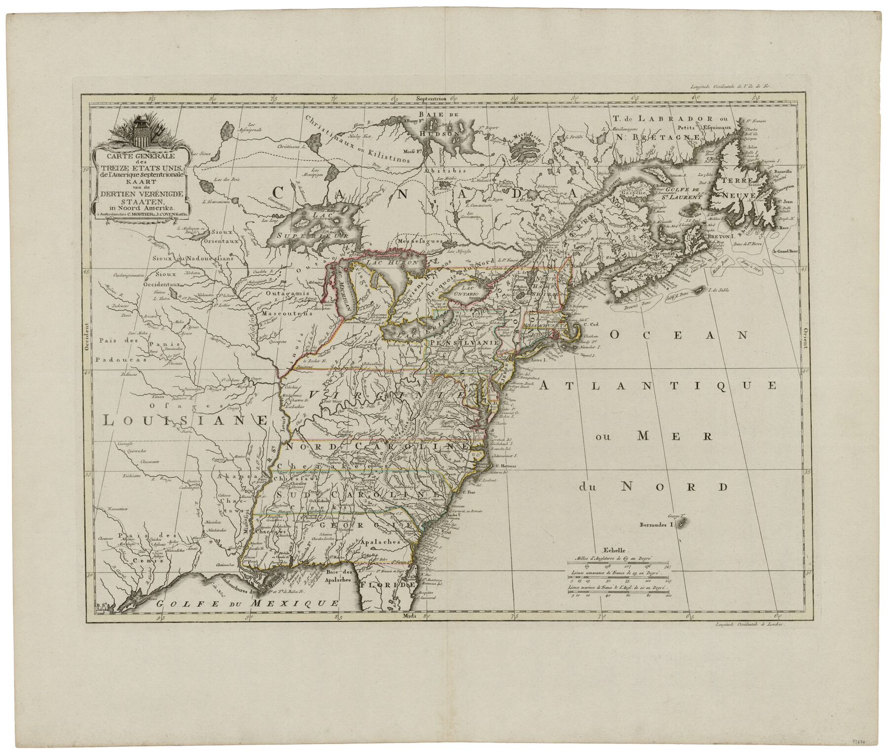
Carte Generale des Treize Etats-Unis de l'Amerique Septentrionale
Kaart van de Dertien Verénigde Staaten in Noord Amerika
-
Map/Doc
93678
-
Collection
General Map Collection
-
Object Dates
1783 (Creation Date)
2014/4/22 (File Date)
-
People and Organizations
C. Mortier, J. Covens et fils (Publisher)
Cornielle Mortier (Author)
Jean Covens (Author)
-
Subjects
North America United States
-
Height x Width
22.9 x 27.0 inches
58.2 x 68.6 cm
-
Medium
paper, etching/engraving/lithograph
-
URLs
https://medium.com/save-texas-history/mapping-texas-from-frontier-to-the-lone-star-state-western-expansion-58c399960a2c#.4ikzsevyl
Part of: General Map Collection
Map of Bexar County

Print $20.00
- Digital $50.00
Map of Bexar County
1896
Size 45.2 x 40.2 inches
Map/Doc 4885
San Patricio County Sketch File 20

Print $14.00
San Patricio County Sketch File 20
1868
Size 9.2 x 8.5 inches
Map/Doc 36069
Gaines County Rolled Sketch 27

Print $20.00
- Digital $50.00
Gaines County Rolled Sketch 27
1983
Size 35.6 x 41.8 inches
Map/Doc 9042
Flight Mission No. DIX-5P, Frame 142, Aransas County

Print $20.00
- Digital $50.00
Flight Mission No. DIX-5P, Frame 142, Aransas County
1956
Size 18.0 x 18.0 inches
Map/Doc 83803
Hardin County Sketch File 66

Print $20.00
- Digital $50.00
Hardin County Sketch File 66
1948
Size 19.5 x 35.8 inches
Map/Doc 11639
[Beaumont, Sour Lake and Western Ry. Right of Way and Alignment - Frisco]
![64115, [Beaumont, Sour Lake and Western Ry. Right of Way and Alignment - Frisco], General Map Collection](https://historictexasmaps.com/wmedia_w700/maps/64115.tif.jpg)
Print $20.00
- Digital $50.00
[Beaumont, Sour Lake and Western Ry. Right of Way and Alignment - Frisco]
1910
Size 20.1 x 45.9 inches
Map/Doc 64115
Carson County Working Sketch Graphic Index

Print $20.00
- Digital $50.00
Carson County Working Sketch Graphic Index
1932
Size 41.3 x 37.9 inches
Map/Doc 76488
Duval County Rolled Sketch 37

Print $20.00
- Digital $50.00
Duval County Rolled Sketch 37
Size 27.1 x 17.9 inches
Map/Doc 5752
Smith County Working Sketch 1

Print $20.00
- Digital $50.00
Smith County Working Sketch 1
Size 16.3 x 13.0 inches
Map/Doc 63886
Duval County Working Sketch 6

Print $20.00
- Digital $50.00
Duval County Working Sketch 6
1935
Size 26.9 x 21.8 inches
Map/Doc 68719
Fort Bend County Sketch File 21

Print $4.00
- Digital $50.00
Fort Bend County Sketch File 21
1882
Size 8.8 x 13.4 inches
Map/Doc 22954
Rio Grande Rectification Project, El Paso and Juarez Valley

Print $20.00
- Digital $50.00
Rio Grande Rectification Project, El Paso and Juarez Valley
1935
Size 10.8 x 29.6 inches
Map/Doc 60861
You may also like
Young County Working Sketch 18

Print $20.00
- Digital $50.00
Young County Working Sketch 18
1960
Size 23.9 x 29.2 inches
Map/Doc 62041
Travis County Appraisal District Plat Map 2_2011

Print $20.00
- Digital $50.00
Travis County Appraisal District Plat Map 2_2011
Size 21.4 x 26.4 inches
Map/Doc 94211
Hardeman County Aerial Photograph Index Sheet 3

Print $20.00
- Digital $50.00
Hardeman County Aerial Photograph Index Sheet 3
1950
Size 20.3 x 17.0 inches
Map/Doc 83699
Palo Pinto County Working Sketch 23

Print $40.00
- Digital $50.00
Palo Pinto County Working Sketch 23
1985
Map/Doc 71406
[Sketch for Mineral Application 13439 - Old River, Walle Merritt]
![65689, [Sketch for Mineral Application 13439 - Old River, Walle Merritt], General Map Collection](https://historictexasmaps.com/wmedia_w700/maps/65689-1.tif.jpg)
Print $20.00
- Digital $50.00
[Sketch for Mineral Application 13439 - Old River, Walle Merritt]
1925
Size 41.0 x 19.0 inches
Map/Doc 65689
Mitchell County

Print $20.00
- Digital $50.00
Mitchell County
1922
Size 42.6 x 38.3 inches
Map/Doc 2309
Map of the City of Austin

Print $20.00
Map of the City of Austin
1910
Size 24.0 x 18.0 inches
Map/Doc 90071
Map of Eastham State Farm, Houston County, Texas

Print $20.00
- Digital $50.00
Map of Eastham State Farm, Houston County, Texas
Size 35.7 x 32.5 inches
Map/Doc 62987
San Patricio County Rolled Sketch 57

Print $40.00
- Digital $50.00
San Patricio County Rolled Sketch 57
2006
Size 37.2 x 50.0 inches
Map/Doc 83554
Carte du Mexique ou de la Nouvelle Espagne

Print $20.00
Carte du Mexique ou de la Nouvelle Espagne
1750
Size 12.4 x 15.5 inches
Map/Doc 79741
Hall County Sketch File 18

Print $20.00
- Digital $50.00
Hall County Sketch File 18
Size 16.8 x 35.1 inches
Map/Doc 11609
Panola County Sketch File 17

Print $20.00
- Digital $50.00
Panola County Sketch File 17
Size 15.2 x 17.7 inches
Map/Doc 12137