Andrews County Sketch File 12
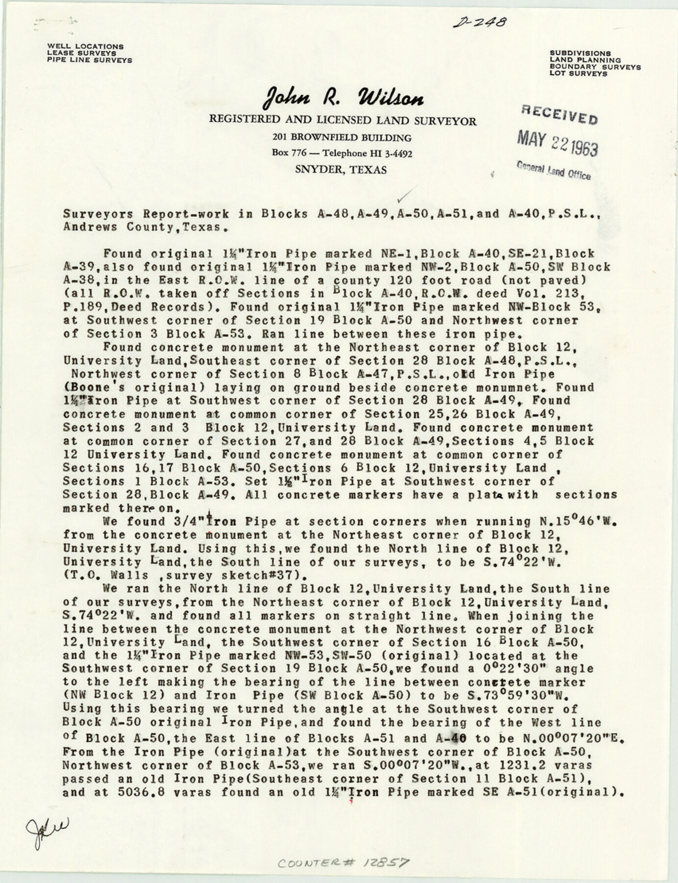
[Surveyor's report of work in Blocks A-48, A-49, A-50, A-51, and A-40 PSL]
-
Map/Doc
12857
-
Collection
General Map Collection
-
Object Dates
1963/5/11 (Creation Date)
1963/5/22 (File Date)
-
People and Organizations
John R. Wilson (Surveyor/Engineer)
-
Counties
Andrews
-
Subjects
Surveying Sketch File
-
Height x Width
11.1 x 8.5 inches
28.2 x 21.6 cm
-
Medium
paper, print
-
Comments
See Andrews County Rolled Sketch 38 (8400) for sketch.
Related maps
Andrews County Rolled Sketch 38

Print $40.00
- Digital $50.00
Andrews County Rolled Sketch 38
1963
Size 38.3 x 50.3 inches
Map/Doc 8400
Part of: General Map Collection
Stonewall County Working Sketch Graphic Index - sheet A

Print $20.00
- Digital $50.00
Stonewall County Working Sketch Graphic Index - sheet A
1933
Size 43.3 x 36.2 inches
Map/Doc 76704
[Sketch for Mineral Application 27669 - Trinity River, Frank R. Graves]
![2856, [Sketch for Mineral Application 27669 - Trinity River, Frank R. Graves], General Map Collection](https://historictexasmaps.com/wmedia_w700/maps/2856-1.tif.jpg)
Print $20.00
- Digital $50.00
[Sketch for Mineral Application 27669 - Trinity River, Frank R. Graves]
1934
Size 24.9 x 36.0 inches
Map/Doc 2856
Sherman County Sketch File 5

Print $2.00
- Digital $50.00
Sherman County Sketch File 5
1993
Size 14.6 x 9.0 inches
Map/Doc 36723
Taylor County Sketch File 1

Print $20.00
- Digital $50.00
Taylor County Sketch File 1
Size 33.3 x 40.8 inches
Map/Doc 10381
Crosby County Sketch File 1a

Print $6.00
- Digital $50.00
Crosby County Sketch File 1a
1874
Size 11.0 x 14.2 inches
Map/Doc 19987
Flight Mission No. CRC-2R, Frame 1, Chambers County

Print $20.00
- Digital $50.00
Flight Mission No. CRC-2R, Frame 1, Chambers County
1956
Size 18.7 x 22.5 inches
Map/Doc 84720
Travis County Rolled Sketch 11

Print $20.00
- Digital $50.00
Travis County Rolled Sketch 11
Size 23.3 x 37.9 inches
Map/Doc 8014
Angelina County Working Sketch 28

Print $20.00
- Digital $50.00
Angelina County Working Sketch 28
1954
Size 28.9 x 26.0 inches
Map/Doc 67110
Montague County Working Sketch 26

Print $20.00
- Digital $50.00
Montague County Working Sketch 26
1956
Size 23.5 x 23.2 inches
Map/Doc 71092
J.H. Clark's Report of 1861 - Boundary Between Texas and New Mexico

Print $78.00
J.H. Clark's Report of 1861 - Boundary Between Texas and New Mexico
1861
Map/Doc 81689
Flight Mission No. DAG-24K, Frame 139, Matagorda County

Print $20.00
- Digital $50.00
Flight Mission No. DAG-24K, Frame 139, Matagorda County
1953
Size 18.5 x 22.3 inches
Map/Doc 86557
Starr County Sketch File 24

Print $20.00
- Digital $50.00
Starr County Sketch File 24
1922
Size 15.7 x 19.5 inches
Map/Doc 12332
You may also like
Goliad County Sketch File 21

Print $10.00
- Digital $50.00
Goliad County Sketch File 21
1855
Size 12.0 x 7.9 inches
Map/Doc 24284
Andrews County Rolled Sketch 8

Print $40.00
- Digital $50.00
Andrews County Rolled Sketch 8
1928
Size 31.4 x 54.0 inches
Map/Doc 8388
Reagan County Working Sketch 35

Print $40.00
- Digital $50.00
Reagan County Working Sketch 35
1966
Size 29.7 x 51.4 inches
Map/Doc 71877
[Sketch Showing Blocks O18, P Mc, B10 and B11]
![93107, [Sketch Showing Blocks O18, P Mc, B10 and B11], Twichell Survey Records](https://historictexasmaps.com/wmedia_w700/maps/93107-1.tif.jpg)
Print $3.00
- Digital $50.00
[Sketch Showing Blocks O18, P Mc, B10 and B11]
Size 11.5 x 11.2 inches
Map/Doc 93107
The Official Map of the City of El Paso, State of Texas

Print $20.00
The Official Map of the City of El Paso, State of Texas
1889
Size 42.4 x 54.4 inches
Map/Doc 89617
Flight Mission No. CGN-3P, Frame 53, San Patricio County

Print $20.00
- Digital $50.00
Flight Mission No. CGN-3P, Frame 53, San Patricio County
1956
Size 18.6 x 22.3 inches
Map/Doc 86983
Flight Mission No. DQO-7K, Frame 80, Galveston County

Print $20.00
- Digital $50.00
Flight Mission No. DQO-7K, Frame 80, Galveston County
1952
Size 18.8 x 22.4 inches
Map/Doc 85107
Harris County State Real Property Sketch 1

Print $40.00
- Digital $50.00
Harris County State Real Property Sketch 1
1985
Size 42.7 x 41.6 inches
Map/Doc 61690
Terry County Rolled Sketch 7

Print $20.00
- Digital $50.00
Terry County Rolled Sketch 7
1903
Size 19.6 x 19.9 inches
Map/Doc 7981
[Mrs. May Vinson Survey]
![91869, [Mrs. May Vinson Survey], Twichell Survey Records](https://historictexasmaps.com/wmedia_w700/maps/91869-1.tif.jpg)
Print $20.00
- Digital $50.00
[Mrs. May Vinson Survey]
Size 25.5 x 14.8 inches
Map/Doc 91869
Atascosa County Working Sketch 13

Print $20.00
- Digital $50.00
Atascosa County Working Sketch 13
1929
Size 25.0 x 26.5 inches
Map/Doc 67209
Parker County Rolled Sketch 3

Print $20.00
- Digital $50.00
Parker County Rolled Sketch 3
1975
Size 22.7 x 18.3 inches
Map/Doc 7204