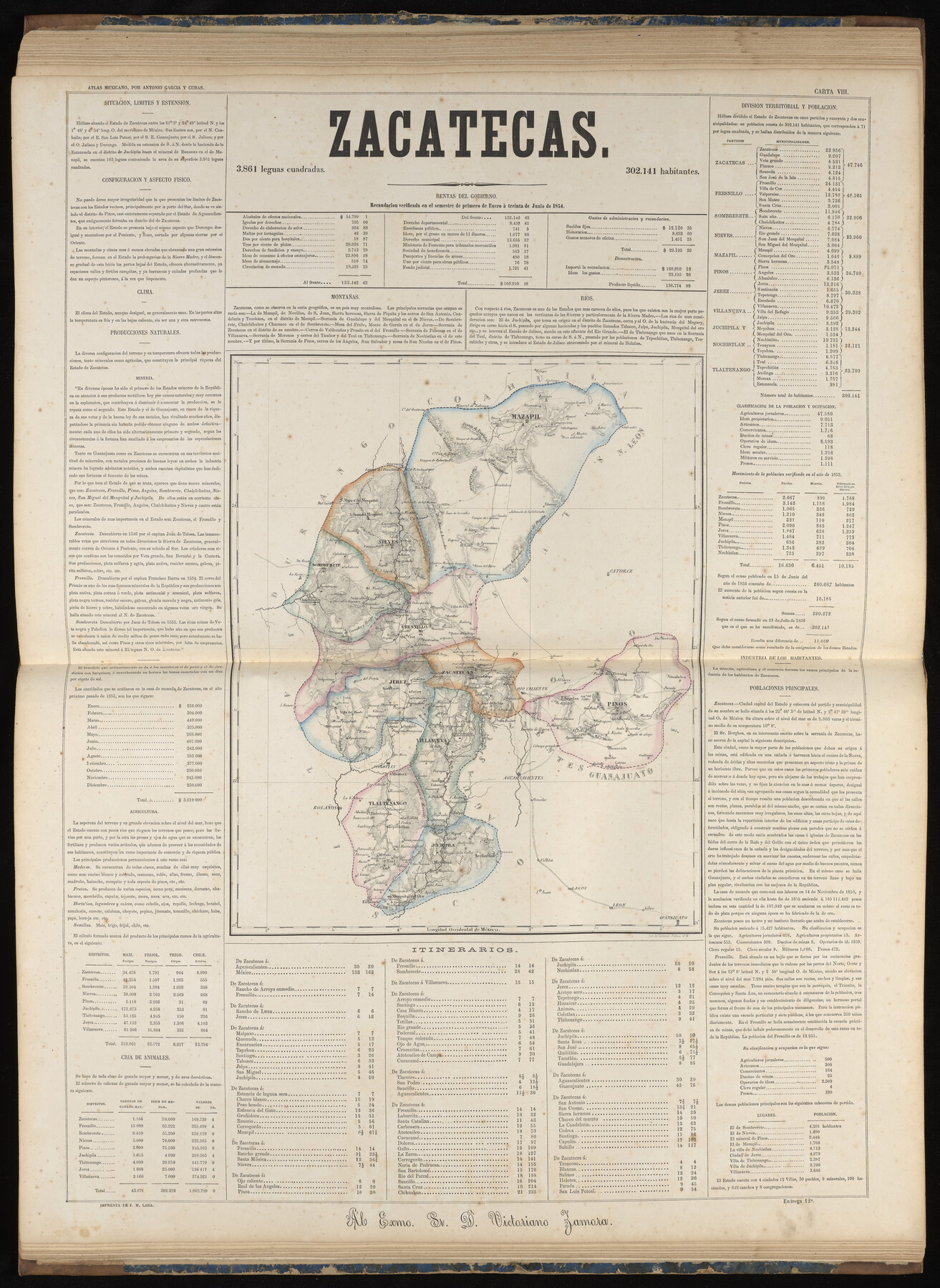
Zacatecas
-
Map/Doc
97006
-
Collection
General Map Collection
-
Object Dates
1858 (Publication Date)
-
People and Organizations
Antonio García y Cubas (Cartographer)
-
Subjects
Atlas Mexico
-
Height x Width
31.5 x 23.0 inches
80.0 x 58.4 cm
-
Medium
paper, etching/engraving/lithograph
-
Comments
Map 25 of 32 from "Atlas Geografico, Estadistico e Historico de la Republica Mexicana" (95689)
Related maps
Atlas Geográfico, Estadístico é Histórico de la República Mexicana

Atlas Geográfico, Estadístico é Histórico de la República Mexicana
Map/Doc 95689
Part of: General Map Collection
Mitchell County Working Sketch Graphic Index

Print $20.00
- Digital $50.00
Mitchell County Working Sketch Graphic Index
1971
Size 41.0 x 34.4 inches
Map/Doc 76644
General Homes Free Houston Area Map

General Homes Free Houston Area Map
Size 27.1 x 42.5 inches
Map/Doc 94393
Upshur County Working Sketch 6

Print $20.00
- Digital $50.00
Upshur County Working Sketch 6
1943
Size 28.6 x 34.3 inches
Map/Doc 69562
Angelina County Working Sketch 30

Print $20.00
- Digital $50.00
Angelina County Working Sketch 30
1955
Size 26.2 x 27.7 inches
Map/Doc 67112
Van Zandt County Working Sketch 1

Print $20.00
- Digital $50.00
Van Zandt County Working Sketch 1
1946
Size 23.7 x 30.0 inches
Map/Doc 72250
Carta Esferica que comprehende las costas del Seno Mexicano construida de orden del rey en el deposito hidrografico de marina: Por disposicion del Exmo. Señor Don Juan de Langara, Secretario de Estado y del Despacho Universal de ella. Año de 1799.

Print $20.00
- Digital $50.00
Carta Esferica que comprehende las costas del Seno Mexicano construida de orden del rey en el deposito hidrografico de marina: Por disposicion del Exmo. Señor Don Juan de Langara, Secretario de Estado y del Despacho Universal de ella. Año de 1799.
1799
Size 25.9 x 37.3 inches
Map/Doc 95367
Howard County Boundary File 4

Print $16.00
- Digital $50.00
Howard County Boundary File 4
Size 9.4 x 4.3 inches
Map/Doc 55158
Victoria County Sketch File 10

Print $4.00
- Digital $50.00
Victoria County Sketch File 10
1873
Size 10.1 x 8.4 inches
Map/Doc 39534
Flight Mission No. CGI-1N, Frame 134, Cameron County

Print $20.00
- Digital $50.00
Flight Mission No. CGI-1N, Frame 134, Cameron County
1955
Size 18.5 x 22.1 inches
Map/Doc 84490
Sabine Pass and Lake

Print $20.00
- Digital $50.00
Sabine Pass and Lake
1973
Size 47.0 x 27.8 inches
Map/Doc 69826
Van Zandt County Sketch File 43

Print $4.00
- Digital $50.00
Van Zandt County Sketch File 43
1874
Size 12.7 x 8.1 inches
Map/Doc 39497
Flight Mission No. DQN-3K, Frame 9, Calhoun County

Print $20.00
- Digital $50.00
Flight Mission No. DQN-3K, Frame 9, Calhoun County
1953
Size 18.6 x 22.2 inches
Map/Doc 84341
You may also like
Knox County Boundary File 6

Print $4.00
- Digital $50.00
Knox County Boundary File 6
Size 11.4 x 8.7 inches
Map/Doc 65049
Right of Way and Track Map, the Missouri, Kansas and Texas Ry. of Texas operated by the Missouri, Kansas and Texas Ry. of Texas, San Antonio Division

Print $40.00
- Digital $50.00
Right of Way and Track Map, the Missouri, Kansas and Texas Ry. of Texas operated by the Missouri, Kansas and Texas Ry. of Texas, San Antonio Division
1918
Size 25.6 x 58.7 inches
Map/Doc 64581
Schleicher County Working Sketch 8

Print $20.00
- Digital $50.00
Schleicher County Working Sketch 8
1923
Size 21.6 x 18.6 inches
Map/Doc 63810
Harris County Working Sketch 12

Print $20.00
- Digital $50.00
Harris County Working Sketch 12
1913
Size 17.7 x 21.3 inches
Map/Doc 65904
Right of Way and Track Map, Dayton-Goose Creek Ry. Co., Station 612+40 to Station 792+00

Print $40.00
- Digital $50.00
Right of Way and Track Map, Dayton-Goose Creek Ry. Co., Station 612+40 to Station 792+00
1917
Size 25.3 x 56.5 inches
Map/Doc 64368
West Part Houston Co.

Print $20.00
- Digital $50.00
West Part Houston Co.
1944
Size 47.2 x 41.6 inches
Map/Doc 77317
Political Essay on the Kingdom of New Spain Vol. 1, Third Edition

Political Essay on the Kingdom of New Spain Vol. 1, Third Edition
1822
Map/Doc 97386
Nacogdoches County

Print $40.00
- Digital $50.00
Nacogdoches County
1950
Size 48.1 x 44.1 inches
Map/Doc 95598
Cherokee County Sketch File 20

Print $4.00
- Digital $50.00
Cherokee County Sketch File 20
1876
Size 8.2 x 6.0 inches
Map/Doc 18163
Sabine Pass and mouth of the River Sabine in the sea

Print $20.00
- Digital $50.00
Sabine Pass and mouth of the River Sabine in the sea
1842
Size 24.0 x 19.1 inches
Map/Doc 93766
Pecos County Sketch File 85

Print $19.00
- Digital $50.00
Pecos County Sketch File 85
1948
Size 14.6 x 9.2 inches
Map/Doc 33955
[Drawings of individual counties for Pressler and Langermann's 1879 Map of Texas]
![[Drawings of individual counties for Pressler and Langermann's 1879 Map of Texas]](https://historictexasmaps.com/wmedia_w700/maps/4864.tif.jpg)
Print $20.00
- Digital $50.00
[Drawings of individual counties for Pressler and Langermann's 1879 Map of Texas]
1878
Size 38.3 x 26.8 inches
Map/Doc 4864