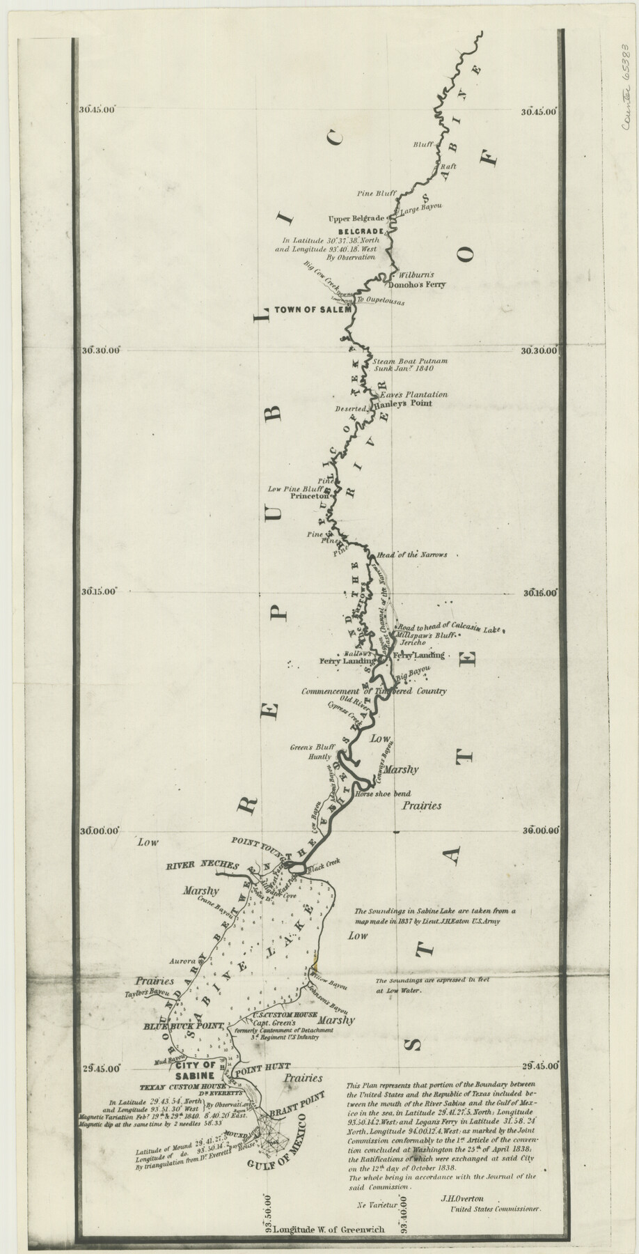
Map of the River Sabine from its mouth on the Gulf of Mexico in the sea to Logan's Ferry in latitude 31° 58' 24" north
K-7-65
-
Map/Doc
65383
-
Collection
General Map Collection
-
Object Dates
1842 (Creation Date)
-
People and Organizations
Joint Boundary Commission (Author)
George G. Meade (Surveyor/Engineer)
A.B. Gray (Surveyor/Engineer)
T.J. Lee (Draftsman)
P.J. Pillans (Surveyor/Engineer)
D.C. Wilber (Surveyor/Engineer)
T.J. Lee (Surveyor/Engineer)
J.D. Graham (Surveyor/Engineer)
-
Counties
Orange Newton Nacogdoches Shelby
-
Subjects
River Surveys Texas Boundaries
-
Height x Width
18.3 x 9.3 inches
46.5 x 23.6 cm
-
Comments
Shows the boundary between the United States and the Republic of Texas between said points as marked and laid down by Survey in 1840 under the direction of the Commissioners appointed for that purpose under the 1st Article of the Convention signed at Wash
Part of: General Map Collection
Galveston County Sketch File 43

Print $40.00
- Digital $50.00
Galveston County Sketch File 43
1915
Size 19.4 x 15.1 inches
Map/Doc 11539
Flight Mission No. DJV-3P, Frame 14, Ellis County

Print $20.00
- Digital $50.00
Flight Mission No. DJV-3P, Frame 14, Ellis County
1956
Size 18.8 x 22.4 inches
Map/Doc 84976
Hopkins County Sketch File 16

Print $4.00
- Digital $50.00
Hopkins County Sketch File 16
1870
Size 8.1 x 10.1 inches
Map/Doc 26713
Coleman County Sketch File 20

Print $4.00
- Digital $50.00
Coleman County Sketch File 20
1871
Size 12.9 x 8.0 inches
Map/Doc 18694
Texas 1849: A Lone Star Rising

Print $20.00
- Digital $50.00
Texas 1849: A Lone Star Rising
2000
Size 40.6 x 40.7 inches
Map/Doc 78270
Loving County Sketch File 9

Print $36.00
- Digital $50.00
Loving County Sketch File 9
2015
Size 14.0 x 8.5 inches
Map/Doc 93794
Flight Mission No. DAH-17M, Frame 23, Orange County

Print $20.00
- Digital $50.00
Flight Mission No. DAH-17M, Frame 23, Orange County
1953
Size 18.7 x 22.5 inches
Map/Doc 86886
Kerr County Sketch File 6

Print $20.00
- Digital $50.00
Kerr County Sketch File 6
1879
Size 16.4 x 22.4 inches
Map/Doc 11917
Real County Working Sketch 20

Print $20.00
- Digital $50.00
Real County Working Sketch 20
1944
Size 19.0 x 24.9 inches
Map/Doc 71912
2017 Official Travel Map, Texas

2017 Official Travel Map, Texas
2017
Size 33.6 x 36.4 inches
Map/Doc 94415
Flight Mission No. DCL-4C, Frame 6, Kenedy County

Print $20.00
- Digital $50.00
Flight Mission No. DCL-4C, Frame 6, Kenedy County
1943
Size 18.6 x 22.2 inches
Map/Doc 85807
Terry County Sketch File 4

Print $20.00
- Digital $50.00
Terry County Sketch File 4
1913
Size 14.4 x 8.7 inches
Map/Doc 38016
You may also like
Schleicher County Rolled Sketch 15

Print $20.00
- Digital $50.00
Schleicher County Rolled Sketch 15
Size 28.8 x 41.0 inches
Map/Doc 7757
Montgomery County Sketch File 6

Print $4.00
- Digital $50.00
Montgomery County Sketch File 6
Size 4.6 x 5.7 inches
Map/Doc 31781
Harris County Rolled Sketch 80B

Print $20.00
- Digital $50.00
Harris County Rolled Sketch 80B
Size 32.0 x 44.2 inches
Map/Doc 9137
Road Guide of Central Texas, Colorado River, Highland Lakes and Hill Country

Print $20.00
- Digital $50.00
Road Guide of Central Texas, Colorado River, Highland Lakes and Hill Country
1947
Size 18.0 x 21.7 inches
Map/Doc 60293
Brewster County Rolled Sketch 19B

Print $40.00
- Digital $50.00
Brewster County Rolled Sketch 19B
1881
Size 48.5 x 39.4 inches
Map/Doc 8472
Coke County Boundary File 3

Print $18.00
- Digital $50.00
Coke County Boundary File 3
Size 8.6 x 4.0 inches
Map/Doc 51584
Matagorda Light to Aransas Pass

Print $20.00
- Digital $50.00
Matagorda Light to Aransas Pass
1924
Size 35.9 x 44.6 inches
Map/Doc 73391
Dimmit County Rolled Sketch CHM

Print $20.00
- Digital $50.00
Dimmit County Rolled Sketch CHM
1935
Size 38.1 x 41.2 inches
Map/Doc 10716
Medina County Rolled Sketch 22

Print $20.00
- Digital $50.00
Medina County Rolled Sketch 22
2007
Size 24.5 x 18.4 inches
Map/Doc 88849
Map of the Republic of Texas showing its division into counties and latest improvements too

Print $20.00
- Digital $50.00
Map of the Republic of Texas showing its division into counties and latest improvements too
1837
Size 12.3 x 9.6 inches
Map/Doc 76874
Erath County Working Sketch 50a

Print $20.00
- Digital $50.00
Erath County Working Sketch 50a
Size 43.2 x 37.0 inches
Map/Doc 69131
[Lgs. 180-183, 196-198, 105-112, 678-680, 699-701, 141-143]
![90155, [Lgs. 180-183, 196-198, 105-112, 678-680, 699-701, 141-143], Twichell Survey Records](https://historictexasmaps.com/wmedia_w700/maps/90155-1.tif.jpg)
Print $2.00
- Digital $50.00
[Lgs. 180-183, 196-198, 105-112, 678-680, 699-701, 141-143]
1913
Size 9.9 x 6.0 inches
Map/Doc 90155