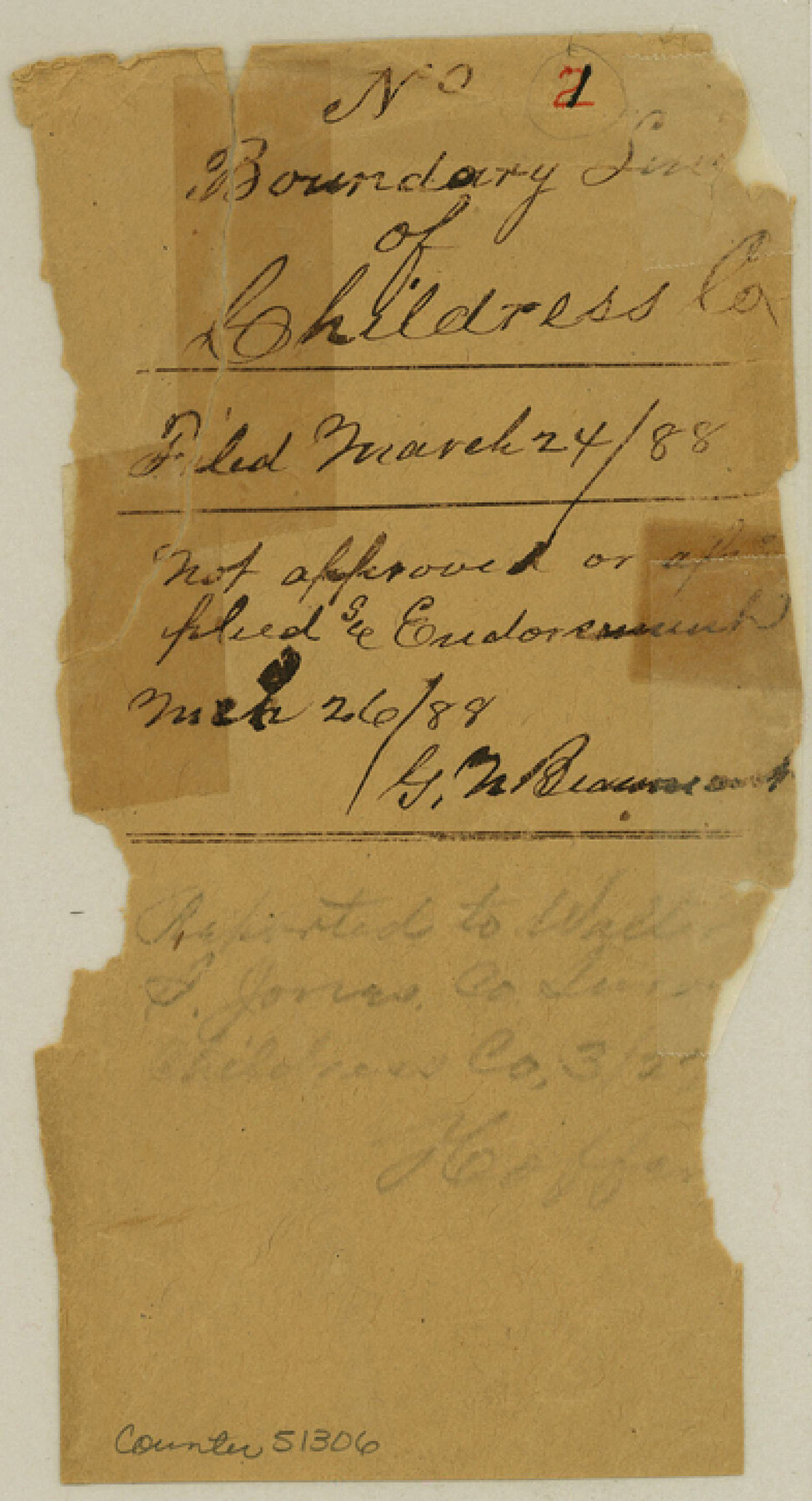
Childress County Boundary File 2
-
Map/Doc
51306
-
Collection
General Map Collection
-
Counties
Childress
-
Subjects
County Boundaries
-
Height x Width
7.3 x 3.9 inches
18.5 x 9.9 cm
Part of: General Map Collection
Foard County Boundary File 2a

Print $40.00
- Digital $50.00
Foard County Boundary File 2a
Size 33.2 x 14.7 inches
Map/Doc 53514
Dallas County

Print $20.00
- Digital $50.00
Dallas County
1942
Size 44.5 x 36.9 inches
Map/Doc 95475

Presidio County Working Sketch 144

Print $20.00
- Digital $50.00
Presidio County Working Sketch 144
1990
Size 20.4 x 26.6 inches
Map/Doc 71822
Dimmit County Sketch File 55

Print $20.00
- Digital $50.00
Dimmit County Sketch File 55
1926
Size 23.1 x 15.7 inches
Map/Doc 11359
Cameron County Rolled Sketch 21

Print $20.00
- Digital $50.00
Cameron County Rolled Sketch 21
1952
Size 27.3 x 40.2 inches
Map/Doc 8573
El Paso County Rolled Sketch 65

Print $20.00
- Digital $50.00
El Paso County Rolled Sketch 65
2012
Size 24.5 x 36.8 inches
Map/Doc 93327
Starr County Working Sketch 8

Print $20.00
- Digital $50.00
Starr County Working Sketch 8
1939
Size 21.9 x 28.8 inches
Map/Doc 63924
Nueces County Rolled Sketch 63A

Print $20.00
- Digital $50.00
Nueces County Rolled Sketch 63A
1979
Size 25.0 x 36.7 inches
Map/Doc 6910
Presidio County Sketch File 81

Print $20.00
- Digital $50.00
Presidio County Sketch File 81
1949
Size 47.2 x 21.6 inches
Map/Doc 10579
Flight Mission No. BRA-7M, Frame 190, Jefferson County

Print $20.00
- Digital $50.00
Flight Mission No. BRA-7M, Frame 190, Jefferson County
1953
Size 18.7 x 22.3 inches
Map/Doc 85558
North Sulphur River, Ben Franklin Sheet

Print $40.00
- Digital $50.00
North Sulphur River, Ben Franklin Sheet
1928
Size 24.6 x 57.4 inches
Map/Doc 65172
You may also like
Presidio County Rolled Sketch 24

Print $40.00
- Digital $50.00
Presidio County Rolled Sketch 24
1886
Size 158.3 x 23.4 inches
Map/Doc 9765
Terrell County Sketch File 24a

Print $20.00
- Digital $50.00
Terrell County Sketch File 24a
1932
Size 30.4 x 42.2 inches
Map/Doc 10388
Val Verde County Rolled Sketch 40

Print $40.00
- Digital $50.00
Val Verde County Rolled Sketch 40
Size 39.0 x 123.5 inches
Map/Doc 10073
Marion County Working Sketch 38

Print $20.00
- Digital $50.00
Marion County Working Sketch 38
1991
Size 35.5 x 39.9 inches
Map/Doc 70814
Harris County Sketch File 64

Print $40.00
- Digital $50.00
Harris County Sketch File 64
Size 16.3 x 14.1 inches
Map/Doc 25503
Hardeman County Sketch File 4

Print $6.00
- Digital $50.00
Hardeman County Sketch File 4
Size 9.3 x 8.2 inches
Map/Doc 24991
Hill County Sketch File 1

Print $4.00
- Digital $50.00
Hill County Sketch File 1
1857
Size 9.0 x 7.9 inches
Map/Doc 26459
La Salle County Working Sketch 25

Print $20.00
- Digital $50.00
La Salle County Working Sketch 25
1947
Size 32.8 x 41.0 inches
Map/Doc 70326
Freestone County Rolled Sketch 12A

Print $40.00
- Digital $50.00
Freestone County Rolled Sketch 12A
1987
Size 35.2 x 48.6 inches
Map/Doc 8897
McMullen County Working Sketch 11

Print $20.00
- Digital $50.00
McMullen County Working Sketch 11
1938
Size 26.8 x 31.6 inches
Map/Doc 70712
General Highway Map, Bailey County, Texas

Print $20.00
General Highway Map, Bailey County, Texas
1940
Size 25.1 x 18.3 inches
Map/Doc 79010
[F. W. & D. C. Ry. Co. Alignment and Right of Way Map, Clay County]
![64747, [F. W. & D. C. Ry. Co. Alignment and Right of Way Map, Clay County], General Map Collection](https://historictexasmaps.com/wmedia_w700/maps/64747-GC.tif.jpg)
Print $20.00
- Digital $50.00
[F. W. & D. C. Ry. Co. Alignment and Right of Way Map, Clay County]
1927
Size 18.7 x 11.9 inches
Map/Doc 64747