Alamo Defenders Heritage Map of Texas

Print $20.00
Alamo Defenders Heritage Map of Texas
2025
Size: 36.0 x 24.0 inches
97433
Disputed Territory Between Mexico and the United States

Disputed Territory Between Mexico and the United States
2024
Size: 10.7 x 7.9 inches
97251
Military Reconstruction Districts

Military Reconstruction Districts
2024
Size: 8.5 x 11.0 inches
97345
Disputed Territory Between Mexico and the United States

Disputed Territory Between Mexico and the United States
2023
Size: 11.0 x 8.5 inches
97129
Northern Mexico Campaign of the U.S. - Mexico War

Northern Mexico Campaign of the U.S. - Mexico War
2023
Size: 8.5 x 11.0 inches
97152
American Civil War Political Loyalties

American Civil War Political Loyalties
2022
Size: 8.5 x 11.0 inches
97091
Texas and the Great War

Print $20.00
- Digital $50.00
Texas and the Great War
2017
Size: 24.3 x 18.3 inches
94412
"The Spirit of the Alamo Lives On"
.tif.jpg)
Price $20.00
"The Spirit of the Alamo Lives On"
2009
Size: 24.0 x 36.0 inches
95290
Texas Land Commissioner Jerry Patterson's Great Military Map of Texas showing Significant Conflicts and Events between 1685 and 1916

Print $20.00
- Digital $50.00
Texas Land Commissioner Jerry Patterson's Great Military Map of Texas showing Significant Conflicts and Events between 1685 and 1916
2006
Size: 36.7 x 24.8 inches
83432
The Military History of Texas Map!

The Military History of Texas Map!
1996
Size: 24.2 x 35.0 inches
96828
The Military History of Texas Map!

The Military History of Texas Map!
1996
Size: 24.2 x 35.1 inches
96827
Current Miscellaneous File 26

Print $4.00
- Digital $50.00
Current Miscellaneous File 26
1952
Size: 10.7 x 8.3 inches
73907
Calhoun County Rolled Sketch 11

Print $20.00
- Digital $50.00
Calhoun County Rolled Sketch 11
1942
Size: 10.6 x 40.7 inches
5367
Proposed bombing and machine gun restricted areas along Gulf of Mexico from San Luis Pass to Aransas Pass

Print $20.00
- Digital $50.00
Proposed bombing and machine gun restricted areas along Gulf of Mexico from San Luis Pass to Aransas Pass
1941
Size: 11.1 x 24.1 inches
3024
Trails made and routes used by the Fourth U.S. Cavalry under command of General R.S. Mackenzie in its operations against hostile indians in Texas, Indian-Territory (now Oklahoma), New Mexico and Old Mexico during the period of 1871-2-3-4 and 5

Print $20.00
- Digital $50.00
Trails made and routes used by the Fourth U.S. Cavalry under command of General R.S. Mackenzie in its operations against hostile indians in Texas, Indian-Territory (now Oklahoma), New Mexico and Old Mexico during the period of 1871-2-3-4 and 5
1927
Size: 37.0 x 34.2 inches
62973
Engineer map showing engineer information at 23 O'Clock 23 Oct. 1918 drawn under direction of Col. W.A. Mitchell

Print $20.00
Engineer map showing engineer information at 23 O'Clock 23 Oct. 1918 drawn under direction of Col. W.A. Mitchell
1918
Size: 19.6 x 12.5 inches
94127
Engineer map showing engineer information at 23 O'Clock 23 Oct. 1918 drawn under direction of Col. W.A. Mitchell - Verso

Print $20.00
Engineer map showing engineer information at 23 O'Clock 23 Oct. 1918 drawn under direction of Col. W.A. Mitchell - Verso
1918
Size: 19.7 x 12.6 inches
94128
[Movements & Objectives of the 143rd & 144th Infantry and many other divisions and regiments, 1918] - Verso

Print $40.00
[Movements & Objectives of the 143rd & 144th Infantry and many other divisions and regiments, 1918] - Verso
1918
Size: 37.2 x 63.9 inches
94139
[Movements & Objectives of the 143rd & 144th Infantry and many other divisions and regiments, 1918]
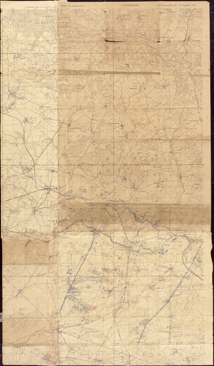
Print $40.00
[Movements & Objectives of the 143rd & 144th Infantry and many other divisions and regiments, 1918]
1918
Size: 64.2 x 37.5 inches
94138
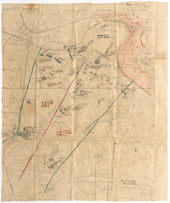
[Movements & Objectives of the 143rd & 144th Infantry on October 12-13, 1918]
Print $20.00
[Movements & Objectives of the 143rd & 144th Infantry on October 12-13, 1918]
1918
Size: 42.4 x 30.0 inches
94135
[Movements & Objectives of the 143rd & 144th Infantry on October 12-13, 1918] - Verso
Print $20.00
[Movements & Objectives of the 143rd & 144th Infantry on October 12-13, 1918] - Verso
1918
Size: 42.4 x 30.0 inches
94136
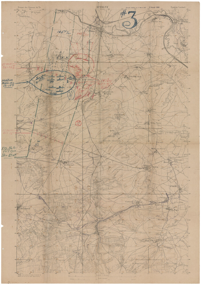
[1/4 of a WWI French map of Attigny used by the 142nd Infantry for planning purposes for the Battle of Forest Ferme (farm)]
Print $20.00
[1/4 of a WWI French map of Attigny used by the 142nd Infantry for planning purposes for the Battle of Forest Ferme (farm)]
1918
Size: 21.1 x 17.7 inches
96642
[Movements & Objectives of the 143rd & 144th Infantry on October 13, 1918, Appendix L]
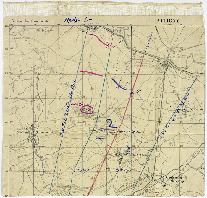
Print $20.00
[Movements & Objectives of the 143rd & 144th Infantry on October 13, 1918, Appendix L]
1918
Size: 16.1 x 16.8 inches
94124
Alamo Defenders Heritage Map of Texas
Print $20.00
Alamo Defenders Heritage Map of Texas
2025
The Alamo is a sacred place where history, sacrifice, and pride come together to tell the powerful...
-
Size
36.0 x 24.0 inches
-
Map/Doc
97433
-
Creation Date
2025
Events of the Texas Revolution

Events of the Texas Revolution
2025
-
Size
8.5 x 11.0 inches
-
Map/Doc
97489
-
Creation Date
2025
Disputed Territory Between Mexico and the United States
Disputed Territory Between Mexico and the United States
2024
-
Size
10.7 x 7.9 inches
-
Map/Doc
97251
-
Creation Date
2024
Military Reconstruction Districts
Military Reconstruction Districts
2024
-
Size
8.5 x 11.0 inches
-
Map/Doc
97345
-
Creation Date
2024
Disputed Territory Between Mexico and the United States
Disputed Territory Between Mexico and the United States
2023
-
Size
11.0 x 8.5 inches
-
Map/Doc
97129
-
Creation Date
2023
Northern Mexico Campaign of the U.S. - Mexico War
Northern Mexico Campaign of the U.S. - Mexico War
2023
-
Size
8.5 x 11.0 inches
-
Map/Doc
97152
-
Creation Date
2023
Events of the Texas Revolution

Events of the Texas Revolution
2023
-
Size
8.5 x 11.0 inches
-
Map/Doc
97188
-
Creation Date
2023
Events of the Texas Revolution

Events of the Texas Revolution
2023
-
Size
11.0 x 8.5 inches
-
Map/Doc
97189
-
Creation Date
2023
Events of the Texas Revolution

Events of the Texas Revolution
2023
-
Size
11.0 x 17.0 inches
-
Map/Doc
97194
-
Creation Date
2023
Battle of Cerro Gordo

Battle of Cerro Gordo
2022
-
Size
8.5 x 11.0 inches
-
Map/Doc
97090
-
Creation Date
2022
American Civil War Political Loyalties
American Civil War Political Loyalties
2022
-
Size
8.5 x 11.0 inches
-
Map/Doc
97091
-
Creation Date
2022
Texas and the Great War
Print $20.00
- Digital $50.00
Texas and the Great War
2017
Promotional map and poster for the 2017 Save Texas History Symposium.
-
Size
24.3 x 18.3 inches
-
Map/Doc
94412
-
Creation Date
2017
"The Spirit of the Alamo Lives On"
Print $20.00
"The Spirit of the Alamo Lives On"
2009
Created by artist George L. Skypeck, "The Spirit of the Alamo Lives On" commemorates the storied...
-
Size
24.0 x 36.0 inches
-
Map/Doc
95290
-
Creation Date
2009
Texas Land Commissioner Jerry Patterson's Great Military Map of Texas showing Significant Conflicts and Events between 1685 and 1916
Print $20.00
- Digital $50.00
Texas Land Commissioner Jerry Patterson's Great Military Map of Texas showing Significant Conflicts and Events between 1685 and 1916
2006
-
Size
36.7 x 24.8 inches
-
Map/Doc
83432
-
Creation Date
2006
The Military History of Texas Map!
The Military History of Texas Map!
1996
-
Size
24.2 x 35.0 inches
-
Map/Doc
96828
-
Creation Date
1996
The Military History of Texas Map!
The Military History of Texas Map!
1996
-
Size
24.2 x 35.1 inches
-
Map/Doc
96827
-
Creation Date
1996
Battlefields of the Civil War

Battlefields of the Civil War
1961
-
Size
25.8 x 19.7 inches
-
Map/Doc
92373
-
Creation Date
1961
Battlefields of the Civil War

Battlefields of the Civil War
1961
-
Size
25.8 x 19.7 inches
-
Map/Doc
92374
-
Creation Date
1961
Current Miscellaneous File 26
Print $4.00
- Digital $50.00
Current Miscellaneous File 26
1952
-
Size
10.7 x 8.3 inches
-
Map/Doc
73907
-
Creation Date
1952
Calhoun County Rolled Sketch 11
Print $20.00
- Digital $50.00
Calhoun County Rolled Sketch 11
1942
-
Size
10.6 x 40.7 inches
-
Map/Doc
5367
-
Creation Date
1942
Proposed bombing and machine gun restricted areas along Gulf of Mexico from San Luis Pass to Aransas Pass
Print $20.00
- Digital $50.00
Proposed bombing and machine gun restricted areas along Gulf of Mexico from San Luis Pass to Aransas Pass
1941
-
Size
11.1 x 24.1 inches
-
Map/Doc
3024
-
Creation Date
1941
Trails made and routes used by the Fourth U.S. Cavalry under command of General R.S. Mackenzie in its operations against hostile indians in Texas, Indian-Territory (now Oklahoma), New Mexico and Old Mexico during the period of 1871-2-3-4 and 5
Print $20.00
- Digital $50.00
Trails made and routes used by the Fourth U.S. Cavalry under command of General R.S. Mackenzie in its operations against hostile indians in Texas, Indian-Territory (now Oklahoma), New Mexico and Old Mexico during the period of 1871-2-3-4 and 5
1927
-
Size
37.0 x 34.2 inches
-
Map/Doc
62973
-
Creation Date
1927
Engineer map showing engineer information at 23 O'Clock 23 Oct. 1918 drawn under direction of Col. W.A. Mitchell
Print $20.00
Engineer map showing engineer information at 23 O'Clock 23 Oct. 1918 drawn under direction of Col. W.A. Mitchell
1918
-
Size
19.6 x 12.5 inches
-
Map/Doc
94127
-
Creation Date
1918
Engineer map showing engineer information at 23 O'Clock 23 Oct. 1918 drawn under direction of Col. W.A. Mitchell - Verso
Print $20.00
Engineer map showing engineer information at 23 O'Clock 23 Oct. 1918 drawn under direction of Col. W.A. Mitchell - Verso
1918
-
Size
19.7 x 12.6 inches
-
Map/Doc
94128
-
Creation Date
1918
[Movements & Objectives of the 143rd & 144th Infantry and many other divisions and regiments, 1918] - Verso
Print $40.00
[Movements & Objectives of the 143rd & 144th Infantry and many other divisions and regiments, 1918] - Verso
1918
-
Size
37.2 x 63.9 inches
-
Map/Doc
94139
-
Creation Date
1918
[Movements & Objectives of the 143rd & 144th Infantry and many other divisions and regiments, 1918]
Print $40.00
[Movements & Objectives of the 143rd & 144th Infantry and many other divisions and regiments, 1918]
1918
-
Size
64.2 x 37.5 inches
-
Map/Doc
94138
-
Creation Date
1918
[Movements & Objectives of the 143rd & 144th Infantry on October 12-13, 1918]
Print $20.00
[Movements & Objectives of the 143rd & 144th Infantry on October 12-13, 1918]
1918
-
Size
42.4 x 30.0 inches
-
Map/Doc
94135
-
Creation Date
1918
[Movements & Objectives of the 143rd & 144th Infantry on October 12-13, 1918] - Verso
Print $20.00
[Movements & Objectives of the 143rd & 144th Infantry on October 12-13, 1918] - Verso
1918
-
Size
42.4 x 30.0 inches
-
Map/Doc
94136
-
Creation Date
1918
[1/4 of a WWI French map of Attigny used by the 142nd Infantry for planning purposes for the Battle of Forest Ferme (farm)]
Print $20.00
[1/4 of a WWI French map of Attigny used by the 142nd Infantry for planning purposes for the Battle of Forest Ferme (farm)]
1918
-
Size
21.1 x 17.7 inches
-
Map/Doc
96642
-
Creation Date
1918
[Movements & Objectives of the 143rd & 144th Infantry on October 13, 1918, Appendix L]
Print $20.00
[Movements & Objectives of the 143rd & 144th Infantry on October 13, 1918, Appendix L]
1918
-
Size
16.1 x 16.8 inches
-
Map/Doc
94124
-
Creation Date
1918