"The Spirit of the Alamo Lives On"
.tif.jpg)
Price $20.00
"The Spirit of the Alamo Lives On"
2009
Size: 24.0 x 36.0 inches
95290
A Correct Map of the Seat of War in Mexico

Print $20.00
A Correct Map of the Seat of War in Mexico
1847
Size: 28.3 x 21.1 inches
79725
A Correct Map of the Seat of War in Mexico Being a Copy of Genl Arista's Map, taken at Resaca de la Palma, with additions and Corrections

Print $20.00
- Digital $50.00
A Correct Map of the Seat of War in Mexico Being a Copy of Genl Arista's Map, taken at Resaca de la Palma, with additions and Corrections
1847
Size: 30.7 x 22.5 inches
93962
A General Map of the Middle British Colonies, in America. containing Virginia, Maryland, the Delaware Counties, Pennsylvania and New Jersey. With the addition of New York and of the Greatest Part of New England

Print $20.00
- Digital $50.00
A General Map of the Middle British Colonies, in America. containing Virginia, Maryland, the Delaware Counties, Pennsylvania and New Jersey. With the addition of New York and of the Greatest Part of New England
1776
Size: 21.6 x 27.2 inches
97402
A General Map of the Northern British Colonies in America which comprehends the Province of Quebec, the Government of Newfoundland, Nova-Scotia, New England and New York

Print $20.00
- Digital $50.00
A General Map of the Northern British Colonies in America which comprehends the Province of Quebec, the Government of Newfoundland, Nova-Scotia, New England and New York
1776
Size: 21.3 x 27.3 inches
97401
A General Map of the Southern British Colonies, in America. comprehending North and South Carolina, Georgia, East and West Florida, with the Neighbouring Indian Countries

Print $20.00
- Digital $50.00
A General Map of the Southern British Colonies, in America. comprehending North and South Carolina, Georgia, East and West Florida, with the Neighbouring Indian Countries
1776
Size: 21.3 x 26.4 inches
97403
Alamo Defenders Heritage Map of Texas

Print $20.00
Alamo Defenders Heritage Map of Texas
2025
Size: 36.0 x 24.0 inches
97433
American Civil War Political Loyalties

American Civil War Political Loyalties
2022
Size: 8.5 x 11.0 inches
97091
Atlas to Accompany the Official Records of the Union and Confederate Armies, 1861-1865

Print $20.00
- Digital $50.00
Atlas to Accompany the Official Records of the Union and Confederate Armies, 1861-1865
Size: 18.6 x 29.8 inches
95412
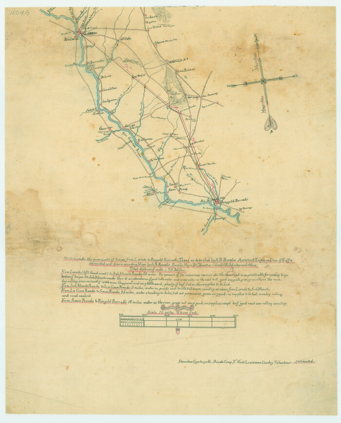
Best Route for Movements of Troops from Laredo to Ringold [sic] Barracks, Texas
Print $20.00
Best Route for Movements of Troops from Laredo to Ringold [sic] Barracks, Texas
1865
Size: 18.9 x 15.3 inches
79299
Birds-eye view of the camp of the army of occupation commanded by Genl. Taylor near Corpus Christi, Texas (from the North)

Print $20.00
- Digital $50.00
Birds-eye view of the camp of the army of occupation commanded by Genl. Taylor near Corpus Christi, Texas (from the North)
1847
Size: 15.8 x 20.5 inches
95951
Calhoun County Rolled Sketch 11

Print $20.00
- Digital $50.00
Calhoun County Rolled Sketch 11
1942
Size: 10.6 x 40.7 inches
5367
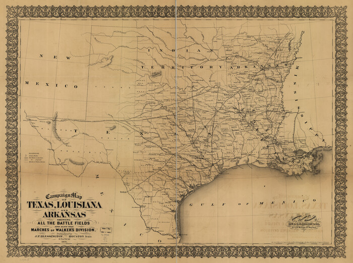
Campaign map of Texas, Louisiana and Arkansas, showing all the battle fields and also the marches of Walker's Division. [1861-65]
Print $20.00
Campaign map of Texas, Louisiana and Arkansas, showing all the battle fields and also the marches of Walker's Division. [1861-65]
1871
Size: 27.6 x 37.0 inches
93567
Coast of Texas and its defences

Print $20.00
- Digital $50.00
Coast of Texas and its defences
1864
Size: 27.3 x 18.1 inches
72683
Coast of Texas and its defences

Print $20.00
- Digital $50.00
Coast of Texas and its defences
Size: 27.8 x 18.2 inches
72684
Coast of Texas and its defences

Print $20.00
- Digital $50.00
Coast of Texas and its defences
Size: 27.6 x 18.2 inches
72685
Colton's United States shewing the military stations, forts, &c

Print $20.00
Colton's United States shewing the military stations, forts, &c
1861
Size: 14.6 x 17.3 inches
93565
Copy of a portion of Arista's map

Print $20.00
- Digital $50.00
Copy of a portion of Arista's map
1847
Size: 27.5 x 18.3 inches
73057
Copy of a portion of Arista's map

Print $20.00
- Digital $50.00
Copy of a portion of Arista's map
1847
Size: 27.5 x 18.3 inches
73058
Croquis del terro, camino, bosques, barrancas, cerro y beredas de Cerro-gordo con las posiciones de las topas Mejicanas y Americanas con sus respectivos Generales Cuerpos y Baterias el dis 18 de Abril de 1847

Print $20.00
Croquis del terro, camino, bosques, barrancas, cerro y beredas de Cerro-gordo con las posiciones de las topas Mejicanas y Americanas con sus respectivos Generales Cuerpos y Baterias el dis 18 de Abril de 1847
1847
Size: 20.1 x 26.0 inches
97343
Current Miscellaneous File 13

Print $20.00
- Digital $50.00
Current Miscellaneous File 13
Size: 16.2 x 21.6 inches
73820
Current Miscellaneous File 26

Print $4.00
- Digital $50.00
Current Miscellaneous File 26
1952
Size: 10.7 x 8.3 inches
73907
Description of Best Route from Austin to San Antonio, Texas

Print $20.00
Description of Best Route from Austin to San Antonio, Texas
1865
Size: 12.9 x 13.1 inches
79296
Description of Best Route from San Antonio to Laredo, Texas

Print $20.00
Description of Best Route from San Antonio to Laredo, Texas
1865
Size: 28.6 x 13.7 inches
79302
Disputed Territory Between Mexico and the United States

Disputed Territory Between Mexico and the United States
2023
Size: 11.0 x 8.5 inches
97129
Disputed Territory Between Mexico and the United States

Disputed Territory Between Mexico and the United States
2024
Size: 10.7 x 7.9 inches
97251
Eastern and Central Texas, Prepared by Order of Maj. Gen. N.P. Banks. Major D.C. Houston, Chief of Engineers

Print $20.00
Eastern and Central Texas, Prepared by Order of Maj. Gen. N.P. Banks. Major D.C. Houston, Chief of Engineers
1864
Size: 32.6 x 23.7 inches
88596
"The Spirit of the Alamo Lives On"
Print $20.00
"The Spirit of the Alamo Lives On"
2009
Created by artist George L. Skypeck, "The Spirit of the Alamo Lives On" commemorates the storied...
-
Size
24.0 x 36.0 inches
-
Map/Doc
95290
-
Creation Date
2009
A Correct Map of the Seat of War in Mexico
Print $20.00
A Correct Map of the Seat of War in Mexico
1847
-
Size
28.3 x 21.1 inches
-
Map/Doc
79725
-
Creation Date
1847
A Correct Map of the Seat of War in Mexico Being a Copy of Genl Arista's Map, taken at Resaca de la Palma, with additions and Corrections
Print $20.00
- Digital $50.00
A Correct Map of the Seat of War in Mexico Being a Copy of Genl Arista's Map, taken at Resaca de la Palma, with additions and Corrections
1847
-
Size
30.7 x 22.5 inches
-
Map/Doc
93962
-
Creation Date
1847
A General Map of the Middle British Colonies, in America. containing Virginia, Maryland, the Delaware Counties, Pennsylvania and New Jersey. With the addition of New York and of the Greatest Part of New England
Print $20.00
- Digital $50.00
A General Map of the Middle British Colonies, in America. containing Virginia, Maryland, the Delaware Counties, Pennsylvania and New Jersey. With the addition of New York and of the Greatest Part of New England
1776
-
Size
21.6 x 27.2 inches
-
Map/Doc
97402
-
Creation Date
1776
A General Map of the Northern British Colonies in America which comprehends the Province of Quebec, the Government of Newfoundland, Nova-Scotia, New England and New York
Print $20.00
- Digital $50.00
A General Map of the Northern British Colonies in America which comprehends the Province of Quebec, the Government of Newfoundland, Nova-Scotia, New England and New York
1776
-
Size
21.3 x 27.3 inches
-
Map/Doc
97401
-
Creation Date
1776
A General Map of the Southern British Colonies, in America. comprehending North and South Carolina, Georgia, East and West Florida, with the Neighbouring Indian Countries
Print $20.00
- Digital $50.00
A General Map of the Southern British Colonies, in America. comprehending North and South Carolina, Georgia, East and West Florida, with the Neighbouring Indian Countries
1776
-
Size
21.3 x 26.4 inches
-
Map/Doc
97403
-
Creation Date
1776
Alamo Defenders Heritage Map of Texas
Print $20.00
Alamo Defenders Heritage Map of Texas
2025
The Alamo is a sacred place where history, sacrifice, and pride come together to tell the powerful...
-
Size
36.0 x 24.0 inches
-
Map/Doc
97433
-
Creation Date
2025
American Civil War Political Loyalties
American Civil War Political Loyalties
2022
-
Size
8.5 x 11.0 inches
-
Map/Doc
97091
-
Creation Date
2022
Atlas to Accompany the Official Records of the Union and Confederate Armies, 1861-1865
Print $20.00
- Digital $50.00
Atlas to Accompany the Official Records of the Union and Confederate Armies, 1861-1865
-
Size
18.6 x 29.8 inches
-
Map/Doc
95412
Battle of Cerro Gordo

Battle of Cerro Gordo
2022
-
Size
8.5 x 11.0 inches
-
Map/Doc
97090
-
Creation Date
2022
Battlefields of the Civil War

Battlefields of the Civil War
1961
-
Size
25.8 x 19.7 inches
-
Map/Doc
92373
-
Creation Date
1961
Battlefields of the Civil War

Battlefields of the Civil War
1961
-
Size
25.8 x 19.7 inches
-
Map/Doc
92374
-
Creation Date
1961
Best Route for Movements of Troops from Laredo to Ringold [sic] Barracks, Texas
Print $20.00
Best Route for Movements of Troops from Laredo to Ringold [sic] Barracks, Texas
1865
-
Size
18.9 x 15.3 inches
-
Map/Doc
79299
-
Creation Date
1865
Birds-eye view of the camp of the army of occupation commanded by Genl. Taylor near Corpus Christi, Texas (from the North)
Print $20.00
- Digital $50.00
Birds-eye view of the camp of the army of occupation commanded by Genl. Taylor near Corpus Christi, Texas (from the North)
1847
-
Size
15.8 x 20.5 inches
-
Map/Doc
95951
-
Creation Date
1847
Calhoun County Rolled Sketch 11
Print $20.00
- Digital $50.00
Calhoun County Rolled Sketch 11
1942
-
Size
10.6 x 40.7 inches
-
Map/Doc
5367
-
Creation Date
1942
Campaign map of Texas, Louisiana and Arkansas, showing all the battle fields and also the marches of Walker's Division. [1861-65]
Print $20.00
Campaign map of Texas, Louisiana and Arkansas, showing all the battle fields and also the marches of Walker's Division. [1861-65]
1871
-
Size
27.6 x 37.0 inches
-
Map/Doc
93567
-
Creation Date
1871
Coast of Texas and its defences
Print $20.00
- Digital $50.00
Coast of Texas and its defences
1864
-
Size
27.3 x 18.1 inches
-
Map/Doc
72683
-
Creation Date
1864
Coast of Texas and its defences
Print $20.00
- Digital $50.00
Coast of Texas and its defences
-
Size
27.8 x 18.2 inches
-
Map/Doc
72684
Coast of Texas and its defences
Print $20.00
- Digital $50.00
Coast of Texas and its defences
-
Size
27.6 x 18.2 inches
-
Map/Doc
72685
Colton's United States shewing the military stations, forts, &c
Print $20.00
Colton's United States shewing the military stations, forts, &c
1861
-
Size
14.6 x 17.3 inches
-
Map/Doc
93565
-
Creation Date
1861
Copy of a portion of Arista's map
Print $20.00
- Digital $50.00
Copy of a portion of Arista's map
1847
-
Size
27.5 x 18.3 inches
-
Map/Doc
73057
-
Creation Date
1847
Copy of a portion of Arista's map
Print $20.00
- Digital $50.00
Copy of a portion of Arista's map
1847
-
Size
27.5 x 18.3 inches
-
Map/Doc
73058
-
Creation Date
1847
Croquis del terro, camino, bosques, barrancas, cerro y beredas de Cerro-gordo con las posiciones de las topas Mejicanas y Americanas con sus respectivos Generales Cuerpos y Baterias el dis 18 de Abril de 1847
Print $20.00
Croquis del terro, camino, bosques, barrancas, cerro y beredas de Cerro-gordo con las posiciones de las topas Mejicanas y Americanas con sus respectivos Generales Cuerpos y Baterias el dis 18 de Abril de 1847
1847
-
Size
20.1 x 26.0 inches
-
Map/Doc
97343
-
Creation Date
1847
Current Miscellaneous File 13
Print $20.00
- Digital $50.00
Current Miscellaneous File 13
-
Size
16.2 x 21.6 inches
-
Map/Doc
73820
Current Miscellaneous File 26
Print $4.00
- Digital $50.00
Current Miscellaneous File 26
1952
-
Size
10.7 x 8.3 inches
-
Map/Doc
73907
-
Creation Date
1952
Description of Best Route from Austin to San Antonio, Texas
Print $20.00
Description of Best Route from Austin to San Antonio, Texas
1865
-
Size
12.9 x 13.1 inches
-
Map/Doc
79296
-
Creation Date
1865
Description of Best Route from San Antonio to Laredo, Texas
Print $20.00
Description of Best Route from San Antonio to Laredo, Texas
1865
-
Size
28.6 x 13.7 inches
-
Map/Doc
79302
-
Creation Date
1865
Disputed Territory Between Mexico and the United States
Disputed Territory Between Mexico and the United States
2023
-
Size
11.0 x 8.5 inches
-
Map/Doc
97129
-
Creation Date
2023
Disputed Territory Between Mexico and the United States
Disputed Territory Between Mexico and the United States
2024
-
Size
10.7 x 7.9 inches
-
Map/Doc
97251
-
Creation Date
2024
Eastern and Central Texas, Prepared by Order of Maj. Gen. N.P. Banks. Major D.C. Houston, Chief of Engineers
Print $20.00
Eastern and Central Texas, Prepared by Order of Maj. Gen. N.P. Banks. Major D.C. Houston, Chief of Engineers
1864
-
Size
32.6 x 23.7 inches
-
Map/Doc
88596
-
Creation Date
1864