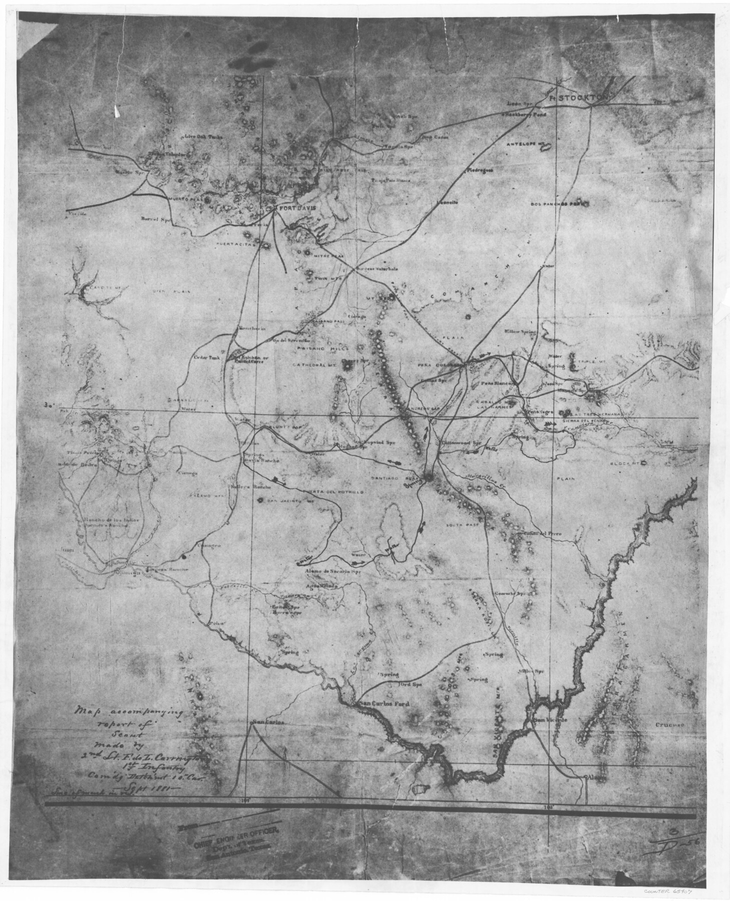
Map accompanying report of scout made by 2nd Lt. F. de I. Carrington. 1st Infantry
K-7-17
-
Map/Doc
65407
-
Collection
General Map Collection
-
Object Dates
1881 (Creation Date)
-
People and Organizations
F. de L. Carrington (Draftsman)
-
Counties
Jeff Davis Pecos Presidio Brewster
-
Subjects
Military
-
Height x Width
22.2 x 18.0 inches
56.4 x 45.7 cm
-
Medium
photostat
-
Comments
Commanding Detachment of the 19th Cavalry
-
Features
Andrew's Gap
Rancheria
Cedar Tank
Painted Caves
San Esteban
San Esteban or Painted Caves
Blunt's Gap
Paisano Hills
Cathedral Mountain
Cherry Springs
Ojo del Arriento
Colinas Springs
Pena Colorado Mountain
Willow Spring
Triple Mountain
Mason's Spring
Pean Negra Mountain
Pena Negro Creek
Las Narices Mountain
Caballo Mountain
Muerto Peak
Leoncito
Piedregoso
Leon Creek
Leon Springs
Hackberry Pond
Fort Stockton
Antelope Mountain
Dos Panchos Peak
Live Oak Tanks
San Francisco Creek
Tinaja Voluntario
Muerto Springs
Viejita
Barrel Springs
Capote Mountain
Mitre Peak
Fort Davis
Puertacitas
Paisano Pass
Canon del Perro
Poho
Potrecilo Creek
Ternera Creek
Alamo de Sacaria Springs
Agua Helada Springs
Burro Spring
Ganen's Spring
Las Lenguas Creek
Muravillas Creek
Canagra
South Pass
Terra Rosilla
Guarache Spring
Tornillo Creek
Cruces
Alamo
San Vicente
Ord Spring
San Carlos Ford
Tinaja Prieto Mountains
Sierra del Venado Mountain
Las Tres Hermana Mountain
Block Mountain
Cottonwood Springs
Santiago Peak
Chopwind Springs
Hughes Spring
Lunt's Gap
Penitas
San Carlos
[ ]ado de Bedra
Alamo Mountains
Cienega
Cibare Creek
Juan
Vallehas Creek
Sjimiga
Del Norte
Part of: General Map Collection
Newton County Sketch File 23

Print $4.00
- Digital $50.00
Newton County Sketch File 23
1855
Size 10.1 x 8.0 inches
Map/Doc 32403
Flight Mission No. CUG-1P, Frame 47, Kleberg County

Print $20.00
- Digital $50.00
Flight Mission No. CUG-1P, Frame 47, Kleberg County
1956
Size 18.7 x 22.4 inches
Map/Doc 86125
Archer County Rolled Sketch B2

Print $20.00
- Digital $50.00
Archer County Rolled Sketch B2
1891
Size 36.7 x 30.7 inches
Map/Doc 5105
Midland County Sketch File 12

Print $20.00
- Digital $50.00
Midland County Sketch File 12
1939
Size 25.4 x 18.6 inches
Map/Doc 12087
Dawson County Sketch File 27

Print $8.00
- Digital $50.00
Dawson County Sketch File 27
Size 12.6 x 8.5 inches
Map/Doc 20588
Calhoun County Sketch File 17

Print $4.00
- Digital $50.00
Calhoun County Sketch File 17
Size 5.1 x 8.4 inches
Map/Doc 35984
Right of Way & Track Map Houston & Brazos Valley Ry. operated by Houston & Brazos Valley Ry. Co., Hoskins Mound Branch

Print $40.00
- Digital $50.00
Right of Way & Track Map Houston & Brazos Valley Ry. operated by Houston & Brazos Valley Ry. Co., Hoskins Mound Branch
1924
Size 25.3 x 56.4 inches
Map/Doc 64611
Val Verde County Working Sketch 117

Print $20.00
- Digital $50.00
Val Verde County Working Sketch 117
1993
Size 34.8 x 37.0 inches
Map/Doc 82843
Flight Mission No. DIX-10P, Frame 182, Aransas County

Print $20.00
- Digital $50.00
Flight Mission No. DIX-10P, Frame 182, Aransas County
1956
Size 18.6 x 22.3 inches
Map/Doc 83972
Panola County Working Sketch 11

Print $20.00
- Digital $50.00
Panola County Working Sketch 11
1944
Map/Doc 71420
Eastland County Working Sketch 13

Print $20.00
- Digital $50.00
Eastland County Working Sketch 13
1919
Size 34.0 x 38.0 inches
Map/Doc 68794
Wilbarger County Working Sketch 22

Print $20.00
- Digital $50.00
Wilbarger County Working Sketch 22
1983
Size 39.8 x 33.6 inches
Map/Doc 72560
You may also like
Section 160, Block G, Gaines County, Texas

Print $20.00
- Digital $50.00
Section 160, Block G, Gaines County, Texas
1958
Size 17.1 x 19.3 inches
Map/Doc 92679
Map of West Hickory Creek, Venango & Warren Cos., Pa.

Print $20.00
- Digital $50.00
Map of West Hickory Creek, Venango & Warren Cos., Pa.
1866
Size 45.7 x 24.7 inches
Map/Doc 94056
Val Verde County Sketch File 39

Print $20.00
- Digital $50.00
Val Verde County Sketch File 39
1939
Size 32.0 x 16.2 inches
Map/Doc 12581
Map of the Missouri, Kansas & Texas Railway and its connecting lines

Print $20.00
- Digital $50.00
Map of the Missouri, Kansas & Texas Railway and its connecting lines
1901
Size 16.3 x 9.1 inches
Map/Doc 95810
San Jacinto County Rolled Sketch 4

Print $20.00
- Digital $50.00
San Jacinto County Rolled Sketch 4
Size 24.3 x 32.6 inches
Map/Doc 7557
Walker County State Real Property Sketch 1

Print $20.00
- Digital $50.00
Walker County State Real Property Sketch 1
2003
Size 35.8 x 30.3 inches
Map/Doc 78585
Mills County Boundary File 1a

Print $60.00
- Digital $50.00
Mills County Boundary File 1a
Size 9.7 x 31.6 inches
Map/Doc 57273
Clay County Sketch File 22

Print $6.00
- Digital $50.00
Clay County Sketch File 22
Size 12.8 x 8.3 inches
Map/Doc 18436
Van Zandt County Sketch File 47

Print $7.00
- Digital $50.00
Van Zandt County Sketch File 47
Size 10.0 x 8.1 inches
Map/Doc 39504
This Map Shows the Surveys 61 to 69 by Dod's Monuments in Accordance with Dod's Course in Stanolind vs. State

Print $2.00
- Digital $50.00
This Map Shows the Surveys 61 to 69 by Dod's Monuments in Accordance with Dod's Course in Stanolind vs. State
Size 15.7 x 9.0 inches
Map/Doc 91687
Flight Mission No. BQY-14M, Frame 180, Harris County

Print $20.00
- Digital $50.00
Flight Mission No. BQY-14M, Frame 180, Harris County
1953
Size 18.6 x 22.4 inches
Map/Doc 85296
Goliad County Boundary File 33

Print $12.00
- Digital $50.00
Goliad County Boundary File 33
Size 9.4 x 4.2 inches
Map/Doc 53797