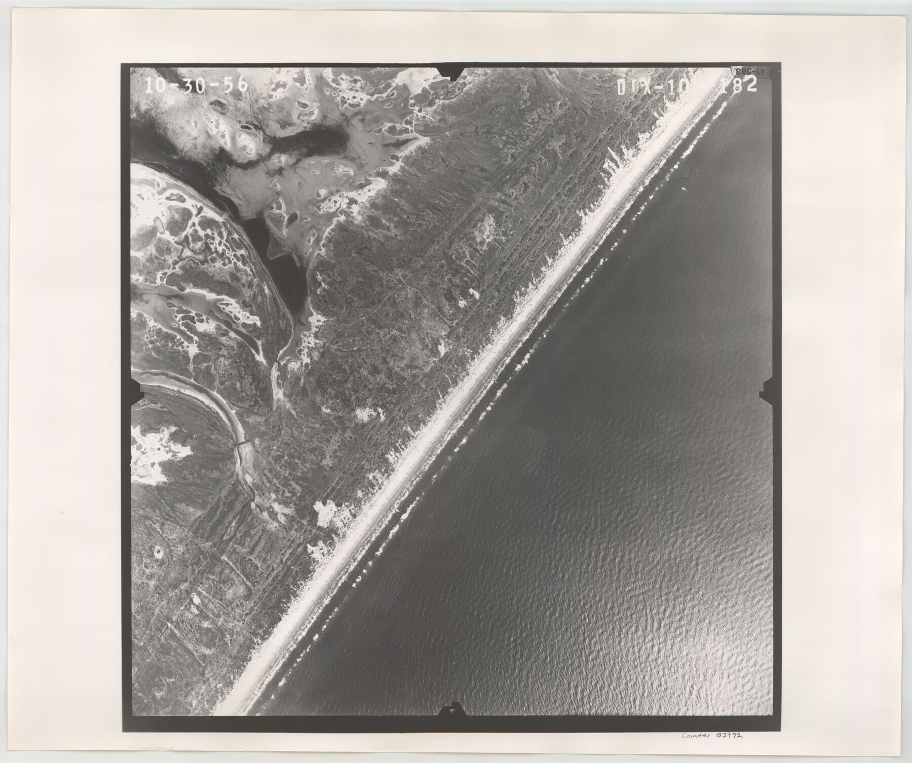
Flight Mission No. DIX-10P, Frame 182, Aransas County
DIX-10P-182
-
Map/Doc
83972
-
Collection
General Map Collection
-
Object Dates
1956/10/30 (Creation Date)
-
People and Organizations
U. S. Department of Agriculture (Publisher)
-
Counties
Aransas
-
Subjects
Aerial Photograph
-
Height x Width
18.6 x 22.3 inches
47.2 x 56.6 cm
-
Comments
Flown by V. L. Beavers and Associates of San Antonio, Texas.
Part of: General Map Collection
South Montgomery County, Woodlands Chamber of Commerce Street Map

South Montgomery County, Woodlands Chamber of Commerce Street Map
Size 50.0 x 37.8 inches
Map/Doc 94364
Gray County Sketch File 11

Print $40.00
- Digital $50.00
Gray County Sketch File 11
Size 15.0 x 13.5 inches
Map/Doc 24452
Lee County Rolled Sketch 1

Print $40.00
- Digital $50.00
Lee County Rolled Sketch 1
1939
Size 71.1 x 45.2 inches
Map/Doc 9562
Flight Mission No. CUG-1P, Frame 106, Kleberg County

Print $20.00
- Digital $50.00
Flight Mission No. CUG-1P, Frame 106, Kleberg County
1956
Size 18.8 x 22.3 inches
Map/Doc 86156
Gallup's Map of Texas

Print $20.00
- Digital $50.00
Gallup's Map of Texas
1920
Size 22.4 x 31.9 inches
Map/Doc 95696
Edwards County Working Sketch Graphic Index - west part

Print $40.00
- Digital $50.00
Edwards County Working Sketch Graphic Index - west part
1975
Size 57.4 x 38.1 inches
Map/Doc 76532
Kleberg County

Print $20.00
- Digital $50.00
Kleberg County
1913
Size 31.3 x 40.1 inches
Map/Doc 77343
Midland County Rolled Sketch 7

Print $40.00
- Digital $50.00
Midland County Rolled Sketch 7
1951
Size 77.3 x 25.2 inches
Map/Doc 9519
Dallam County Sketch File 10

Print $20.00
- Digital $50.00
Dallam County Sketch File 10
1925
Size 7.2 x 8.6 inches
Map/Doc 20367
Sterling County Sketch File 1

Print $40.00
- Digital $50.00
Sterling County Sketch File 1
1862
Size 18.7 x 8.4 inches
Map/Doc 37111
Runnels County Working Sketch 13

Print $20.00
- Digital $50.00
Runnels County Working Sketch 13
1950
Size 19.4 x 17.8 inches
Map/Doc 63609
Gaines County Rolled Sketch 32

Print $20.00
- Digital $50.00
Gaines County Rolled Sketch 32
1902
Size 20.5 x 29.9 inches
Map/Doc 5945
You may also like
Caldwell County Working Sketch 1

Print $20.00
- Digital $50.00
Caldwell County Working Sketch 1
Size 20.7 x 26.2 inches
Map/Doc 67831
Sketch of Block A7, Hartley County, Texas

Print $20.00
- Digital $50.00
Sketch of Block A7, Hartley County, Texas
1905
Size 10.2 x 22.1 inches
Map/Doc 90756
Jefferson County Rolled Sketch 6

Print $20.00
- Digital $50.00
Jefferson County Rolled Sketch 6
1916
Size 34.2 x 36.7 inches
Map/Doc 9271
[Surveys 111-114, north of Morris County School Land]
![90362, [Surveys 111-114, north of Morris County School Land], Twichell Survey Records](https://historictexasmaps.com/wmedia_w700/maps/90362-1.tif.jpg)
Print $20.00
- Digital $50.00
[Surveys 111-114, north of Morris County School Land]
Size 23.7 x 8.2 inches
Map/Doc 90362
San Jacinto County Working Sketch 22

Print $20.00
- Digital $50.00
San Jacinto County Working Sketch 22
1940
Size 21.3 x 25.3 inches
Map/Doc 63735
A Sketch of the Vice Royalty exhibiting the several Provinces and its Aproximation [sic] to the Internal Provinces of New Spain
![95157, A Sketch of the Vice Royalty exhibiting the several Provinces and its Aproximation [sic] to the Internal Provinces of New Spain, General Map Collection](https://historictexasmaps.com/wmedia_w700/maps/95157.tif.jpg)
Print $20.00
- Digital $50.00
A Sketch of the Vice Royalty exhibiting the several Provinces and its Aproximation [sic] to the Internal Provinces of New Spain
1810
Size 15.2 x 21.1 inches
Map/Doc 95157
Flight Mission No. BRA-6M, Frame 91, Jefferson County

Print $20.00
- Digital $50.00
Flight Mission No. BRA-6M, Frame 91, Jefferson County
1953
Size 18.5 x 22.4 inches
Map/Doc 85434

Sherman County Sketch File 5

Print $2.00
- Digital $50.00
Sherman County Sketch File 5
1993
Size 14.6 x 9.0 inches
Map/Doc 36723
Midland County Working Sketch 9

Print $20.00
- Digital $50.00
Midland County Working Sketch 9
1951
Size 42.6 x 35.9 inches
Map/Doc 70989
Refugio County Texas

Print $20.00
- Digital $50.00
Refugio County Texas
1896
Size 20.3 x 26.9 inches
Map/Doc 3985
[Oil and Gas Fields in West Texas]
![89884, [Oil and Gas Fields in West Texas], Twichell Survey Records](https://historictexasmaps.com/wmedia_w700/maps/89884-1.tif.jpg)
Print $40.00
- Digital $50.00
[Oil and Gas Fields in West Texas]
Size 38.5 x 59.2 inches
Map/Doc 89884