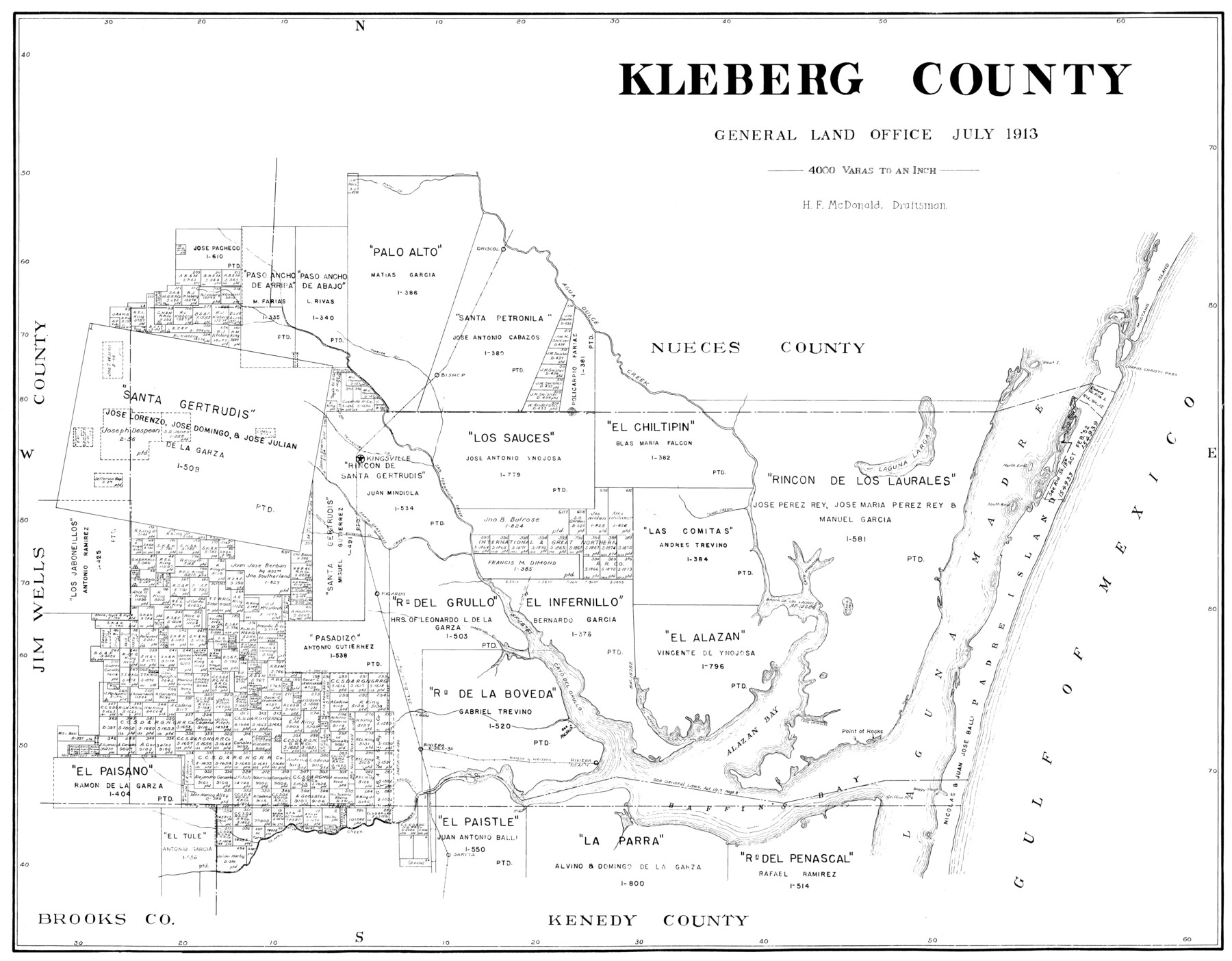
Kleberg County
-
Map/Doc
77343
-
Collection
General Map Collection
-
Object Dates
1913 (Creation Date)
-
Counties
Kleberg
-
Subjects
County
-
Height x Width
31.3 x 40.1 inches
79.5 x 101.9 cm
Part of: General Map Collection
Refugio County Sketch File 20

Print $8.00
- Digital $50.00
Refugio County Sketch File 20
Size 14.4 x 8.8 inches
Map/Doc 35276
Navarro County Sketch File 7

Print $4.00
- Digital $50.00
Navarro County Sketch File 7
1854
Size 12.2 x 8.0 inches
Map/Doc 32313
Texas, Matagorda Bay, Port O'Connor to Gallinipper Point

Print $40.00
- Digital $50.00
Texas, Matagorda Bay, Port O'Connor to Gallinipper Point
1933
Size 31.1 x 48.6 inches
Map/Doc 69985
Presidio County Sketch File 115

Print $14.00
- Digital $50.00
Presidio County Sketch File 115
1993
Size 11.3 x 8.9 inches
Map/Doc 34835
Brazoria County Working Sketch 31

Print $20.00
- Digital $50.00
Brazoria County Working Sketch 31
1977
Size 26.3 x 31.7 inches
Map/Doc 67516
Jim Hogg County Rolled Sketch 5

Print $20.00
- Digital $50.00
Jim Hogg County Rolled Sketch 5
1943
Size 19.9 x 24.1 inches
Map/Doc 6441
Ector County Rolled Sketch RE1

Print $20.00
- Digital $50.00
Ector County Rolled Sketch RE1
1928
Size 41.6 x 40.0 inches
Map/Doc 8834
Jeff Davis County Working Sketch 35

Print $20.00
- Digital $50.00
Jeff Davis County Working Sketch 35
1979
Size 34.4 x 36.9 inches
Map/Doc 66530
Bailey County Sketch File 5

Print $40.00
- Digital $50.00
Bailey County Sketch File 5
1907
Size 31.9 x 22.8 inches
Map/Doc 10883
Right of Way and Track Map Houston & Texas Central R.R. operated by the T. and N. O. R.R. Co., Fort Worth Branch

Print $40.00
- Digital $50.00
Right of Way and Track Map Houston & Texas Central R.R. operated by the T. and N. O. R.R. Co., Fort Worth Branch
1918
Size 31.4 x 58.5 inches
Map/Doc 64544
Sabine County

Print $20.00
- Digital $50.00
Sabine County
1920
Size 45.7 x 36.1 inches
Map/Doc 95631
Runnels County

Print $40.00
- Digital $50.00
Runnels County
1948
Size 48.8 x 38.8 inches
Map/Doc 73278
You may also like
Hardin County Working Sketch 28

Print $20.00
- Digital $50.00
Hardin County Working Sketch 28
1956
Size 18.8 x 18.9 inches
Map/Doc 63426
Map of Dallas & Wichita Railroad Survey

Print $40.00
- Digital $50.00
Map of Dallas & Wichita Railroad Survey
1874
Size 37.3 x 82.7 inches
Map/Doc 64417
Pecos County Rolled Sketch 77

Print $20.00
- Digital $50.00
Pecos County Rolled Sketch 77
1930
Size 38.4 x 23.4 inches
Map/Doc 7238
Navasota and Grimes County, Texas

Navasota and Grimes County, Texas
Size 25.8 x 28.5 inches
Map/Doc 96865
Location of the Southern Kansas Railway of Texas, Gray County, Texas

Print $40.00
- Digital $50.00
Location of the Southern Kansas Railway of Texas, Gray County, Texas
1887
Size 19.9 x 75.3 inches
Map/Doc 64036

Val Verde County Sketch File 45

Print $20.00
- Digital $50.00
Val Verde County Sketch File 45
1938
Size 21.3 x 16.5 inches
Map/Doc 12586
Atascosa County Sketch File 9

Print $4.00
- Digital $50.00
Atascosa County Sketch File 9
1858
Size 8.1 x 12.6 inches
Map/Doc 13763
Upshur County Working Sketch 10

Print $20.00
- Digital $50.00
Upshur County Working Sketch 10
1969
Size 42.1 x 37.0 inches
Map/Doc 69566
Limestone County

Print $40.00
- Digital $50.00
Limestone County
1922
Size 50.6 x 36.2 inches
Map/Doc 73342
Map of Texas with population and location of principal towns and cities according to latest reliable statistics

Print $20.00
- Digital $50.00
Map of Texas with population and location of principal towns and cities according to latest reliable statistics
1921
Size 19.0 x 22.2 inches
Map/Doc 94066
McMullen County Rolled Sketch 15

Print $20.00
- Digital $50.00
McMullen County Rolled Sketch 15
1948
Size 30.9 x 25.9 inches
Map/Doc 6732