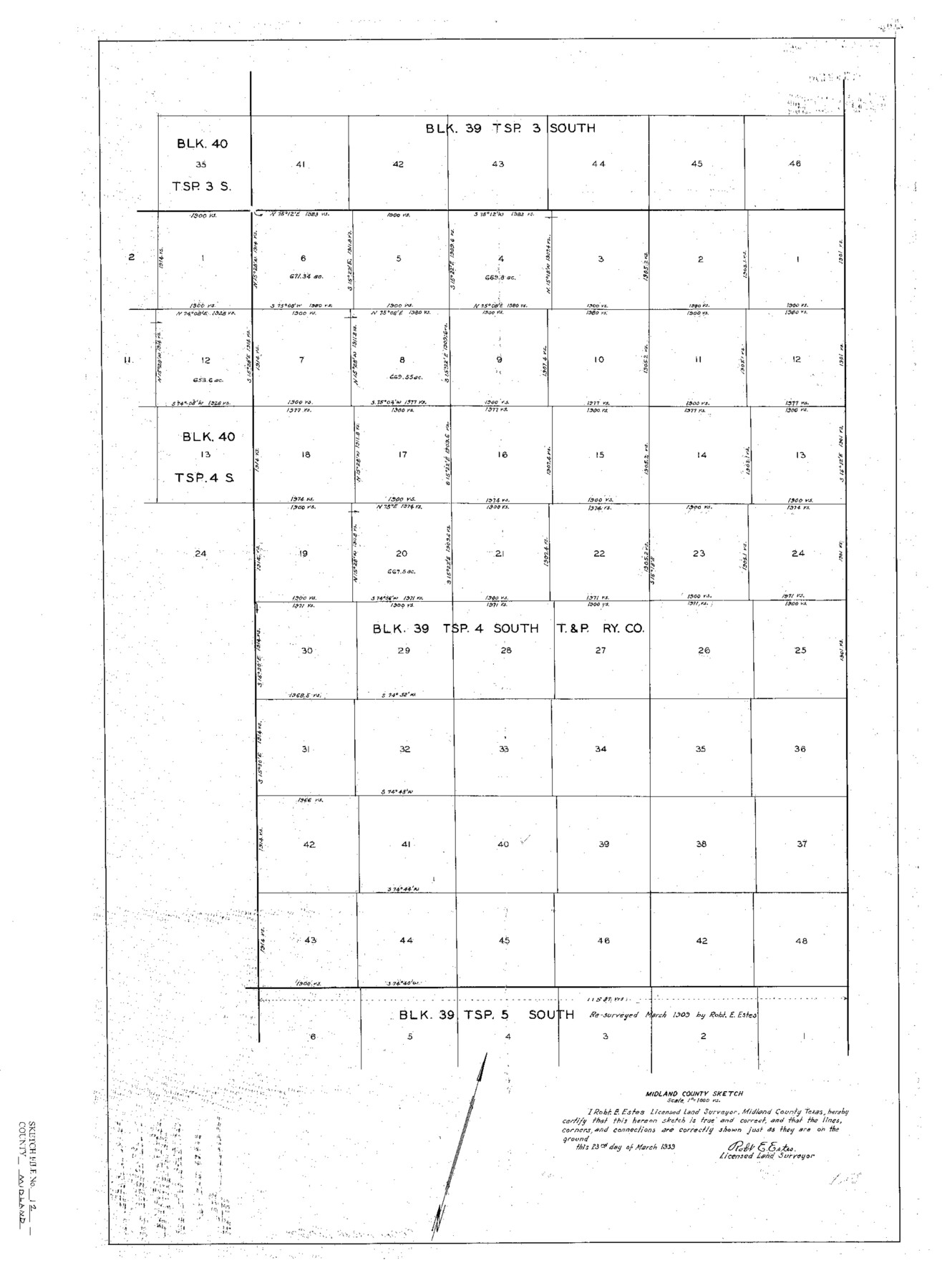
Midland County Sketch File 12
Block 39, Tsp. 4 South, Midland County, Texas
-
Map/Doc
12087
-
Collection
General Map Collection
-
Object Dates
3/23/1939 (Creation Date)
3/28/1939 (File Date)
-
People and Organizations
Robert E. Estes (Surveyor/Engineer)
-
Counties
Midland Upton
-
Subjects
Surveying Sketch File
-
Height x Width
25.4 x 18.6 inches
64.5 x 47.2 cm
-
Medium
paper, print
-
Scale
1" = 1000 varas
Part of: General Map Collection
Flight Mission No. DQO-3K, Frame 32, Galveston County

Print $20.00
- Digital $50.00
Flight Mission No. DQO-3K, Frame 32, Galveston County
1952
Size 18.7 x 22.5 inches
Map/Doc 85073
South Sulphur River, Bonner Point Sheet

Print $20.00
- Digital $50.00
South Sulphur River, Bonner Point Sheet
1922
Size 32.9 x 35.7 inches
Map/Doc 65164
Current Miscellaneous File 90

Print $18.00
- Digital $50.00
Current Miscellaneous File 90
1956
Size 11.2 x 8.8 inches
Map/Doc 74255
No. 1 - Survey for a road from the Brazo Santiago to the Rio Grande

Print $20.00
- Digital $50.00
No. 1 - Survey for a road from the Brazo Santiago to the Rio Grande
1847
Size 18.3 x 27.0 inches
Map/Doc 72873
Irion County Sketch File 9

Print $14.00
- Digital $50.00
Irion County Sketch File 9
1927
Size 11.0 x 8.5 inches
Map/Doc 27475
San Patricio County Working Sketch 19

Print $20.00
- Digital $50.00
San Patricio County Working Sketch 19
1956
Size 36.1 x 41.3 inches
Map/Doc 63781
Travis County Rolled Sketch 5

Print $20.00
- Digital $50.00
Travis County Rolled Sketch 5
1924
Size 24.1 x 27.9 inches
Map/Doc 8011
El Paso County Rolled Sketch 57B

Print $40.00
- Digital $50.00
El Paso County Rolled Sketch 57B
1984
Size 49.0 x 37.1 inches
Map/Doc 8880
Dickens County Working Sketch 1

Print $20.00
- Digital $50.00
Dickens County Working Sketch 1
Size 15.5 x 15.5 inches
Map/Doc 68648
Wilbarger Co.

Print $40.00
- Digital $50.00
Wilbarger Co.
1949
Size 48.2 x 38.8 inches
Map/Doc 95674
Calhoun County Sketch File 2

Print $40.00
- Digital $50.00
Calhoun County Sketch File 2
1856
Size 20.2 x 15.8 inches
Map/Doc 11032
Henderson County Boundary File 3c

Print $40.00
- Digital $50.00
Henderson County Boundary File 3c
Size 22.5 x 80.6 inches
Map/Doc 54707
You may also like
Subdivision of the East Half of Lot No. 1 in Division "Z" of the Out-Lots adjoining the City of Austin

Print $20.00
- Digital $50.00
Subdivision of the East Half of Lot No. 1 in Division "Z" of the Out-Lots adjoining the City of Austin
Size 32.1 x 42.6 inches
Map/Doc 648
Padre Island National Seashore

Print $4.00
- Digital $50.00
Padre Island National Seashore
Size 16.0 x 22.1 inches
Map/Doc 60528
Morris County Rolled Sketch 2A

Print $20.00
- Digital $50.00
Morris County Rolled Sketch 2A
Size 24.0 x 18.7 inches
Map/Doc 10286
Crane County Boundary File 1a

Print $18.00
- Digital $50.00
Crane County Boundary File 1a
Size 14.2 x 8.7 inches
Map/Doc 51960
United States Great Lakes and adjacent waterways

Print $20.00
- Digital $50.00
United States Great Lakes and adjacent waterways
Size 20.8 x 42.7 inches
Map/Doc 76122
Hemphill County Working Sketch 32

Print $20.00
- Digital $50.00
Hemphill County Working Sketch 32
1976
Size 45.8 x 34.2 inches
Map/Doc 66127

Dickens County Sketch File 22

Print $8.00
- Digital $50.00
Dickens County Sketch File 22
1913
Size 11.2 x 9.1 inches
Map/Doc 20985
[Sections 77-114, Block 47 and part of G. & M. Blocks 2 and 3]
![91827, [Sections 77-114, Block 47 and part of G. & M. Blocks 2 and 3], Twichell Survey Records](https://historictexasmaps.com/wmedia_w700/maps/91827-1.tif.jpg)
Print $20.00
- Digital $50.00
[Sections 77-114, Block 47 and part of G. & M. Blocks 2 and 3]
Size 38.1 x 19.8 inches
Map/Doc 91827
General Highway Map, Brooks County, Texas

Print $20.00
General Highway Map, Brooks County, Texas
1961
Size 18.2 x 24.8 inches
Map/Doc 79388
Morley's Map of New Mexico compiled from the latest government surveys and other reliable sources

Print $20.00
- Digital $50.00
Morley's Map of New Mexico compiled from the latest government surveys and other reliable sources
1873
Size 26.2 x 28.0 inches
Map/Doc 94052
Willie Winn Tract

Print $2.00
- Digital $50.00
Willie Winn Tract
1903
Size 5.9 x 7.6 inches
Map/Doc 92285