[Surveying Sketch of M. Farley, R. Word, S. S. Hervey, et al in Kleberg County, Texas]
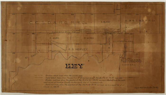
Print $20.00
- Digital $50.00
[Surveying Sketch of M. Farley, R. Word, S. S. Hervey, et al in Kleberg County, Texas]
Size: 23.2 x 40.6 inches
10783
[Sketch with field note calls of the boundaries of Webb, Duval, Jim Wells,Nueces, Kleberg, Zapata, Jim Hogg, Brooks, Willacy, Starr, Hidalgo and Cameron Counties]
![1689, [Sketch with field note calls of the boundaries of Webb, Duval, Jim Wells,Nueces, Kleberg, Zapata, Jim Hogg, Brooks, Willacy, Starr, Hidalgo and Cameron Counties], General Map Collection](https://historictexasmaps.com/wmedia_w700/pdf_converted_jpg/qi_pdf_thumbnail_720.jpg)
Print $20.00
- Digital $50.00
[Sketch with field note calls of the boundaries of Webb, Duval, Jim Wells,Nueces, Kleberg, Zapata, Jim Hogg, Brooks, Willacy, Starr, Hidalgo and Cameron Counties]
1915
Size: 21.9 x 26.2 inches
1689
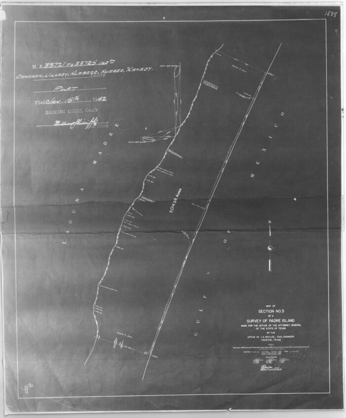
[Sketch for Mineral Application 33721 - 33725 Incl. - Padre and Mustang Island]
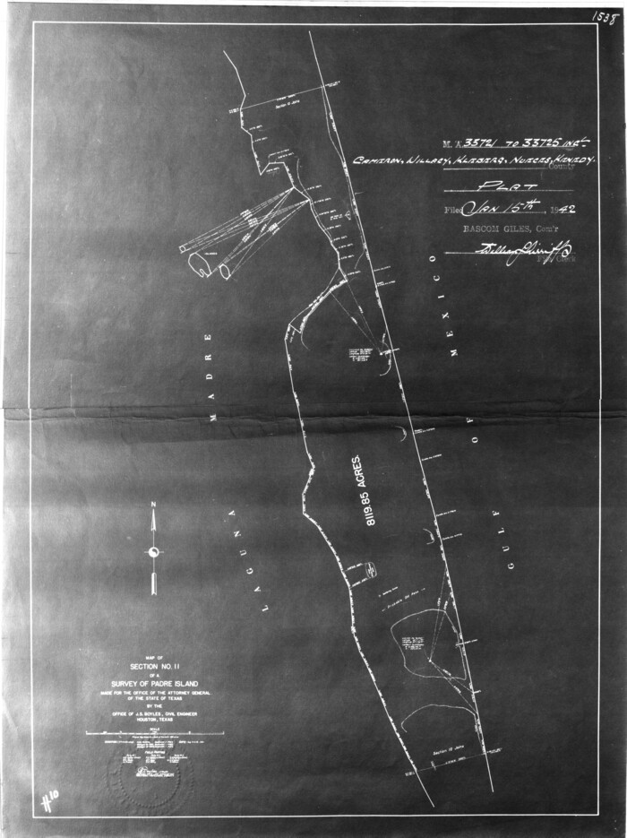
Print $20.00
- Digital $50.00
[Sketch for Mineral Application 33721 - 33725 Incl. - Padre and Mustang Island]
1942
Size: 29.7 x 22.3 inches
2868
[Sketch for Mineral Application 33721 - 33725 Incl. - Padre and Mustang Island]
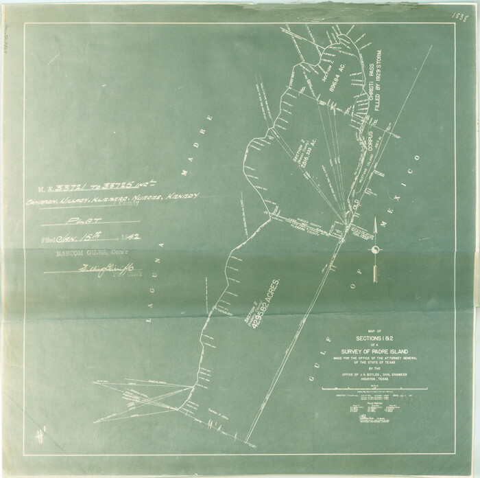
Print $20.00
- Digital $50.00
[Sketch for Mineral Application 33721 - 33725 Incl. - Padre and Mustang Island]
1942
Size: 22.2 x 22.3 inches
2869
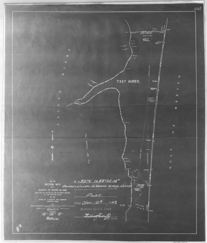
[Sketch for Mineral Application 33721 - 33725 Incl. - Padre and Mustang Island]
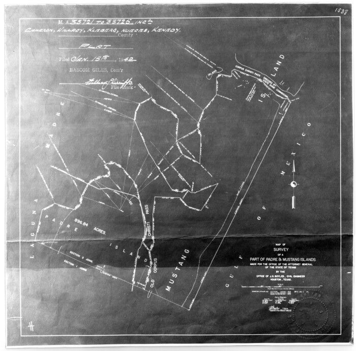
Print $20.00
- Digital $50.00
[Sketch for Mineral Application 33721 - 33725 Incl. - Padre and Mustang Island]
1942
Size: 22.1 x 22.4 inches
2870
[Sketch for Mineral Application 33721 - 33725 Incl. - Padre and Mustang Island]
Print $20.00
- Digital $50.00
[Sketch for Mineral Application 33721 - 33725 Incl. - Padre and Mustang Island]
1942
Size: 27.0 x 22.4 inches
2871
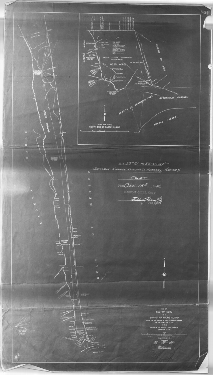
[Sketch for Mineral Application 33721 - 33725 Incl. - Padre and Mustang Island]
Print $20.00
- Digital $50.00
[Sketch for Mineral Application 33721 - 33725 Incl. - Padre and Mustang Island]
1942
Size: 26.6 x 22.7 inches
2873
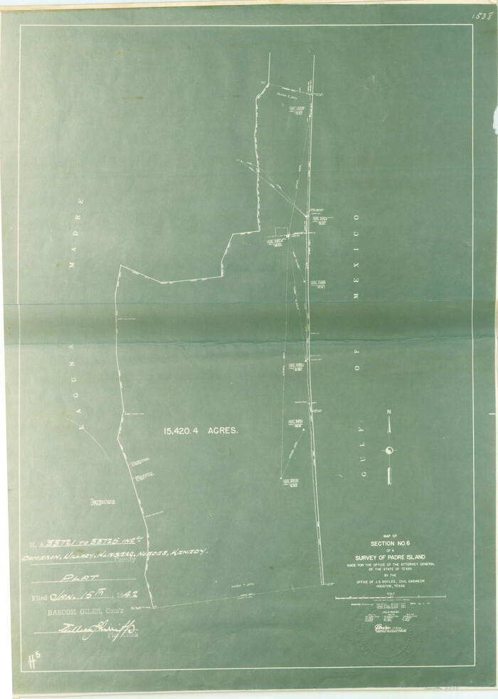
[Sketch for Mineral Application 33721 - 33725 Incl. - Padre and Mustang Island]
Print $20.00
- Digital $50.00
[Sketch for Mineral Application 33721 - 33725 Incl. - Padre and Mustang Island]
1941
Size: 40.2 x 22.8 inches
2874
[Sketch for Mineral Application 33721 - 33725 Incl. - Padre and Mustang Island]
Print $20.00
- Digital $50.00
[Sketch for Mineral Application 33721 - 33725 Incl. - Padre and Mustang Island]
1942
Size: 30.9 x 22.0 inches
2875
[Sketch for Mineral Application 33721 - 33725 Incl. - Padre and Mustang Island]
Print $20.00
- Digital $50.00
[Sketch for Mineral Application 33721 - 33725 Incl. - Padre and Mustang Island]
1942
Size: 29.1 x 23.0 inches
2876
[Sketch for Mineral Application 33721 - 33725 Incl. - Padre and Mustang Island]
Print $20.00
- Digital $50.00
[Sketch for Mineral Application 33721 - 33725 Incl. - Padre and Mustang Island]
1942
Size: 29.8 x 22.6 inches
2877
[Sketch for Mineral Application 33721 - 33725 Incl. - Padre and Mustang Island]

Print $20.00
- Digital $50.00
[Sketch for Mineral Application 33721 - 33725 Incl. - Padre and Mustang Island]
1942
Size: 29.8 x 22.7 inches
2878
[Sketch for Mineral Application 33721 - 33725 Incl. - Padre and Mustang Island]
Print $20.00
- Digital $50.00
[Sketch for Mineral Application 33721 - 33725 Incl. - Padre and Mustang Island]
1942
Size: 29.4 x 22.2 inches
2879
[Sketch for Mineral Application 33721 - 33725 Incl. - Padre and Mustang Island]
Print $20.00
- Digital $50.00
[Sketch for Mineral Application 33721 - 33725 Incl. - Padre and Mustang Island]
Size: 42.3 x 22.6 inches
65664
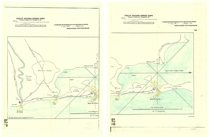
[Old Coastal Chart showing Brazo Chico, Brazo de Santiago and Rio Bravo del Norte passes with depth readings]
Print $20.00
- Digital $50.00
[Old Coastal Chart showing Brazo Chico, Brazo de Santiago and Rio Bravo del Norte passes with depth readings]
1837
Size: 25.7 x 39.3 inches
4661
[Map of the City of South Padre Island]
Print $20.00
- Digital $50.00
[Map of the City of South Padre Island]
1993
Size: 12.5 x 36.5 inches
3212
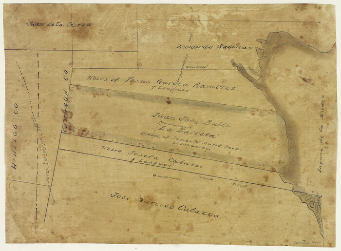
[Juan Jose Balli Survey, Kenedy County, Texas]
Print $3.00
- Digital $50.00
[Juan Jose Balli Survey, Kenedy County, Texas]
Size: 9.8 x 13.4 inches
4444
Texas Intracoastal Waterway - Stover Point to Port Brownsville including Brazos Santiago

Print $20.00
- Digital $50.00
Texas Intracoastal Waterway - Stover Point to Port Brownsville including Brazos Santiago
1957
Size: 27.6 x 38.9 inches
73518
Texas Intracoastal Waterway - Stover Point to Port Brownsville including Brazos Santiago

Print $20.00
- Digital $50.00
Texas Intracoastal Waterway - Stover Point to Port Brownsville including Brazos Santiago
1961
Size: 27.2 x 38.9 inches
73519
Texas Intracoastal Waterway - Stover Point to Port Brownsville including Brazos Santiago

Print $20.00
- Digital $50.00
Texas Intracoastal Waterway - Stover Point to Port Brownsville including Brazos Santiago
1962
Size: 27.8 x 38.9 inches
73520
Texas Intracoastal Waterway - Stover Point to Port Brownsville including Brazos Santiago

Print $20.00
- Digital $50.00
Texas Intracoastal Waterway - Stover Point to Port Brownsville including Brazos Santiago
1965
Size: 27.5 x 38.9 inches
73521
Texas Intracoastal Waterway - Laguna Madre - Rincon de San Jose to Chubby Island

Print $20.00
- Digital $50.00
Texas Intracoastal Waterway - Laguna Madre - Rincon de San Jose to Chubby Island
1957
Size: 38.9 x 27.3 inches
73513
Texas Intracoastal Waterway - Laguna Madre - Rincon de San Jose to Chubby Island

Print $20.00
- Digital $50.00
Texas Intracoastal Waterway - Laguna Madre - Rincon de San Jose to Chubby Island
1961
Size: 38.7 x 27.5 inches
73515
Texas Gulf Coast, from the Sabine River to the Rio Grande as Subdivided for Mineral Development; Aransas, Nueces, Kleberg, Kenedy, Willacy, and Cameron Counties

Print $40.00
- Digital $50.00
Texas Gulf Coast, from the Sabine River to the Rio Grande as Subdivided for Mineral Development; Aransas, Nueces, Kleberg, Kenedy, Willacy, and Cameron Counties
1976
Size: 118.0 x 43.0 inches
1940
Texas Gulf Coast Map from the Sabine River to the Rio Grande as subdivided for mineral development

Print $40.00
- Digital $50.00
Texas Gulf Coast Map from the Sabine River to the Rio Grande as subdivided for mineral development
Size: 117.9 x 46.0 inches
2902
St. Louis, Brownsville & Mexico Railway Location map from Mile 40 to Mile 60

Print $40.00
- Digital $50.00
St. Louis, Brownsville & Mexico Railway Location map from Mile 40 to Mile 60
1905
Size: 19.6 x 74.9 inches
64079
St. Louis, Brownsville & Mexico Railway Location map from Mile 40 to Mile 60

Print $40.00
- Digital $50.00
St. Louis, Brownsville & Mexico Railway Location map from Mile 40 to Mile 60
1905
Size: 19.3 x 61.9 inches
64080
St. Louis, Brownsville & Mexico Railway Location Map from Mile 40 to Mile 60

Print $40.00
- Digital $50.00
St. Louis, Brownsville & Mexico Railway Location Map from Mile 40 to Mile 60
1905
Size: 20.3 x 136.1 inches
89282
St. Louis, Brownsville & Mexico Railway Location Map from Mile 20 to Mile 40

Print $40.00
- Digital $50.00
St. Louis, Brownsville & Mexico Railway Location Map from Mile 20 to Mile 40
1906
Size: 19.3 x 67.5 inches
64077
[Surveying Sketch of M. Farley, R. Word, S. S. Hervey, et al in Kleberg County, Texas]
Print $20.00
- Digital $50.00
[Surveying Sketch of M. Farley, R. Word, S. S. Hervey, et al in Kleberg County, Texas]
-
Size
23.2 x 40.6 inches
-
Map/Doc
10783
[Sketch with field note calls of the boundaries of Webb, Duval, Jim Wells,Nueces, Kleberg, Zapata, Jim Hogg, Brooks, Willacy, Starr, Hidalgo and Cameron Counties]
Print $20.00
- Digital $50.00
[Sketch with field note calls of the boundaries of Webb, Duval, Jim Wells,Nueces, Kleberg, Zapata, Jim Hogg, Brooks, Willacy, Starr, Hidalgo and Cameron Counties]
1915
-
Size
21.9 x 26.2 inches
-
Map/Doc
1689
-
Creation Date
1915
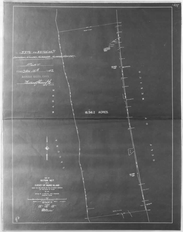
[Sketch for Mineral Application 33721 - 33725 Incl. - Padre and Mustang Island]
Print $20.00
- Digital $50.00
[Sketch for Mineral Application 33721 - 33725 Incl. - Padre and Mustang Island]
1942
-
Size
29.7 x 22.3 inches
-
Map/Doc
2868
-
Creation Date
1942
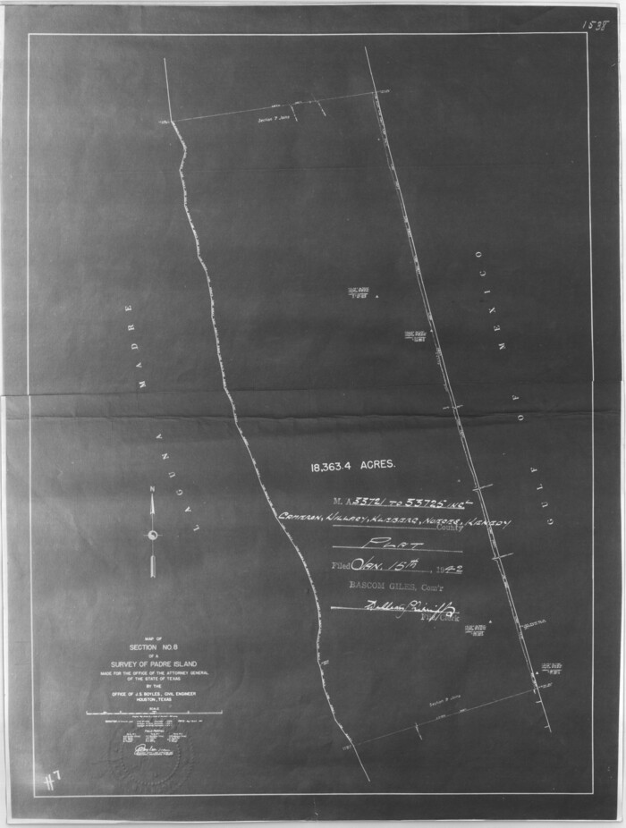
[Sketch for Mineral Application 33721 - 33725 Incl. - Padre and Mustang Island]
Print $20.00
- Digital $50.00
[Sketch for Mineral Application 33721 - 33725 Incl. - Padre and Mustang Island]
1942
-
Size
22.2 x 22.3 inches
-
Map/Doc
2869
-
Creation Date
1942
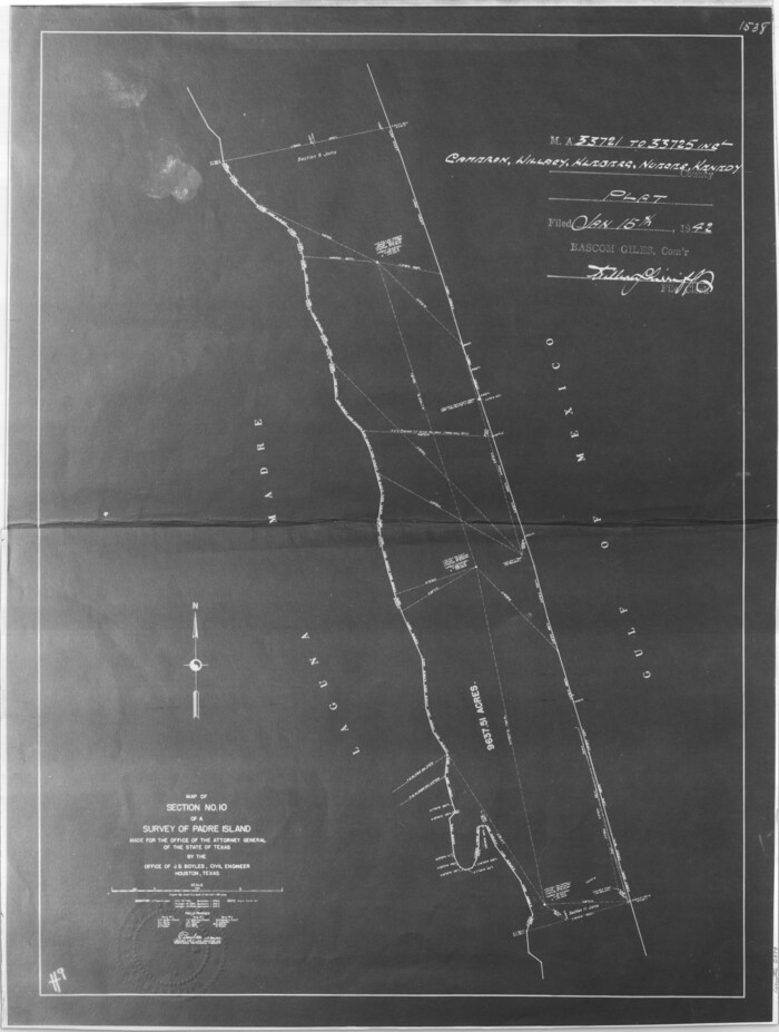
[Sketch for Mineral Application 33721 - 33725 Incl. - Padre and Mustang Island]
Print $20.00
- Digital $50.00
[Sketch for Mineral Application 33721 - 33725 Incl. - Padre and Mustang Island]
1942
-
Size
22.1 x 22.4 inches
-
Map/Doc
2870
-
Creation Date
1942
[Sketch for Mineral Application 33721 - 33725 Incl. - Padre and Mustang Island]
Print $20.00
- Digital $50.00
[Sketch for Mineral Application 33721 - 33725 Incl. - Padre and Mustang Island]
1942
-
Size
27.0 x 22.4 inches
-
Map/Doc
2871
-
Creation Date
1942
[Sketch for Mineral Application 33721 - 33725 Incl. - Padre and Mustang Island]
Print $20.00
- Digital $50.00
[Sketch for Mineral Application 33721 - 33725 Incl. - Padre and Mustang Island]
1942
-
Size
26.6 x 22.7 inches
-
Map/Doc
2873
-
Creation Date
1942
[Sketch for Mineral Application 33721 - 33725 Incl. - Padre and Mustang Island]
Print $20.00
- Digital $50.00
[Sketch for Mineral Application 33721 - 33725 Incl. - Padre and Mustang Island]
1941
-
Size
40.2 x 22.8 inches
-
Map/Doc
2874
-
Creation Date
1941
[Sketch for Mineral Application 33721 - 33725 Incl. - Padre and Mustang Island]
Print $20.00
- Digital $50.00
[Sketch for Mineral Application 33721 - 33725 Incl. - Padre and Mustang Island]
1942
-
Size
30.9 x 22.0 inches
-
Map/Doc
2875
-
Creation Date
1942
[Sketch for Mineral Application 33721 - 33725 Incl. - Padre and Mustang Island]
Print $20.00
- Digital $50.00
[Sketch for Mineral Application 33721 - 33725 Incl. - Padre and Mustang Island]
1942
-
Size
29.1 x 23.0 inches
-
Map/Doc
2876
-
Creation Date
1942
[Sketch for Mineral Application 33721 - 33725 Incl. - Padre and Mustang Island]
Print $20.00
- Digital $50.00
[Sketch for Mineral Application 33721 - 33725 Incl. - Padre and Mustang Island]
1942
-
Size
29.8 x 22.6 inches
-
Map/Doc
2877
-
Creation Date
1942
[Sketch for Mineral Application 33721 - 33725 Incl. - Padre and Mustang Island]
Print $20.00
- Digital $50.00
[Sketch for Mineral Application 33721 - 33725 Incl. - Padre and Mustang Island]
1942
-
Size
29.8 x 22.7 inches
-
Map/Doc
2878
-
Creation Date
1942
[Sketch for Mineral Application 33721 - 33725 Incl. - Padre and Mustang Island]
Print $20.00
- Digital $50.00
[Sketch for Mineral Application 33721 - 33725 Incl. - Padre and Mustang Island]
1942
-
Size
29.4 x 22.2 inches
-
Map/Doc
2879
-
Creation Date
1942
[Sketch for Mineral Application 33721 - 33725 Incl. - Padre and Mustang Island]
Print $20.00
- Digital $50.00
[Sketch for Mineral Application 33721 - 33725 Incl. - Padre and Mustang Island]
-
Size
42.3 x 22.6 inches
-
Map/Doc
65664
[Old Coastal Chart showing Brazo Chico, Brazo de Santiago and Rio Bravo del Norte passes with depth readings]
Print $20.00
- Digital $50.00
[Old Coastal Chart showing Brazo Chico, Brazo de Santiago and Rio Bravo del Norte passes with depth readings]
1837
-
Size
25.7 x 39.3 inches
-
Map/Doc
4661
-
Creation Date
1837
[Map of the City of South Padre Island]
Print $20.00
- Digital $50.00
[Map of the City of South Padre Island]
1993
-
Size
12.5 x 36.5 inches
-
Map/Doc
3212
-
Creation Date
1993
[Juan Jose Balli Survey, Kenedy County, Texas]
Print $3.00
- Digital $50.00
[Juan Jose Balli Survey, Kenedy County, Texas]
-
Size
9.8 x 13.4 inches
-
Map/Doc
4444
[Cameron County]
![3365, [Cameron County], General Map Collection](https://historictexasmaps.com/wmedia_w700/maps/3365-2.tif.jpg)
Print $20.00
- Digital $50.00
[Cameron County]
-
Size
19.2 x 21.8 inches
-
Map/Doc
3365
Texas Intracoastal Waterway - Stover Point to Port Brownsville including Brazos Santiago
Print $20.00
- Digital $50.00
Texas Intracoastal Waterway - Stover Point to Port Brownsville including Brazos Santiago
1957
-
Size
27.6 x 38.9 inches
-
Map/Doc
73518
-
Creation Date
1957
Texas Intracoastal Waterway - Stover Point to Port Brownsville including Brazos Santiago
Print $20.00
- Digital $50.00
Texas Intracoastal Waterway - Stover Point to Port Brownsville including Brazos Santiago
1961
-
Size
27.2 x 38.9 inches
-
Map/Doc
73519
-
Creation Date
1961
Texas Intracoastal Waterway - Stover Point to Port Brownsville including Brazos Santiago
Print $20.00
- Digital $50.00
Texas Intracoastal Waterway - Stover Point to Port Brownsville including Brazos Santiago
1962
-
Size
27.8 x 38.9 inches
-
Map/Doc
73520
-
Creation Date
1962
Texas Intracoastal Waterway - Stover Point to Port Brownsville including Brazos Santiago
Print $20.00
- Digital $50.00
Texas Intracoastal Waterway - Stover Point to Port Brownsville including Brazos Santiago
1965
-
Size
27.5 x 38.9 inches
-
Map/Doc
73521
-
Creation Date
1965
Texas Intracoastal Waterway - Laguna Madre - Rincon de San Jose to Chubby Island
Print $20.00
- Digital $50.00
Texas Intracoastal Waterway - Laguna Madre - Rincon de San Jose to Chubby Island
1957
-
Size
38.9 x 27.3 inches
-
Map/Doc
73513
-
Creation Date
1957
Texas Intracoastal Waterway - Laguna Madre - Rincon de San Jose to Chubby Island
Print $20.00
- Digital $50.00
Texas Intracoastal Waterway - Laguna Madre - Rincon de San Jose to Chubby Island
1961
-
Size
38.7 x 27.5 inches
-
Map/Doc
73515
-
Creation Date
1961
Texas Gulf Coast, from the Sabine River to the Rio Grande as Subdivided for Mineral Development; Aransas, Nueces, Kleberg, Kenedy, Willacy, and Cameron Counties
Print $40.00
- Digital $50.00
Texas Gulf Coast, from the Sabine River to the Rio Grande as Subdivided for Mineral Development; Aransas, Nueces, Kleberg, Kenedy, Willacy, and Cameron Counties
1976
-
Size
118.0 x 43.0 inches
-
Map/Doc
1940
-
Creation Date
1976
Texas Gulf Coast Map from the Sabine River to the Rio Grande as subdivided for mineral development
Print $40.00
- Digital $50.00
Texas Gulf Coast Map from the Sabine River to the Rio Grande as subdivided for mineral development
-
Size
117.9 x 46.0 inches
-
Map/Doc
2902
St. Louis, Brownsville & Mexico Railway Location map from Mile 40 to Mile 60
Print $40.00
- Digital $50.00
St. Louis, Brownsville & Mexico Railway Location map from Mile 40 to Mile 60
1905
-
Size
19.6 x 74.9 inches
-
Map/Doc
64079
-
Creation Date
1905
St. Louis, Brownsville & Mexico Railway Location map from Mile 40 to Mile 60
Print $40.00
- Digital $50.00
St. Louis, Brownsville & Mexico Railway Location map from Mile 40 to Mile 60
1905
-
Size
19.3 x 61.9 inches
-
Map/Doc
64080
-
Creation Date
1905
St. Louis, Brownsville & Mexico Railway Location Map from Mile 40 to Mile 60
Print $40.00
- Digital $50.00
St. Louis, Brownsville & Mexico Railway Location Map from Mile 40 to Mile 60
1905
-
Size
20.3 x 136.1 inches
-
Map/Doc
89282
-
Creation Date
1905
St. Louis, Brownsville & Mexico Railway Location Map from Mile 20 to Mile 40
Print $40.00
- Digital $50.00
St. Louis, Brownsville & Mexico Railway Location Map from Mile 20 to Mile 40
1906
-
Size
19.3 x 67.5 inches
-
Map/Doc
64077
-
Creation Date
1906