Cameron County NRC Article 33.136 Sketch 5

Print $202.00
- Digital $50.00
Cameron County NRC Article 33.136 Sketch 5
2018
Size: 24.3 x 36.1 inches
95724
Cameron County Sketch File 17

Print $24.00
- Digital $50.00
Cameron County Sketch File 17
2009
Size: 11.0 x 8.5 inches
95191
Land grants from the state of Tamaulipas in the trans-Nueces

Land grants from the state of Tamaulipas in the trans-Nueces
2009
Size: 11.0 x 8.5 inches
94040
Cameron County NRC Article 33.136 Sketch 4

Print $94.00
- Digital $50.00
Cameron County NRC Article 33.136 Sketch 4
2007
Size: 22.3 x 34.0 inches
88721
Cameron County NRC Article 33.136 Sketch 3

Print $7.00
- Digital $50.00
Cameron County NRC Article 33.136 Sketch 3
2003
Size: 11.2 x 17.3 inches
78540
Cameron County NRC Article 33.136 Sketch 2

Print $20.00
- Digital $50.00
Cameron County NRC Article 33.136 Sketch 2
2002
Size: 24.4 x 35.9 inches
77040
Cameron County NRC Article 33.136 Sketch 1

Print $3.00
- Digital $50.00
Cameron County NRC Article 33.136 Sketch 1
2001
Size: 11.3 x 17.4 inches
61558
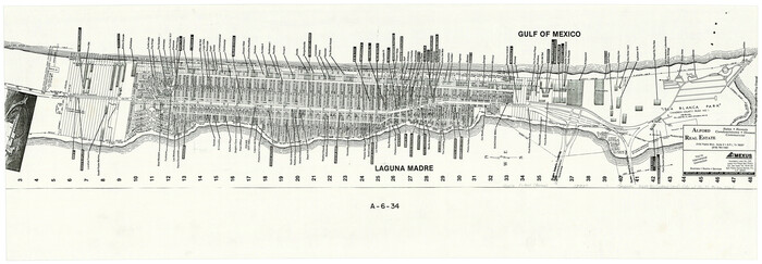
Cameron County Rolled Sketch 34

Print $20.00
- Digital $50.00
Cameron County Rolled Sketch 34
2000
Size: 24.2 x 35.2 inches
5397
Cameron County Sketch File 15

Print $26.00
- Digital $50.00
Cameron County Sketch File 15
1999
Size: 11.2 x 8.7 inches
17320
Cameron County Sketch File 16

Print $18.00
- Digital $50.00
Cameron County Sketch File 16
1998
Size: 11.2 x 8.6 inches
76334
Cameron County State Real Property Sketch 1

Print $20.00
- Digital $50.00
Cameron County State Real Property Sketch 1
1996
Size: 25.1 x 38.9 inches
80130
Cameron County State Real Property Sketch 2

Print $20.00
- Digital $50.00
Cameron County State Real Property Sketch 2
1996
Size: 25.4 x 39.1 inches
80132
Cameron County Rolled Sketch 33

Print $20.00
- Digital $50.00
Cameron County Rolled Sketch 33
1996
Size: 40.2 x 21.9 inches
5396
Cameron County Rolled Sketch 31

Print $20.00
- Digital $50.00
Cameron County Rolled Sketch 31
1993
Size: 18.4 x 24.3 inches
5395
Cameron County Sketch File 14

Print $38.00
- Digital $50.00
Cameron County Sketch File 14
1993
Size: 11.2 x 8.8 inches
17311
[Map of the City of South Padre Island]
Print $20.00
- Digital $50.00
[Map of the City of South Padre Island]
1993
Size: 12.5 x 36.5 inches
3212
Southern Part of Laguna Madre

Print $20.00
- Digital $50.00
Southern Part of Laguna Madre
1992
Size: 44.9 x 35.0 inches
73549
Cameron County Sketch File 11

Print $58.00
- Digital $50.00
Cameron County Sketch File 11
1991
Size: 11.0 x 7.9 inches
17207
Cameron County Rolled Sketch 29

Print $20.00
- Digital $50.00
Cameron County Rolled Sketch 29
1990
Size: 29.3 x 46.4 inches
8578
Brazos Island Harbor, Texas - Dredging Entrance Channel Plan

Print $20.00
- Digital $50.00
Brazos Island Harbor, Texas - Dredging Entrance Channel Plan
1990
Size: 14.6 x 20.0 inches
83337
Brazos Island Harbor, Texas - Dredging Entrance Channel Plan

Print $20.00
- Digital $50.00
Brazos Island Harbor, Texas - Dredging Entrance Channel Plan
1990
Size: 14.5 x 20.1 inches
83338
Brazos Island Harbor, Texas - Dredging Entrance Channel Plan

Print $20.00
- Digital $50.00
Brazos Island Harbor, Texas - Dredging Entrance Channel Plan
1990
Size: 14.5 x 19.9 inches
83339
Cameron County Sketch File 10

Print $8.00
- Digital $50.00
Cameron County Sketch File 10
1989
Size: 11.1 x 8.6 inches
17205
Southern Part of Laguna Madre

Print $20.00
- Digital $50.00
Southern Part of Laguna Madre
1987
Size: 44.5 x 34.7 inches
73548
Cameron County Rolled Sketch 28

Print $40.00
- Digital $50.00
Cameron County Rolled Sketch 28
1986
Size: 36.5 x 48.3 inches
8575
Cameron County Rolled Sketch 28A

Print $20.00
- Digital $50.00
Cameron County Rolled Sketch 28A
1986
Size: 36.0 x 47.6 inches
8576
Cameron County Rolled Sketch 28B

Print $40.00
- Digital $50.00
Cameron County Rolled Sketch 28B
1986
Size: 36.9 x 48.3 inches
8577
Southern Part of Laguna Madre

Print $20.00
- Digital $50.00
Southern Part of Laguna Madre
1985
Size: 45.3 x 36.6 inches
73547
Cameron County Sketch File 9

Print $26.00
- Digital $50.00
Cameron County Sketch File 9
1983
Size: 11.2 x 8.3 inches
17197
Hidalgo County Sketch File 19

Print $42.00
- Digital $50.00
Hidalgo County Sketch File 19
1983
Size: 11.3 x 8.9 inches
26448
Cameron County NRC Article 33.136 Sketch 5
Print $202.00
- Digital $50.00
Cameron County NRC Article 33.136 Sketch 5
2018
-
Size
24.3 x 36.1 inches
-
Map/Doc
95724
-
Creation Date
2018
Cameron County Sketch File 17
Print $24.00
- Digital $50.00
Cameron County Sketch File 17
2009
-
Size
11.0 x 8.5 inches
-
Map/Doc
95191
-
Creation Date
2009
Land grants from the state of Tamaulipas in the trans-Nueces
Land grants from the state of Tamaulipas in the trans-Nueces
2009
-
Size
11.0 x 8.5 inches
-
Map/Doc
94040
-
Creation Date
2009
Cameron County NRC Article 33.136 Sketch 4
Print $94.00
- Digital $50.00
Cameron County NRC Article 33.136 Sketch 4
2007
-
Size
22.3 x 34.0 inches
-
Map/Doc
88721
-
Creation Date
2007
Cameron County NRC Article 33.136 Sketch 3
Print $7.00
- Digital $50.00
Cameron County NRC Article 33.136 Sketch 3
2003
-
Size
11.2 x 17.3 inches
-
Map/Doc
78540
-
Creation Date
2003
Cameron County NRC Article 33.136 Sketch 2
Print $20.00
- Digital $50.00
Cameron County NRC Article 33.136 Sketch 2
2002
-
Size
24.4 x 35.9 inches
-
Map/Doc
77040
-
Creation Date
2002
Cameron County NRC Article 33.136 Sketch 1
Print $3.00
- Digital $50.00
Cameron County NRC Article 33.136 Sketch 1
2001
-
Size
11.3 x 17.4 inches
-
Map/Doc
61558
-
Creation Date
2001
Cameron County Rolled Sketch 34
Print $20.00
- Digital $50.00
Cameron County Rolled Sketch 34
2000
-
Size
24.2 x 35.2 inches
-
Map/Doc
5397
-
Creation Date
2000
Cameron County Sketch File 15
Print $26.00
- Digital $50.00
Cameron County Sketch File 15
1999
-
Size
11.2 x 8.7 inches
-
Map/Doc
17320
-
Creation Date
1999
Cameron County Sketch File 16
Print $18.00
- Digital $50.00
Cameron County Sketch File 16
1998
-
Size
11.2 x 8.6 inches
-
Map/Doc
76334
-
Creation Date
1998
Cameron County State Real Property Sketch 1
Print $20.00
- Digital $50.00
Cameron County State Real Property Sketch 1
1996
-
Size
25.1 x 38.9 inches
-
Map/Doc
80130
-
Creation Date
1996
Cameron County State Real Property Sketch 2
Print $20.00
- Digital $50.00
Cameron County State Real Property Sketch 2
1996
-
Size
25.4 x 39.1 inches
-
Map/Doc
80132
-
Creation Date
1996
Cameron County Rolled Sketch 33
Print $20.00
- Digital $50.00
Cameron County Rolled Sketch 33
1996
-
Size
40.2 x 21.9 inches
-
Map/Doc
5396
-
Creation Date
1996
Cameron County Rolled Sketch 31
Print $20.00
- Digital $50.00
Cameron County Rolled Sketch 31
1993
-
Size
18.4 x 24.3 inches
-
Map/Doc
5395
-
Creation Date
1993
Cameron County Sketch File 14
Print $38.00
- Digital $50.00
Cameron County Sketch File 14
1993
-
Size
11.2 x 8.8 inches
-
Map/Doc
17311
-
Creation Date
1993
[Map of the City of South Padre Island]
Print $20.00
- Digital $50.00
[Map of the City of South Padre Island]
1993
-
Size
12.5 x 36.5 inches
-
Map/Doc
3212
-
Creation Date
1993
Southern Part of Laguna Madre
Print $20.00
- Digital $50.00
Southern Part of Laguna Madre
1992
-
Size
44.9 x 35.0 inches
-
Map/Doc
73549
-
Creation Date
1992
Cameron County Sketch File 11
Print $58.00
- Digital $50.00
Cameron County Sketch File 11
1991
-
Size
11.0 x 7.9 inches
-
Map/Doc
17207
-
Creation Date
1991
Cameron County Rolled Sketch 29
Print $20.00
- Digital $50.00
Cameron County Rolled Sketch 29
1990
-
Size
29.3 x 46.4 inches
-
Map/Doc
8578
-
Creation Date
1990
Brazos Island Harbor, Texas - Dredging Entrance Channel Plan
Print $20.00
- Digital $50.00
Brazos Island Harbor, Texas - Dredging Entrance Channel Plan
1990
-
Size
14.6 x 20.0 inches
-
Map/Doc
83337
-
Creation Date
1990
Brazos Island Harbor, Texas - Dredging Entrance Channel Plan
Print $20.00
- Digital $50.00
Brazos Island Harbor, Texas - Dredging Entrance Channel Plan
1990
-
Size
14.5 x 20.1 inches
-
Map/Doc
83338
-
Creation Date
1990
Brazos Island Harbor, Texas - Dredging Entrance Channel Plan
Print $20.00
- Digital $50.00
Brazos Island Harbor, Texas - Dredging Entrance Channel Plan
1990
-
Size
14.5 x 19.9 inches
-
Map/Doc
83339
-
Creation Date
1990
Cameron County Sketch File 10
Print $8.00
- Digital $50.00
Cameron County Sketch File 10
1989
-
Size
11.1 x 8.6 inches
-
Map/Doc
17205
-
Creation Date
1989
Southern Part of Laguna Madre
Print $20.00
- Digital $50.00
Southern Part of Laguna Madre
1987
-
Size
44.5 x 34.7 inches
-
Map/Doc
73548
-
Creation Date
1987
Cameron County Rolled Sketch 28
Print $40.00
- Digital $50.00
Cameron County Rolled Sketch 28
1986
-
Size
36.5 x 48.3 inches
-
Map/Doc
8575
-
Creation Date
1986
Cameron County Rolled Sketch 28A
Print $20.00
- Digital $50.00
Cameron County Rolled Sketch 28A
1986
-
Size
36.0 x 47.6 inches
-
Map/Doc
8576
-
Creation Date
1986
Cameron County Rolled Sketch 28B
Print $40.00
- Digital $50.00
Cameron County Rolled Sketch 28B
1986
-
Size
36.9 x 48.3 inches
-
Map/Doc
8577
-
Creation Date
1986
Southern Part of Laguna Madre
Print $20.00
- Digital $50.00
Southern Part of Laguna Madre
1985
-
Size
45.3 x 36.6 inches
-
Map/Doc
73547
-
Creation Date
1985
Cameron County Sketch File 9
Print $26.00
- Digital $50.00
Cameron County Sketch File 9
1983
-
Size
11.2 x 8.3 inches
-
Map/Doc
17197
-
Creation Date
1983
Hidalgo County Sketch File 19
Print $42.00
- Digital $50.00
Hidalgo County Sketch File 19
1983
-
Size
11.3 x 8.9 inches
-
Map/Doc
26448
-
Creation Date
1983