Cameron County State Real Property Sketch 2
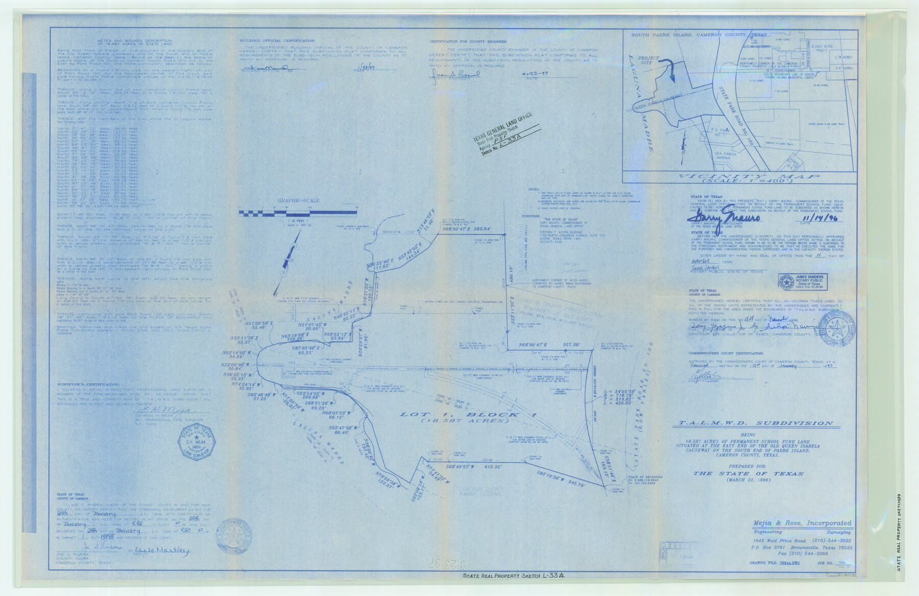
T. A. L. M. W. D. Subdivision Being 18.587 Acres of Permanent School Fund Land Situated at the East End of the Old Queen Isabela Causeway on the South End of Padre Island
State Real Property Sketch L - 33
-
Map/Doc
80132
-
Collection
General Map Collection
-
Object Dates
1996/3/22 (Creation Date)
-
People and Organizations
Mejia and Rose, Incorporated (Publisher)
Mejia and Rose, Incorporated (Printer)
Garry Mauro (GLO Commissioner)
Eduardo H. Mejia (Surveyor/Engineer)
-
Counties
Cameron
-
Subjects
State Real Property
-
Height x Width
25.4 x 39.1 inches
64.5 x 99.3 cm
-
Comments
Surveys located about 22 and 1/2 miles North 60 degrees East of Brownsville, Texas.
Part of: General Map Collection
Plan of Calhoun

Print $20.00
- Digital $50.00
Plan of Calhoun
1839
Size 18.6 x 22.7 inches
Map/Doc 176
Montgomery County Sketch File 9

Print $6.00
- Digital $50.00
Montgomery County Sketch File 9
Size 9.0 x 7.6 inches
Map/Doc 31795
Johnson County

Print $20.00
- Digital $50.00
Johnson County
1859
Size 22.0 x 29.6 inches
Map/Doc 3732
Flight Mission No. DQN-2K, Frame 76, Calhoun County

Print $20.00
- Digital $50.00
Flight Mission No. DQN-2K, Frame 76, Calhoun County
1953
Size 18.8 x 22.3 inches
Map/Doc 84268
McCulloch County Working Sketch 9

Print $20.00
- Digital $50.00
McCulloch County Working Sketch 9
1978
Size 35.6 x 32.7 inches
Map/Doc 70684
Wichita County Sketch File H

Print $4.00
- Digital $50.00
Wichita County Sketch File H
1884
Size 12.8 x 8.2 inches
Map/Doc 40089
Flight Mission No. DAG-21K, Frame 31, Matagorda County

Print $20.00
- Digital $50.00
Flight Mission No. DAG-21K, Frame 31, Matagorda County
1952
Size 18.7 x 22.4 inches
Map/Doc 86398
Hardin County Working Sketch 31

Print $20.00
- Digital $50.00
Hardin County Working Sketch 31
1971
Size 43.0 x 33.2 inches
Map/Doc 63429
La Salle County Rolled Sketch 6

Print $40.00
- Digital $50.00
La Salle County Rolled Sketch 6
1941
Size 43.0 x 66.0 inches
Map/Doc 10738
Tom Green County Sketch File 16

Print $16.00
- Digital $50.00
Tom Green County Sketch File 16
Size 8.5 x 7.8 inches
Map/Doc 38174
Hutchinson County Working Sketch 46

Print $20.00
- Digital $50.00
Hutchinson County Working Sketch 46
1979
Size 20.4 x 22.3 inches
Map/Doc 66406
Oldham County Boundary File 2

Print $10.00
- Digital $50.00
Oldham County Boundary File 2
Size 14.2 x 8.6 inches
Map/Doc 57766
You may also like
Pecos County Rolled Sketch 53

Print $20.00
- Digital $50.00
Pecos County Rolled Sketch 53
1915
Size 26.2 x 38.5 inches
Map/Doc 7228
Rusk County Working Sketch 36

Print $20.00
- Digital $50.00
Rusk County Working Sketch 36
2007
Size 31.7 x 36.0 inches
Map/Doc 83786
Duval County Sketch File 69

Print $20.00
- Digital $50.00
Duval County Sketch File 69
1951
Size 30.2 x 13.3 inches
Map/Doc 11408
Madison County Working Sketch 13

Print $20.00
- Digital $50.00
Madison County Working Sketch 13
1995
Size 15.5 x 22.9 inches
Map/Doc 70775
Dallas County Sketch File 15

Print $10.00
- Digital $50.00
Dallas County Sketch File 15
1863
Size 11.5 x 8.5 inches
Map/Doc 20430
Kinney County Working Sketch 22

Print $20.00
- Digital $50.00
Kinney County Working Sketch 22
1950
Size 46.5 x 37.2 inches
Map/Doc 70204
San Jacinto County Rolled Sketch 12

Print $20.00
- Digital $50.00
San Jacinto County Rolled Sketch 12
1948
Size 24.2 x 32.5 inches
Map/Doc 7561
Flight Mission No. DAG-24K, Frame 131, Matagorda County

Print $20.00
- Digital $50.00
Flight Mission No. DAG-24K, Frame 131, Matagorda County
1953
Size 18.6 x 22.4 inches
Map/Doc 86549
Oldham County

Print $40.00
- Digital $50.00
Oldham County
1925
Size 42.6 x 51.5 inches
Map/Doc 77387
Dickens County Boundary File 3

Print $28.00
- Digital $50.00
Dickens County Boundary File 3
Size 14.1 x 8.8 inches
Map/Doc 52541
Intracoastal Waterway, Houma, LA to Corpus Christi, TX

Print $5.00
- Digital $50.00
Intracoastal Waterway, Houma, LA to Corpus Christi, TX
Size 22.3 x 28.0 inches
Map/Doc 61914
[Sketch Showing Blocks in Hansford County, Texas]
![75819, [Sketch Showing Blocks in Hansford County, Texas], Maddox Collection](https://historictexasmaps.com/wmedia_w700/maps/75819.tif.jpg)
Print $20.00
- Digital $50.00
[Sketch Showing Blocks in Hansford County, Texas]
1890
Size 34.1 x 25.3 inches
Map/Doc 75819