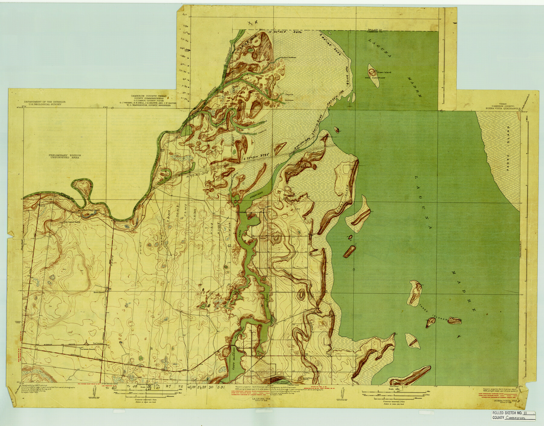
Cameron County Rolled Sketch 11
Buena Vista Quadrangle [with manuscript annotations]
-
Map/Doc
11047
-
Collection
General Map Collection
-
Object Dates
1937/10/13 (File Date)
1935 (Edition Date)
-
People and Organizations
United States Geological Survey (Publisher)
-
Counties
Cameron
-
Subjects
Surveying Rolled Sketch
-
Height x Width
26.7 x 34.0 inches
67.8 x 86.4 cm
-
Medium
paper, etching/engraving/lithograph
-
Comments
See SF-13832
Part of: General Map Collection
Pecos County Sketch File 48

Print $4.00
- Digital $50.00
Pecos County Sketch File 48
1935
Size 14.3 x 8.8 inches
Map/Doc 33762
Yoakum County Rolled Sketch 7

Print $20.00
- Digital $50.00
Yoakum County Rolled Sketch 7
2012
Size 25.9 x 18.7 inches
Map/Doc 93291
Flight Mission No. DIX-6P, Frame 126, Aransas County

Print $20.00
- Digital $50.00
Flight Mission No. DIX-6P, Frame 126, Aransas County
1956
Size 19.3 x 22.9 inches
Map/Doc 83832
Outer Continental Shelf Leasing Maps (Louisiana Offshore Operations)

Print $20.00
- Digital $50.00
Outer Continental Shelf Leasing Maps (Louisiana Offshore Operations)
1954
Size 22.2 x 12.0 inches
Map/Doc 76096
Culberson County Working Sketch 21

Print $40.00
- Digital $50.00
Culberson County Working Sketch 21
1936
Size 36.7 x 57.8 inches
Map/Doc 68473
Haskell County Working Sketch 10

Print $20.00
- Digital $50.00
Haskell County Working Sketch 10
1961
Size 26.8 x 20.4 inches
Map/Doc 66068
Flight Mission No. CGI-3N, Frame 120, Cameron County

Print $20.00
- Digital $50.00
Flight Mission No. CGI-3N, Frame 120, Cameron County
1954
Size 18.8 x 22.3 inches
Map/Doc 84593
Crockett County Rolled Sketch 27

Print $20.00
- Digital $50.00
Crockett County Rolled Sketch 27
1925
Size 20.8 x 38.0 inches
Map/Doc 5586
Intracoastal Waterway in Texas - Corpus Christi to Point Isabel including Arroyo Colorado to Mo. Pac. R.R. Bridge Near Harlingen

Print $20.00
- Digital $50.00
Intracoastal Waterway in Texas - Corpus Christi to Point Isabel including Arroyo Colorado to Mo. Pac. R.R. Bridge Near Harlingen
1934
Size 21.5 x 32.4 inches
Map/Doc 61883
Brewster County Sketch File NS-3

Print $40.00
- Digital $50.00
Brewster County Sketch File NS-3
1913
Size 30.9 x 15.6 inches
Map/Doc 10986
Roberts County Working Sketch 33

Print $20.00
- Digital $50.00
Roberts County Working Sketch 33
1978
Size 26.6 x 22.4 inches
Map/Doc 63559
Kent County Sketch File 7

Print $20.00
- Digital $50.00
Kent County Sketch File 7
1902
Size 21.7 x 37.6 inches
Map/Doc 10514
You may also like
Yoakum County Sketch File 5

Print $10.00
- Digital $50.00
Yoakum County Sketch File 5
1899
Size 14.3 x 9.0 inches
Map/Doc 40733
Ward County Rolled Sketch 26

Print $28.00
- Digital $50.00
Ward County Rolled Sketch 26
Size 9.9 x 15.0 inches
Map/Doc 49468
Bosque County

Print $40.00
- Digital $50.00
Bosque County
1945
Size 48.8 x 38.7 inches
Map/Doc 95432
Map of Bell County

Print $40.00
- Digital $50.00
Map of Bell County
1896
Size 46.7 x 53.7 inches
Map/Doc 4884
Kent County Sketch File 11

Print $22.00
- Digital $50.00
Kent County Sketch File 11
1915
Size 7.9 x 8.6 inches
Map/Doc 28838
Johnson County Boundary File 51c

Print $18.00
- Digital $50.00
Johnson County Boundary File 51c
Size 8.2 x 5.2 inches
Map/Doc 55622
Harris County Rolled Sketch 84

Print $20.00
- Digital $50.00
Harris County Rolled Sketch 84
1957
Size 38.7 x 31.7 inches
Map/Doc 6118
Blanco County Rolled Sketch 23

Print $20.00
- Digital $50.00
Blanco County Rolled Sketch 23
2019
Size 24.1 x 35.7 inches
Map/Doc 97346
Rio Grande, Hargill Sheet

Print $20.00
- Digital $50.00
Rio Grande, Hargill Sheet
1937
Size 37.3 x 37.8 inches
Map/Doc 65109
[Capitol Lands in Oldham and Deaf Smith Counties]
![91482, [Capitol Lands in Oldham and Deaf Smith Counties], Twichell Survey Records](https://historictexasmaps.com/wmedia_w700/maps/91482-1.tif.jpg)
Print $20.00
- Digital $50.00
[Capitol Lands in Oldham and Deaf Smith Counties]
Size 23.2 x 25.8 inches
Map/Doc 91482
Childress County Sketch File 15

Print $8.00
- Digital $50.00
Childress County Sketch File 15
Size 14.3 x 8.3 inches
Map/Doc 18278
Dickens County Sketch File H2

Print $2.00
- Digital $50.00
Dickens County Sketch File H2
Size 12.9 x 8.2 inches
Map/Doc 20874