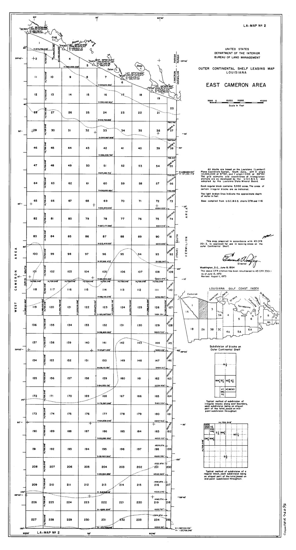
Outer Continental Shelf Leasing Maps (Louisiana Offshore Operations)
D-7-3; D-7-4
-
Map/Doc
76096
-
Collection
General Map Collection
-
Object Dates
1954/6/8 (Creation Date)
1973/8/1 (Revision Date)
-
Subjects
Energy Offshore Submerged Area
-
Height x Width
22.2 x 12.0 inches
56.4 x 30.5 cm
Part of: General Map Collection
Cooke County Sketch File 14

Print $4.00
- Digital $50.00
Cooke County Sketch File 14
Size 10.3 x 8.2 inches
Map/Doc 19248
Kimble County Working Sketch 87

Print $20.00
- Digital $50.00
Kimble County Working Sketch 87
1974
Size 24.1 x 30.0 inches
Map/Doc 70155
Eastland County Sketch File 8

Print $8.00
- Digital $50.00
Eastland County Sketch File 8
1872
Size 12.9 x 8.1 inches
Map/Doc 21576
Flight Mission No. CGI-4N, Frame 26, Cameron County

Print $20.00
- Digital $50.00
Flight Mission No. CGI-4N, Frame 26, Cameron County
1954
Size 18.8 x 22.3 inches
Map/Doc 84659
Starr County Rolled Sketch 11

Print $20.00
- Digital $50.00
Starr County Rolled Sketch 11
1912
Size 16.5 x 16.4 inches
Map/Doc 7798
Crane County Working Sketch 23

Print $20.00
- Digital $50.00
Crane County Working Sketch 23
1963
Size 25.8 x 23.2 inches
Map/Doc 68300
Flight Mission No. CGI-4N, Frame 158, Cameron County

Print $20.00
- Digital $50.00
Flight Mission No. CGI-4N, Frame 158, Cameron County
1955
Size 18.5 x 22.2 inches
Map/Doc 84666
Presidio County Rolled Sketch 33

Print $40.00
- Digital $50.00
Presidio County Rolled Sketch 33
Size 57.7 x 42.3 inches
Map/Doc 9772
Tom Green County

Print $20.00
- Digital $50.00
Tom Green County
1942
Size 43.5 x 24.8 inches
Map/Doc 77437
[Affadavit regarding boundary lines between the several coastal counties from coastline to Continental Shelf]
![2089, [Affadavit regarding boundary lines between the several coastal counties from coastline to Continental Shelf], General Map Collection](https://historictexasmaps.com/wmedia_w700/maps/2089-1.tif.jpg)
Print $20.00
- Digital $50.00
[Affadavit regarding boundary lines between the several coastal counties from coastline to Continental Shelf]
1947
Size 18.1 x 12.7 inches
Map/Doc 2089
Clay County Working Sketch 10

Print $20.00
- Digital $50.00
Clay County Working Sketch 10
1941
Size 35.5 x 26.5 inches
Map/Doc 68033
Gregg County Rolled Sketch 20

Print $20.00
- Digital $50.00
Gregg County Rolled Sketch 20
1957
Size 34.0 x 44.4 inches
Map/Doc 9070
You may also like
Gillespie County

Print $40.00
- Digital $50.00
Gillespie County
1887
Size 38.9 x 49.8 inches
Map/Doc 4956
Fort Bend County Rolled Sketch 1

Print $20.00
- Digital $50.00
Fort Bend County Rolled Sketch 1
Size 24.3 x 27.5 inches
Map/Doc 5891
Trinity River, Grapevine Sheet/Denton Creek

Print $6.00
- Digital $50.00
Trinity River, Grapevine Sheet/Denton Creek
1938
Size 22.2 x 34.7 inches
Map/Doc 65243
Donley County Sketch File B6

Print $20.00
- Digital $50.00
Donley County Sketch File B6
1919
Size 16.5 x 14.6 inches
Map/Doc 11376
El Paso County Boundary File 12

Print $16.00
- Digital $50.00
El Paso County Boundary File 12
Size 13.9 x 8.5 inches
Map/Doc 53153
Howard County Sketch File 16

Print $40.00
- Digital $50.00
Howard County Sketch File 16
1947
Size 19.7 x 9.0 inches
Map/Doc 26878
Dimmit County Rolled Sketch 22

Print $20.00
- Digital $50.00
Dimmit County Rolled Sketch 22
2012
Size 31.5 x 24.0 inches
Map/Doc 93629
Amistad International Reservoir on Rio Grande 80

Print $20.00
- Digital $50.00
Amistad International Reservoir on Rio Grande 80
1949
Size 28.4 x 40.2 inches
Map/Doc 75509
Flight Mission No. CUG-3P, Frame 168, Kleberg County

Print $20.00
- Digital $50.00
Flight Mission No. CUG-3P, Frame 168, Kleberg County
1956
Size 18.6 x 22.3 inches
Map/Doc 86288
General Highway Map, Lamb County, Texas

Print $20.00
General Highway Map, Lamb County, Texas
1940
Size 24.7 x 18.3 inches
Map/Doc 79168
Flight Mission No. DCL-7C, Frame 146, Kenedy County

Print $20.00
- Digital $50.00
Flight Mission No. DCL-7C, Frame 146, Kenedy County
1943
Size 18.8 x 22.4 inches
Map/Doc 86103
Map of Lockhart, Caldwell Co., Texas

Print $20.00
- Digital $50.00
Map of Lockhart, Caldwell Co., Texas
1907
Size 30.5 x 38.9 inches
Map/Doc 4461