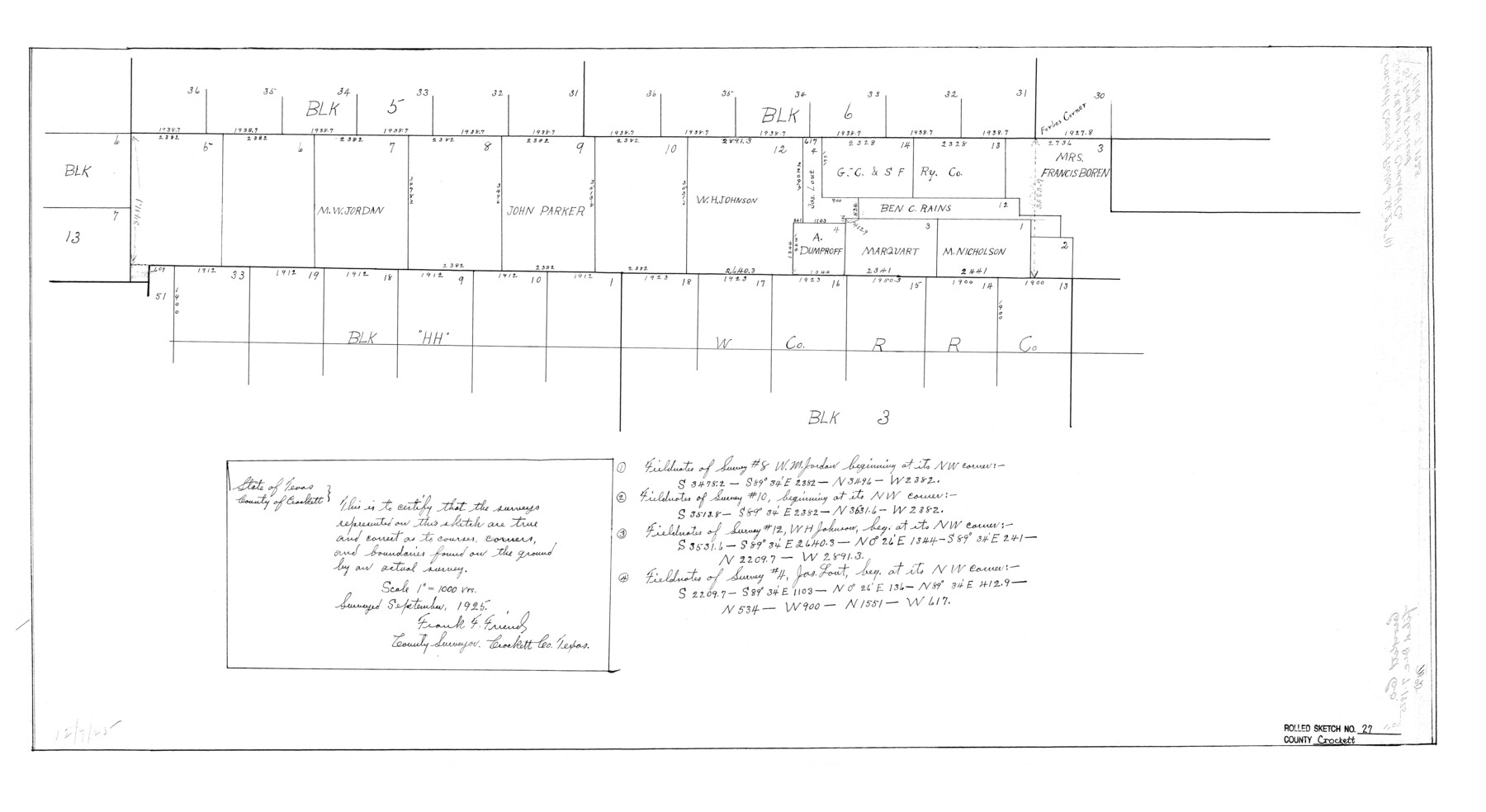
Crockett County Rolled Sketch 27
[Sketch in NW part of Crockett County, Texas showing north part of Blocks HH and 3 and strip surveys north thereof]
-
Map/Doc
5586
-
Collection
General Map Collection
-
Object Dates
1925 (Creation Date)
1925/12/7 (File Date)
-
People and Organizations
Frank F. Friend (Surveyor/Engineer)
-
Counties
Crockett
-
Subjects
Surveying Rolled Sketch
-
Height x Width
20.8 x 38.0 inches
52.8 x 96.5 cm
-
Scale
1" = 1000 varas
Part of: General Map Collection
Concho County Sketch File 3

Print $6.00
- Digital $50.00
Concho County Sketch File 3
1857
Size 13.1 x 8.4 inches
Map/Doc 19124
Starr County Rolled Sketch 10

Print $20.00
- Digital $50.00
Starr County Rolled Sketch 10
1912
Size 15.2 x 24.0 inches
Map/Doc 7797
Kinney County Working Sketch 23

Print $20.00
- Digital $50.00
Kinney County Working Sketch 23
1950
Size 20.8 x 24.3 inches
Map/Doc 70205
Orange County Working Sketch 31

Print $20.00
- Digital $50.00
Orange County Working Sketch 31
1955
Size 24.2 x 13.8 inches
Map/Doc 71363
Edwards County Sketch File 42

Print $20.00
- Digital $50.00
Edwards County Sketch File 42
1947
Size 17.9 x 22.7 inches
Map/Doc 11440
University Lands, Blocks 34 to 37, Terrell County

Print $20.00
- Digital $50.00
University Lands, Blocks 34 to 37, Terrell County
1938
Size 32.5 x 40.0 inches
Map/Doc 2417
Reagan County Working Sketch 41

Print $20.00
- Digital $50.00
Reagan County Working Sketch 41
1973
Size 28.6 x 38.9 inches
Map/Doc 71883
Scurry County Rolled Sketch 2A

Print $20.00
- Digital $50.00
Scurry County Rolled Sketch 2A
Size 25.6 x 24.2 inches
Map/Doc 7764
Duval County Boundary File 3h

Print $4.00
- Digital $50.00
Duval County Boundary File 3h
Size 10.0 x 8.0 inches
Map/Doc 52749
Clay County Rolled Sketch 1

Print $20.00
- Digital $50.00
Clay County Rolled Sketch 1
1940
Size 47.0 x 37.9 inches
Map/Doc 8621
Randall County

Print $20.00
- Digital $50.00
Randall County
1917
Size 44.7 x 36.9 inches
Map/Doc 16793
Dickens County Sketch File 1

Print $20.00
- Digital $50.00
Dickens County Sketch File 1
1879
Size 18.2 x 15.5 inches
Map/Doc 11315
You may also like
Falls County Sketch File 28

Print $2.00
- Digital $50.00
Falls County Sketch File 28
Size 7.7 x 10.3 inches
Map/Doc 22438
Newton County Working Sketch 42

Print $20.00
- Digital $50.00
Newton County Working Sketch 42
1981
Size 26.4 x 22.5 inches
Map/Doc 71288
Hockley County

Print $20.00
- Digital $50.00
Hockley County
1900
Size 41.5 x 36.7 inches
Map/Doc 16852
Working Sketch Crosby, Garza, Lynn, and Lubbock Counties

Print $20.00
- Digital $50.00
Working Sketch Crosby, Garza, Lynn, and Lubbock Counties
1904
Size 34.3 x 36.4 inches
Map/Doc 92695
Jeff Davis County Rolled Sketch 19

Print $40.00
- Digital $50.00
Jeff Davis County Rolled Sketch 19
1885
Size 37.1 x 57.9 inches
Map/Doc 9265
Nueces County Working Sketch 1

Print $20.00
- Digital $50.00
Nueces County Working Sketch 1
1937
Size 27.9 x 28.5 inches
Map/Doc 71303
Brown County Working Sketch 17

Print $20.00
- Digital $50.00
Brown County Working Sketch 17
1993
Size 25.6 x 29.4 inches
Map/Doc 67782
Geological Petroleum Corporation Map of North Central Texas

Print $20.00
Geological Petroleum Corporation Map of North Central Texas
1920
Size 37.4 x 28.4 inches
Map/Doc 79305
Johnson County Working Sketch 21

Print $20.00
- Digital $50.00
Johnson County Working Sketch 21
1995
Size 18.1 x 29.6 inches
Map/Doc 66634
[Sketch for Mineral Application 26543 - Sabine River, D. H. Sanford]
![65677, [Sketch for Mineral Application 26543 - Sabine River, D. H. Sanford], General Map Collection](https://historictexasmaps.com/wmedia_w700/maps/65677.tif.jpg)
Print $40.00
- Digital $50.00
[Sketch for Mineral Application 26543 - Sabine River, D. H. Sanford]
1931
Size 30.8 x 71.9 inches
Map/Doc 65677
Kimble County Rolled Sketch 23

Print $20.00
- Digital $50.00
Kimble County Rolled Sketch 23
Size 16.0 x 21.0 inches
Map/Doc 6513
![94197, New Mexico [Verso], General Map Collection](https://historictexasmaps.com/wmedia_w700/maps/94197.tif.jpg)