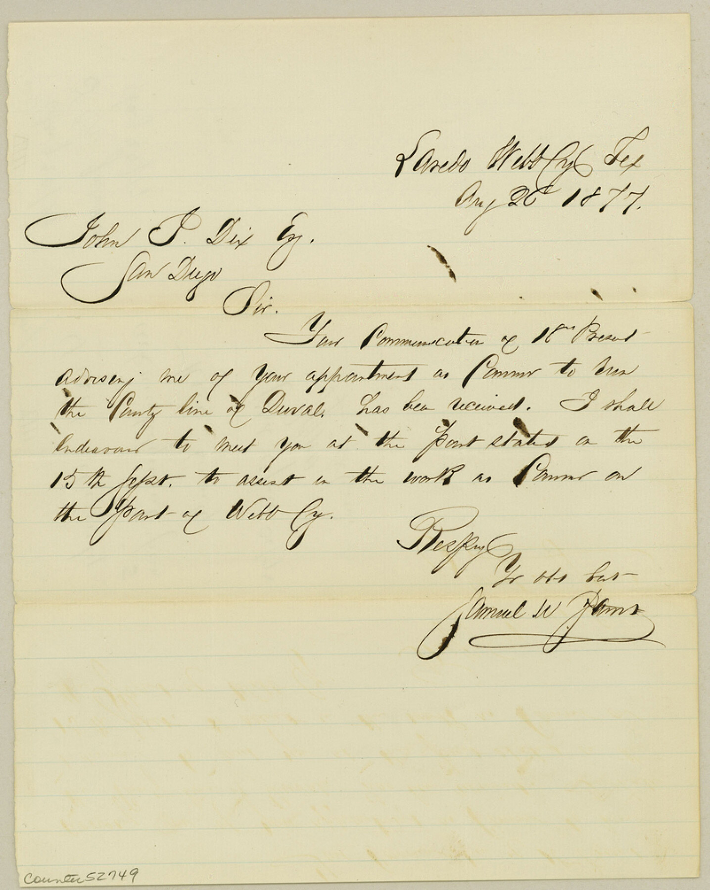
Duval County Boundary File 3h
Acknowledgment from Webb County
-
Map/Doc
52749
-
Collection
General Map Collection
-
Counties
Duval
-
Subjects
County Boundaries
-
Height x Width
10.0 x 8.0 inches
25.4 x 20.3 cm
Part of: General Map Collection
Garza County Sketch File 31

Print $10.00
- Digital $50.00
Garza County Sketch File 31
1914
Size 13.4 x 8.9 inches
Map/Doc 24104
Surveys made on La Parita, March 1847

Print $2.00
- Digital $50.00
Surveys made on La Parita, March 1847
1847
Size 10.1 x 7.5 inches
Map/Doc 222
Reyno de la Nueva Espana a Principios del Siglo XIX

Print $20.00
- Digital $50.00
Reyno de la Nueva Espana a Principios del Siglo XIX
Size 26.0 x 34.3 inches
Map/Doc 96807
Orange County Working Sketch 54b

Print $40.00
- Digital $50.00
Orange County Working Sketch 54b
2008
Size 38.0 x 50.3 inches
Map/Doc 88743
Pecos County Working Sketch 108

Print $40.00
- Digital $50.00
Pecos County Working Sketch 108
1971
Size 43.5 x 56.3 inches
Map/Doc 71581
Presidio County Rolled Sketch 80B

Print $20.00
- Digital $50.00
Presidio County Rolled Sketch 80B
1943
Size 17.4 x 18.3 inches
Map/Doc 2060
Pecos County Rolled Sketch 176

Print $20.00
- Digital $50.00
Pecos County Rolled Sketch 176
1978
Size 14.1 x 33.6 inches
Map/Doc 7296
Runnels County Working Sketch 30a

Print $20.00
- Digital $50.00
Runnels County Working Sketch 30a
1959
Size 23.3 x 25.4 inches
Map/Doc 63626
Aransas County Rolled Sketch 1

Print $40.00
- Digital $50.00
Aransas County Rolled Sketch 1
1930
Size 11.5 x 49.5 inches
Map/Doc 10685
Roberts County Working Sketch 8

Print $20.00
- Digital $50.00
Roberts County Working Sketch 8
1963
Size 21.9 x 26.0 inches
Map/Doc 63534
Liberty County Sketch File 14

Print $4.00
- Digital $50.00
Liberty County Sketch File 14
1858
Size 12.9 x 8.1 inches
Map/Doc 29915
Val Verde County Sketch File 42

Print $20.00
- Digital $50.00
Val Verde County Sketch File 42
1939
Size 19.4 x 20.3 inches
Map/Doc 12584
You may also like
Current Miscellaneous File 41

Print $8.00
- Digital $50.00
Current Miscellaneous File 41
Size 8.2 x 10.8 inches
Map/Doc 73977
[Lower Part of Milam District]
![1961, [Lower Part of Milam District], General Map Collection](https://historictexasmaps.com/wmedia_w700/maps/1961.tif.jpg)
Print $20.00
- Digital $50.00
[Lower Part of Milam District]
1850
Size 46.5 x 44.2 inches
Map/Doc 1961
Victoria County Boundary File 91

Print $12.00
- Digital $50.00
Victoria County Boundary File 91
Size 8.9 x 6.5 inches
Map/Doc 59620
[H. & G. N. Block 1 resurvey]
![90951, [H. & G. N. Block 1 resurvey], Twichell Survey Records](https://historictexasmaps.com/wmedia_w700/maps/90951-1.tif.jpg)
Print $20.00
- Digital $50.00
[H. & G. N. Block 1 resurvey]
1902
Size 14.7 x 17.2 inches
Map/Doc 90951
Lipscomb County Rolled Sketch 6

Print $20.00
- Digital $50.00
Lipscomb County Rolled Sketch 6
1941
Size 44.8 x 21.8 inches
Map/Doc 42260
Mexico und Centro-America

Print $20.00
Mexico und Centro-America
1841
Size 14.1 x 17.1 inches
Map/Doc 79732
Kerr County Boundary File 55

Print $64.00
- Digital $50.00
Kerr County Boundary File 55
Size 8.7 x 3.5 inches
Map/Doc 64826
Map of Cameron County

Print $40.00
- Digital $50.00
Map of Cameron County
1895
Size 48.9 x 28.9 inches
Map/Doc 4901

Bosque County Sketch File 9

Print $6.00
- Digital $50.00
Bosque County Sketch File 9
1859
Size 4.3 x 4.7 inches
Map/Doc 14754
General Highway Map, Kerr County, Texas

Print $20.00
General Highway Map, Kerr County, Texas
1961
Size 24.6 x 18.2 inches
Map/Doc 79552
Flight Mission No. CRK-5P, Frame 125, Refugio County

Print $20.00
- Digital $50.00
Flight Mission No. CRK-5P, Frame 125, Refugio County
1956
Size 18.3 x 22.3 inches
Map/Doc 86928