Calhoun County Rolled Sketch 14
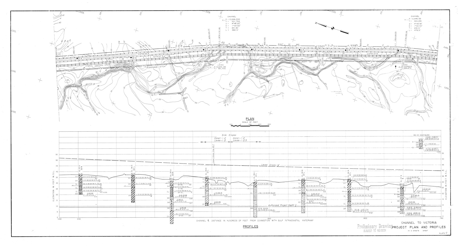
Channel to Victoria - Project plan and profiles in 10 sheets [Sheet 9]
-
Map/Doc
5461
-
Collection
General Map Collection
-
Counties
Calhoun
-
Subjects
Surveying Rolled Sketch
-
Height x Width
21.5 x 40.2 inches
54.6 x 102.1 cm
-
Medium
blueprint/diazo
-
Comments
See Calhoun County Sketch File 16 (35982) for correspondence.
Related maps
Calhoun County Sketch File 16

Print $4.00
- Digital $50.00
Calhoun County Sketch File 16
1954
Size 10.7 x 8.3 inches
Map/Doc 35982
Part of: General Map Collection
San Saba County Sketch File 10

Print $20.00
- Digital $50.00
San Saba County Sketch File 10
1883
Size 20.4 x 16.5 inches
Map/Doc 12290
Reagan County Sketch File 22

Print $6.00
- Digital $50.00
Reagan County Sketch File 22
1939
Size 11.4 x 8.9 inches
Map/Doc 35013
Willacy County

Print $20.00
- Digital $50.00
Willacy County
1921
Size 25.2 x 33.1 inches
Map/Doc 1901
Henderson County Sketch File 9

Print $8.00
- Digital $50.00
Henderson County Sketch File 9
Size 8.3 x 7.8 inches
Map/Doc 26343
Frio County Working Sketch 28

Print $20.00
- Digital $50.00
Frio County Working Sketch 28
2006
Size 40.8 x 42.0 inches
Map/Doc 83605


Flight Mission No. CGI-1N, Frame 183, Cameron County

Print $20.00
- Digital $50.00
Flight Mission No. CGI-1N, Frame 183, Cameron County
1955
Size 18.8 x 22.2 inches
Map/Doc 84518

Swisher County Sketch File 3

Print $20.00
- Digital $50.00
Swisher County Sketch File 3
1896
Size 17.2 x 16.1 inches
Map/Doc 12403
Webb County Sketch File 60

Print $8.00
- Digital $50.00
Webb County Sketch File 60
1943
Size 14.4 x 8.9 inches
Map/Doc 39855
You may also like
Fractional Township No. 8 South Range No. 23 East of the Indian Meridian, Indian Territory

Print $20.00
- Digital $50.00
Fractional Township No. 8 South Range No. 23 East of the Indian Meridian, Indian Territory
1898
Size 19.1 x 24.3 inches
Map/Doc 75249
Brewster County Rolled Sketch 18A

Print $20.00
- Digital $50.00
Brewster County Rolled Sketch 18A
1906
Size 18.6 x 17.2 inches
Map/Doc 5196
San Antonio & Surrounding Area

San Antonio & Surrounding Area
1997
Size 36.4 x 46.3 inches
Map/Doc 96867
Walker County Sketch File 4

Print $4.00
- Digital $50.00
Walker County Sketch File 4
Size 7.8 x 7.3 inches
Map/Doc 39553
Flight Mission No. DCL-7C, Frame 145, Kenedy County

Print $20.00
- Digital $50.00
Flight Mission No. DCL-7C, Frame 145, Kenedy County
1943
Size 18.6 x 22.5 inches
Map/Doc 86102
Flight Mission No. CGI-3N, Frame 163, Cameron County

Print $20.00
- Digital $50.00
Flight Mission No. CGI-3N, Frame 163, Cameron County
1954
Size 18.5 x 22.3 inches
Map/Doc 84627
Coryell County Sketch File 15

Print $4.00
- Digital $50.00
Coryell County Sketch File 15
1873
Size 13.0 x 8.5 inches
Map/Doc 19371
Carta Orografica

Print $20.00
- Digital $50.00
Carta Orografica
Size 26.0 x 34.4 inches
Map/Doc 96802

Flight Mission No. DAG-21K, Frame 86, Matagorda County

Print $20.00
- Digital $50.00
Flight Mission No. DAG-21K, Frame 86, Matagorda County
1952
Size 18.5 x 19.5 inches
Map/Doc 86415
Galveston Bay

Print $20.00
- Digital $50.00
Galveston Bay
1907
Size 40.6 x 34.4 inches
Map/Doc 69871
Kimble County

Print $40.00
- Digital $50.00
Kimble County
1930
Size 44.8 x 50.3 inches
Map/Doc 95557