Angelina County Sketch File 11e
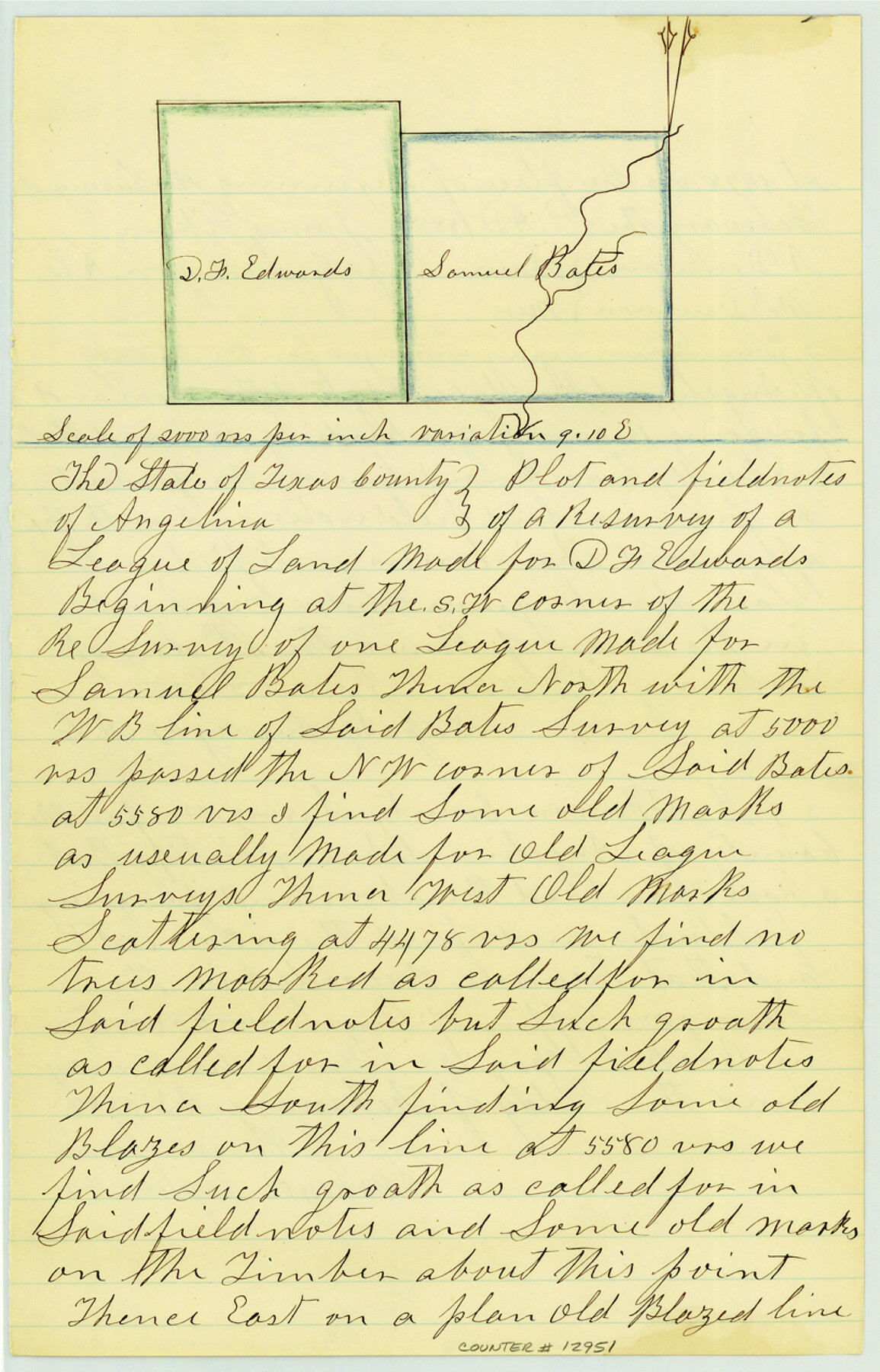
[Plat and field notes of a resurvey of a league of land made for D.F. Edwards on waters of Shawnee Creek]
-
Map/Doc
12951
-
Collection
General Map Collection
-
Object Dates
1885/2/5 (Creation Date)
-
People and Organizations
James Gibson (Surveyor/Engineer)
A. Denman (Chainman)
M. Denman (Chainman)
-
Counties
Angelina
-
Subjects
Surveying Sketch File
-
Height x Width
12.7 x 8.2 inches
32.3 x 20.8 cm
-
Medium
paper, manuscript
-
Features
[Shawnee Creek]
Part of: General Map Collection
Hall County Rolled Sketch 8

Print $20.00
- Digital $50.00
Hall County Rolled Sketch 8
1942
Size 24.7 x 41.6 inches
Map/Doc 6052
Nueces County Sketch File 59

Print $23.00
- Digital $50.00
Nueces County Sketch File 59
1989
Size 11.2 x 8.6 inches
Map/Doc 32951
Goliad County Sketch File 10

Print $4.00
- Digital $50.00
Goliad County Sketch File 10
1859
Size 9.3 x 8.1 inches
Map/Doc 24226
Harris County Working Sketch 1

Print $20.00
- Digital $50.00
Harris County Working Sketch 1
Size 15.8 x 15.8 inches
Map/Doc 65893
Real County Working Sketch 20

Print $20.00
- Digital $50.00
Real County Working Sketch 20
1944
Size 19.0 x 24.9 inches
Map/Doc 71912
Flight Mission No. CGI-4N, Frame 165, Cameron County

Print $20.00
- Digital $50.00
Flight Mission No. CGI-4N, Frame 165, Cameron County
1955
Size 18.4 x 22.3 inches
Map/Doc 84673
Fractional Township No. 10 South Range No. 26 East of the Indian Meridian, Indian Territory

Print $20.00
- Digital $50.00
Fractional Township No. 10 South Range No. 26 East of the Indian Meridian, Indian Territory
1897
Size 19.2 x 24.3 inches
Map/Doc 75245
Brazos Santiago, Texas

Print $20.00
- Digital $50.00
Brazos Santiago, Texas
1900
Size 18.3 x 26.7 inches
Map/Doc 73032
Midland County Working Sketch 4

Print $20.00
- Digital $50.00
Midland County Working Sketch 4
Size 20.3 x 44.3 inches
Map/Doc 70984
Newton County Working Sketch 45

Print $20.00
- Digital $50.00
Newton County Working Sketch 45
1996
Size 16.4 x 24.0 inches
Map/Doc 71291
Edwards County Working Sketch 137

Print $20.00
- Digital $50.00
Edwards County Working Sketch 137
1997
Size 33.2 x 34.3 inches
Map/Doc 69013
Flight Mission No. BRA-16M, Frame 101, Jefferson County

Print $20.00
- Digital $50.00
Flight Mission No. BRA-16M, Frame 101, Jefferson County
1953
Size 18.6 x 22.4 inches
Map/Doc 85713
You may also like
Coryell County Sketch File 6

Print $4.00
- Digital $50.00
Coryell County Sketch File 6
1858
Size 8.2 x 9.8 inches
Map/Doc 19347
Flight Mission No. CUG-3P, Frame 30, Kleberg County

Print $20.00
- Digital $50.00
Flight Mission No. CUG-3P, Frame 30, Kleberg County
1956
Size 18.5 x 22.2 inches
Map/Doc 86235
Fort Bend County Working Sketch 15

Print $20.00
- Digital $50.00
Fort Bend County Working Sketch 15
1950
Size 22.5 x 14.7 inches
Map/Doc 69221
Hardin County Working Sketch 24

Print $20.00
- Digital $50.00
Hardin County Working Sketch 24
1950
Size 15.3 x 11.9 inches
Map/Doc 63422
Flight Mission No. CRC-3R, Frame 43, Chambers County

Print $20.00
- Digital $50.00
Flight Mission No. CRC-3R, Frame 43, Chambers County
1956
Size 18.5 x 22.3 inches
Map/Doc 84816
Flight Mission No. CUG-3P, Frame 91, Kleberg County

Print $20.00
- Digital $50.00
Flight Mission No. CUG-3P, Frame 91, Kleberg County
1956
Size 18.4 x 22.2 inches
Map/Doc 86261
Travis County Appraisal District Plat Map 2_2512

Print $20.00
- Digital $50.00
Travis County Appraisal District Plat Map 2_2512
1938
Size 21.5 x 26.5 inches
Map/Doc 94216
[Survey 321, Double Lakes Area, Northwest of Tohoka]
![91299, [Survey 321, Double Lakes Area, Northwest of Tohoka], Twichell Survey Records](https://historictexasmaps.com/wmedia_w700/maps/91299-1.tif.jpg)
Print $20.00
- Digital $50.00
[Survey 321, Double Lakes Area, Northwest of Tohoka]
Size 26.9 x 19.5 inches
Map/Doc 91299
Map of the Gainesville, Henrietta & Western Railway

Print $20.00
- Digital $50.00
Map of the Gainesville, Henrietta & Western Railway
1887
Size 9.6 x 41.7 inches
Map/Doc 64482
Palo Pinto County Rolled Sketch 15

Print $20.00
- Digital $50.00
Palo Pinto County Rolled Sketch 15
Size 19.2 x 24.5 inches
Map/Doc 88734
Kent County Working Sketch 4

Print $20.00
- Digital $50.00
Kent County Working Sketch 4
1948
Size 27.9 x 25.8 inches
Map/Doc 70011
Hardin County Working Sketch 32

Print $20.00
- Digital $50.00
Hardin County Working Sketch 32
1978
Size 41.7 x 38.0 inches
Map/Doc 63430