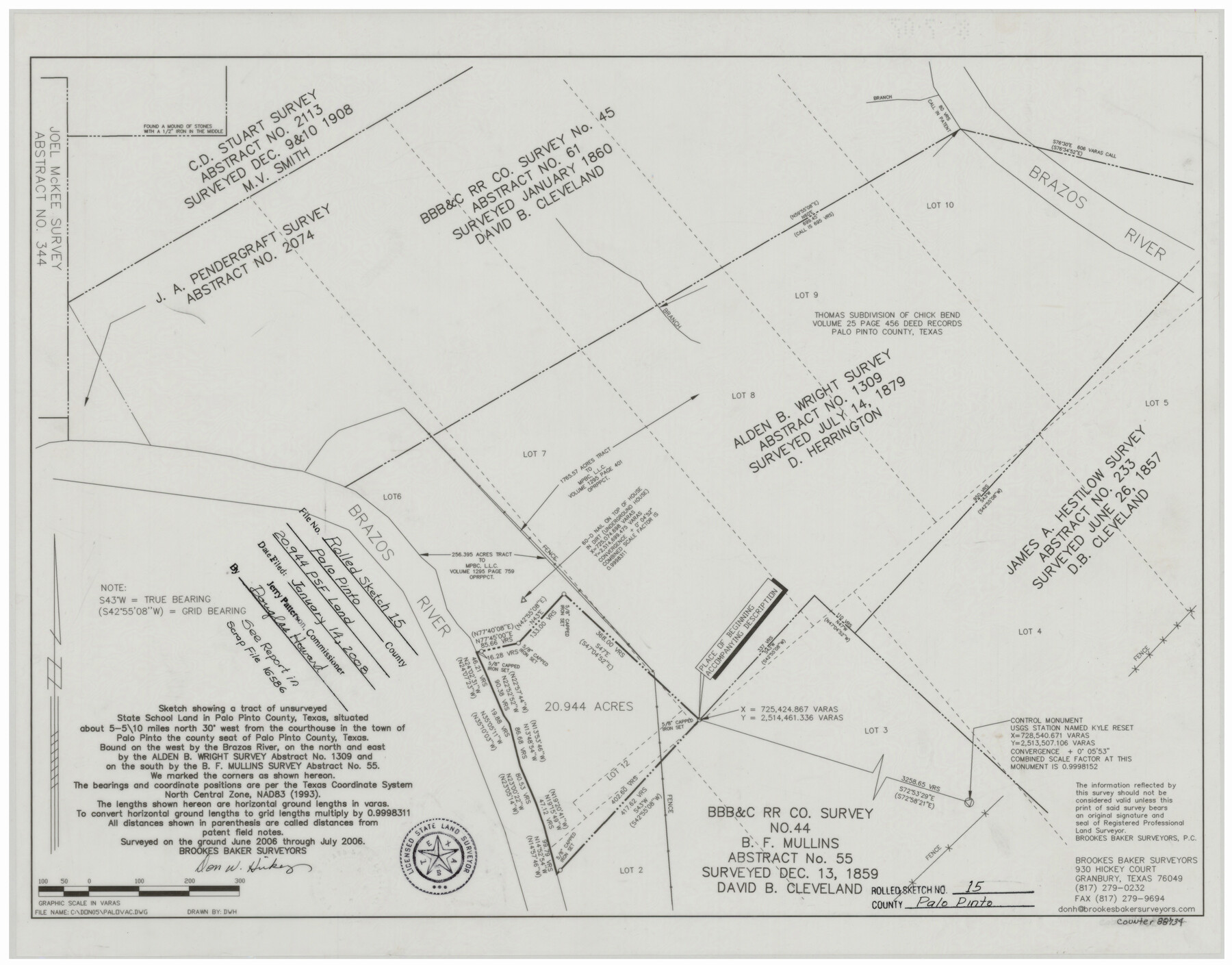
Palo Pinto County Rolled Sketch 15
Sketch showing a tract of unsurveyed State School Land in Palo Pinto County, Texas, bound on the west by the Brazos River, on the north and east by the Alden B. Wright survey abstract no. 1309 and on the south by the B.F. Mullins survey abstract no. 55
-
Map/Doc
88734
-
Collection
General Map Collection
-
Object Dates
2006 (Survey Date)
2008/1/14 (File Date)
-
People and Organizations
Don W. Hickey (Surveyor/Engineer)
-
Counties
Palo Pinto
-
Subjects
Surveying Rolled Sketch
-
Height x Width
19.2 x 24.5 inches
48.8 x 62.2 cm
-
Medium
mylar, print
-
Comments
See report in SF-16586.
Part of: General Map Collection
Frio County Working Sketch 10

Print $20.00
- Digital $50.00
Frio County Working Sketch 10
1951
Size 27.0 x 27.3 inches
Map/Doc 69284
Edwards County Working Sketch 77

Print $20.00
- Digital $50.00
Edwards County Working Sketch 77
1960
Size 32.8 x 39.9 inches
Map/Doc 68953
Calhoun County Rolled Sketch 10

Print $20.00
- Digital $50.00
Calhoun County Rolled Sketch 10
Size 32.9 x 29.2 inches
Map/Doc 5366
Sutton County Working Sketch 27

Print $20.00
- Digital $50.00
Sutton County Working Sketch 27
1891
Size 23.2 x 18.6 inches
Map/Doc 62370
Dimmit County Working Sketch 1

Print $20.00
- Digital $50.00
Dimmit County Working Sketch 1
1906
Size 23.6 x 22.7 inches
Map/Doc 68662
Chambers County NRC Article 33.136 Sketch 1

Print $62.00
- Digital $50.00
Chambers County NRC Article 33.136 Sketch 1
2002
Size 24.6 x 36.2 inches
Map/Doc 77041
Town Site of Marilou on Lake Placedo, Victoria County, Texas

Print $20.00
- Digital $50.00
Town Site of Marilou on Lake Placedo, Victoria County, Texas
1909
Size 17.0 x 22.6 inches
Map/Doc 77092
Brewster County Working Sketch 51

Print $40.00
- Digital $50.00
Brewster County Working Sketch 51
1950
Size 62.9 x 26.4 inches
Map/Doc 67585

Presidio County Rolled Sketch 24

Print $40.00
- Digital $50.00
Presidio County Rolled Sketch 24
1886
Size 158.3 x 23.4 inches
Map/Doc 9765
Henderson County Working Sketch 42

Print $20.00
- Digital $50.00
Henderson County Working Sketch 42
1990
Size 23.5 x 24.6 inches
Map/Doc 66175
Kerr County Sketch File 18

Print $20.00
- Digital $50.00
Kerr County Sketch File 18
1950
Size 16.9 x 20.3 inches
Map/Doc 11921
You may also like
El Paso County Rolled Sketch 52

Print $20.00
- Digital $50.00
El Paso County Rolled Sketch 52
1929
Size 18.5 x 24.5 inches
Map/Doc 5847
[Sketch showing area around Runnels County School Land, Yates survey 34 1/2 and Runnels County School Land]
![91681, [Sketch showing area around Runnels County School Land, Yates survey 34 1/2 and Runnels County School Land], Twichell Survey Records](https://historictexasmaps.com/wmedia_w700/maps/91681-1.tif.jpg)
Print $3.00
- Digital $50.00
[Sketch showing area around Runnels County School Land, Yates survey 34 1/2 and Runnels County School Land]
Size 15.8 x 9.7 inches
Map/Doc 91681
McLennan County Boundary File 1

Print $80.00
- Digital $50.00
McLennan County Boundary File 1
Size 19.4 x 12.3 inches
Map/Doc 56937
Crane County Working Sketch 29

Print $20.00
- Digital $50.00
Crane County Working Sketch 29
1976
Size 45.4 x 36.5 inches
Map/Doc 68306

Flight Mission No. CRC-1R, Frame 93, Chambers County

Print $20.00
- Digital $50.00
Flight Mission No. CRC-1R, Frame 93, Chambers County
1956
Size 18.7 x 22.6 inches
Map/Doc 84708
Water Valley Sheet, North Concho River, Tom Green County

Print $20.00
- Digital $50.00
Water Valley Sheet, North Concho River, Tom Green County
1937
Size 23.6 x 19.1 inches
Map/Doc 65305
Montgomery County Sketch File 10

Print $4.00
- Digital $50.00
Montgomery County Sketch File 10
Size 16.2 x 9.2 inches
Map/Doc 31798
Coleman County Working Sketch 2

Print $20.00
- Digital $50.00
Coleman County Working Sketch 2
1917
Size 15.0 x 16.8 inches
Map/Doc 68068
Hartley County

Print $20.00
- Digital $50.00
Hartley County
1891
Size 25.9 x 27.8 inches
Map/Doc 3639
Hutchinson County Working Sketch 19

Print $20.00
- Digital $50.00
Hutchinson County Working Sketch 19
1960
Size 18.8 x 18.3 inches
Map/Doc 66379
Robertson County Working Sketch 13

Print $20.00
- Digital $50.00
Robertson County Working Sketch 13
1987
Size 28.0 x 29.4 inches
Map/Doc 63586