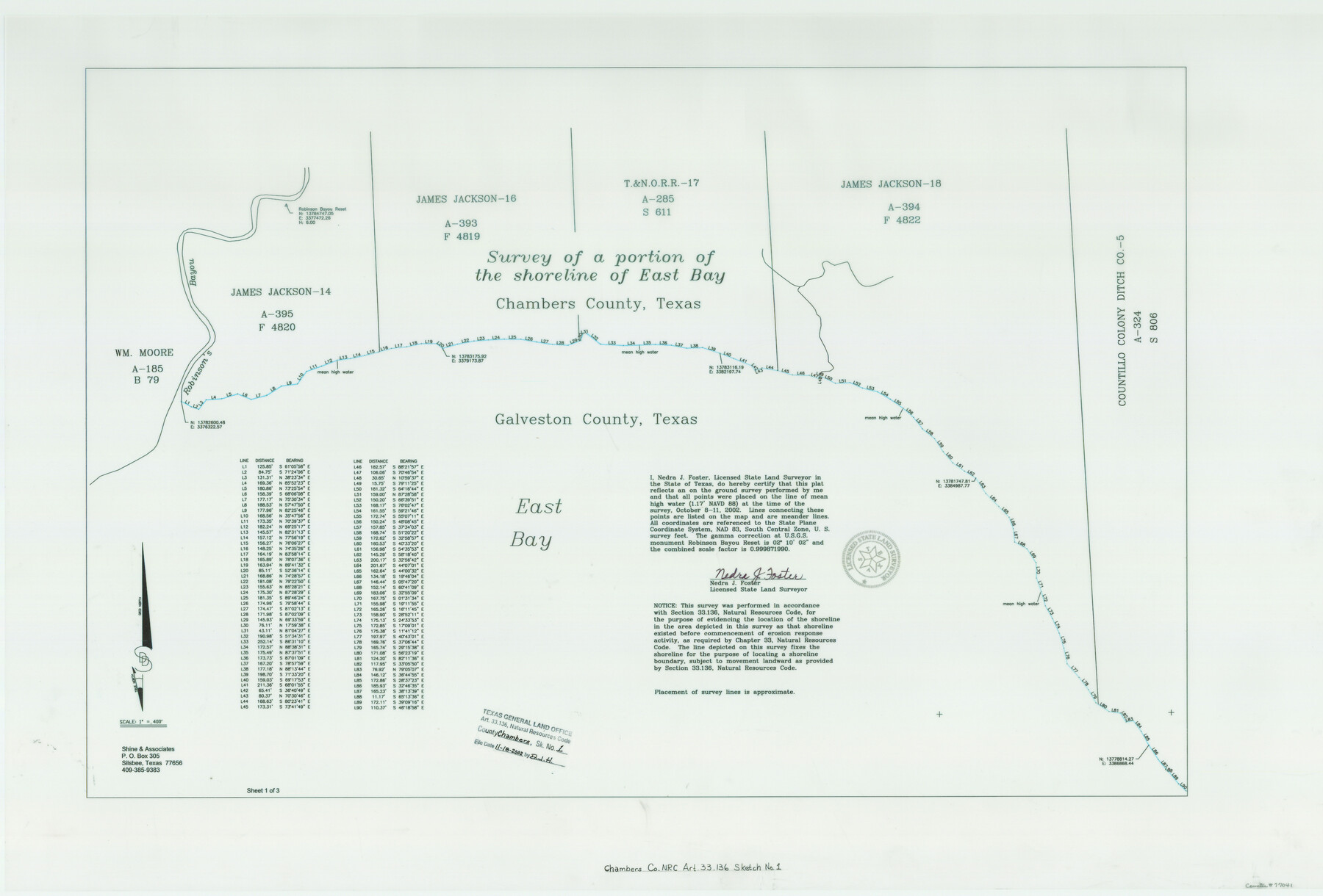
Chambers County NRC Article 33.136 Sketch 1
Survey of a Portion of the Shoreline of East Bay
-
Map/Doc
77041
-
Collection
General Map Collection
-
Object Dates
2002/10/11 (Creation Date)
2002/11/18 (File Date)
-
People and Organizations
Shine & Associates (Publisher)
Shine & Associates (Printer)
Nedra J. Foster (Surveyor/Engineer)
-
Counties
Chambers
-
Subjects
Surveying CBS
-
Height x Width
24.6 x 36.2 inches
62.5 x 91.9 cm
-
Medium
multi-page, multi-format
-
Comments
Survey located about 18 miles South 30 degrees East of Anahuca, Texas.
Part of: General Map Collection
San Jacinto River and Tributaries, Texas - Survey of 1939

Print $20.00
- Digital $50.00
San Jacinto River and Tributaries, Texas - Survey of 1939
1939
Size 27.7 x 40.4 inches
Map/Doc 60309
Midland County Rolled Sketch 14

Print $40.00
- Digital $50.00
Midland County Rolled Sketch 14
Size 56.6 x 43.5 inches
Map/Doc 73574
Collingsworth County Sketch File 7

Print $10.00
- Digital $50.00
Collingsworth County Sketch File 7
1915
Size 11.4 x 9.0 inches
Map/Doc 18884
Nueces County Rolled Sketch 68

Print $20.00
- Digital $50.00
Nueces County Rolled Sketch 68
1980
Size 19.9 x 25.4 inches
Map/Doc 6919
Cooke County Working Sketch 17

Print $20.00
- Digital $50.00
Cooke County Working Sketch 17
1950
Size 24.7 x 17.8 inches
Map/Doc 68254

Liberty County Rolled Sketch M

Print $40.00
- Digital $50.00
Liberty County Rolled Sketch M
1953
Size 23.6 x 56.6 inches
Map/Doc 10651
Brewster County Sketch File 53

Print $94.00
- Digital $50.00
Brewster County Sketch File 53
1910
Size 13.3 x 8.9 inches
Map/Doc 16361
La Salle County Sketch File 48

Print $6.00
- Digital $50.00
La Salle County Sketch File 48
1942
Size 11.2 x 8.8 inches
Map/Doc 29617
McCulloch County Rolled Sketch 4

Print $40.00
- Digital $50.00
McCulloch County Rolled Sketch 4
1901
Size 48.4 x 14.1 inches
Map/Doc 9498
Tyler County Rolled Sketch 3

Print $20.00
- Digital $50.00
Tyler County Rolled Sketch 3
1946
Size 45.5 x 35.6 inches
Map/Doc 10027
Brewster County Rolled Sketch 65

Print $40.00
- Digital $50.00
Brewster County Rolled Sketch 65
1940
Size 57.0 x 38.8 inches
Map/Doc 8489
You may also like
Flight Mission No. BRA-7M, Frame 147, Jefferson County

Print $20.00
- Digital $50.00
Flight Mission No. BRA-7M, Frame 147, Jefferson County
1953
Size 16.2 x 15.9 inches
Map/Doc 85541
A Map of Matagorda Bay and County With the Adjacent County

Print $20.00
- Digital $50.00
A Map of Matagorda Bay and County With the Adjacent County
1839
Size 33.9 x 43.1 inches
Map/Doc 4855
Gillespie County Working Sketch 12

Print $20.00
- Digital $50.00
Gillespie County Working Sketch 12
2007
Size 37.6 x 38.0 inches
Map/Doc 87903
Gregg County Working Sketch 11a

Print $20.00
- Digital $50.00
Gregg County Working Sketch 11a
1940
Size 26.2 x 32.9 inches
Map/Doc 63277
Irion County Working Sketch 9

Print $20.00
- Digital $50.00
Irion County Working Sketch 9
1941
Size 13.6 x 17.2 inches
Map/Doc 66418
[Castro, Lamb, Hockley, Swisher, Hale, and Lubbock Counties]
![91026, [Castro, Lamb, Hockley, Swisher, Hale, and Lubbock Counties], Twichell Survey Records](https://historictexasmaps.com/wmedia_w700/maps/91026-1.tif.jpg)
Print $20.00
- Digital $50.00
[Castro, Lamb, Hockley, Swisher, Hale, and Lubbock Counties]
Size 28.7 x 37.6 inches
Map/Doc 91026
Blucher's Directory Map of Corpus Christi and Road Map of Nueces County

Print $20.00
- Digital $50.00
Blucher's Directory Map of Corpus Christi and Road Map of Nueces County
1945
Size 22.7 x 34.4 inches
Map/Doc 94105
Chambers County Sketch File 20

Print $4.00
- Digital $50.00
Chambers County Sketch File 20
Size 9.2 x 7.4 inches
Map/Doc 17591
Aransas County NRC Article 33.136 Sketch 16

Print $24.00
- Digital $50.00
Aransas County NRC Article 33.136 Sketch 16
Size 24.0 x 36.0 inches
Map/Doc 95381
Frio County Rolled Sketch 22

Print $20.00
- Digital $50.00
Frio County Rolled Sketch 22
1962
Size 16.4 x 24.6 inches
Map/Doc 5923
Flight Mission No. DAG-21K, Frame 88, Matagorda County

Print $20.00
- Digital $50.00
Flight Mission No. DAG-21K, Frame 88, Matagorda County
1952
Size 18.6 x 22.4 inches
Map/Doc 86417
Jasper County Sketch File 24

Print $4.00
- Digital $50.00
Jasper County Sketch File 24
1925
Size 10.9 x 8.3 inches
Map/Doc 27824