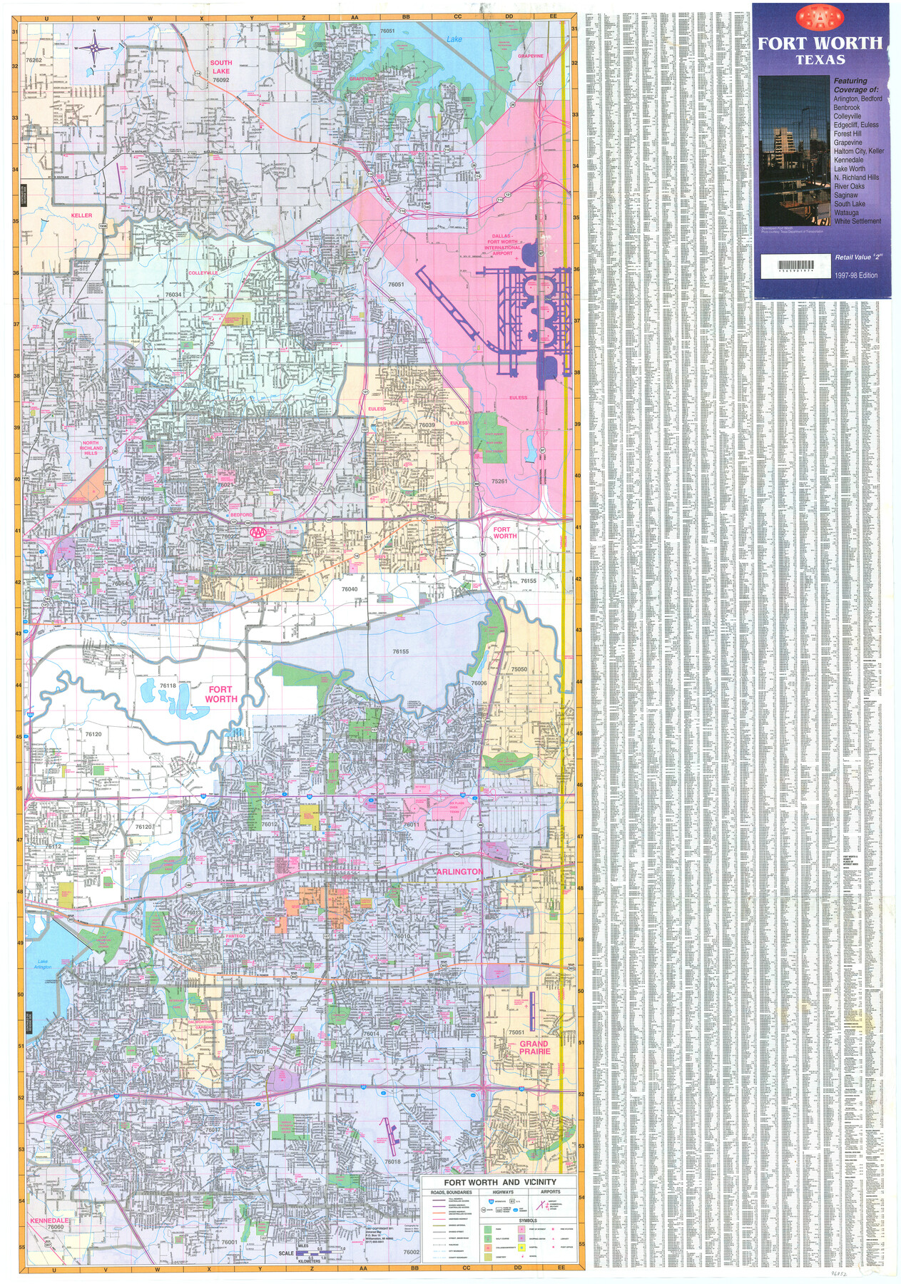
Fort Worth and Vicinity
-
Map/Doc
96852
-
Collection
General Map Collection
-
Object Dates
1997 (Creation Date)
-
People and Organizations
Universal Map (Publisher)
Mark Lambert (Donor)
Steven A. Winn (Cartographer)
Steven B. Melitz (Cartographer)
-
Counties
Tarrant
-
Subjects
City
-
Height x Width
38.6 x 27.1 inches
98.0 x 68.8 cm
-
Medium
paper, print
-
Comments
For research only. Donated by Mark Lambert in May, 2022. See 96851 for recto.
Related maps

Part of: General Map Collection
Old Miscellaneous File 13

Print $6.00
- Digital $50.00
Old Miscellaneous File 13
1899
Size 9.7 x 6.5 inches
Map/Doc 75446
Flight Mission No. CLL-1N, Frame 37, Willacy County

Print $20.00
- Digital $50.00
Flight Mission No. CLL-1N, Frame 37, Willacy County
1954
Size 18.4 x 22.0 inches
Map/Doc 87018
Ward County Sketch File 13

Print $14.00
- Digital $50.00
Ward County Sketch File 13
1951
Size 14.5 x 8.8 inches
Map/Doc 39640
Collingsworth County Rolled Sketch 1

Print $40.00
- Digital $50.00
Collingsworth County Rolled Sketch 1
1941
Size 58.0 x 27.0 inches
Map/Doc 8637
[Pecos and Northern Texas Ry., Bailey Co., from Parmer Co. line through Lariat and Muleshoe to Lamb Co. line]
![64635, [Pecos and Northern Texas Ry., Bailey Co., from Parmer Co. line through Lariat and Muleshoe to Lamb Co. line], General Map Collection](https://historictexasmaps.com/wmedia_w700/maps/64635.tif.jpg)
Print $40.00
- Digital $50.00
[Pecos and Northern Texas Ry., Bailey Co., from Parmer Co. line through Lariat and Muleshoe to Lamb Co. line]
1912
Size 19.5 x 121.6 inches
Map/Doc 64635
St. Louis Southwestern Railway of Texas

Print $20.00
- Digital $50.00
St. Louis Southwestern Railway of Texas
1906
Size 21.4 x 30.0 inches
Map/Doc 64450
Flight Mission No. DAG-17K, Frame 137, Matagorda County

Print $20.00
- Digital $50.00
Flight Mission No. DAG-17K, Frame 137, Matagorda County
1952
Size 16.5 x 16.2 inches
Map/Doc 86354
Archer County Sketch File 10

Print $5.00
- Digital $50.00
Archer County Sketch File 10
Size 10.2 x 15.9 inches
Map/Doc 13642
Denton County Sketch File 6

Print $4.00
- Digital $50.00
Denton County Sketch File 6
1855
Size 12.3 x 8.3 inches
Map/Doc 20696
Sutton County Boundary File 2

Print $22.00
- Digital $50.00
Sutton County Boundary File 2
Size 14.4 x 8.9 inches
Map/Doc 59004
Motley County

Print $20.00
- Digital $50.00
Motley County
1966
Size 43.8 x 34.8 inches
Map/Doc 73247
Colorado County Sketch File 7

Print $4.00
- Digital $50.00
Colorado County Sketch File 7
1862
Size 13.1 x 8.0 inches
Map/Doc 18925
You may also like

Wise County Sketch File 7

Print $4.00
- Digital $50.00
Wise County Sketch File 7
1857
Size 8.1 x 14.0 inches
Map/Doc 40535
Coleman County

Print $40.00
- Digital $50.00
Coleman County
1945
Size 54.5 x 35.4 inches
Map/Doc 77241


Aransas County Sketch File 30

Print $74.00
- Digital $50.00
Aransas County Sketch File 30
Size 14.2 x 8.7 inches
Map/Doc 13237
Flight Mission No. DCL-6C, Frame 66, Kenedy County

Print $20.00
- Digital $50.00
Flight Mission No. DCL-6C, Frame 66, Kenedy County
1943
Size 18.7 x 22.4 inches
Map/Doc 85908
Bell County Rolled Sketch 1

Print $20.00
- Digital $50.00
Bell County Rolled Sketch 1
1954
Size 38.1 x 41.1 inches
Map/Doc 75938
Trinity County Working Sketch 25

Print $20.00
- Digital $50.00
Trinity County Working Sketch 25
2010
Size 39.7 x 28.7 inches
Map/Doc 89600
Throckmorton County Boundary File 2

Print $34.00
- Digital $50.00
Throckmorton County Boundary File 2
Size 8.3 x 5.7 inches
Map/Doc 59264
Flight Mission No. DAG-26K, Frame 60, Matagorda County

Print $20.00
- Digital $50.00
Flight Mission No. DAG-26K, Frame 60, Matagorda County
1953
Size 18.7 x 22.7 inches
Map/Doc 86580
Bandera County

Print $40.00
- Digital $50.00
Bandera County
1947
Size 34.2 x 54.7 inches
Map/Doc 1777