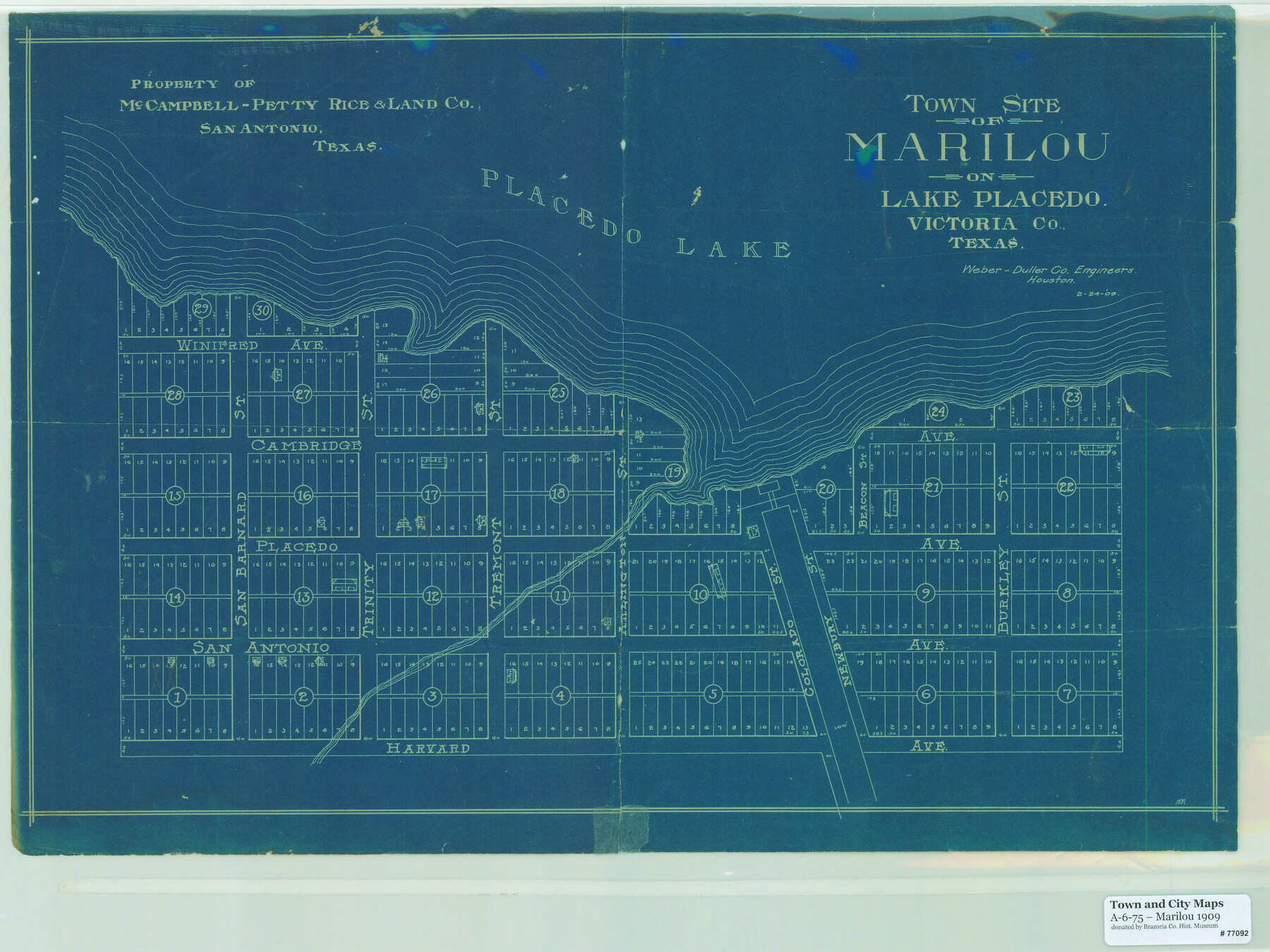
Town Site of Marilou on Lake Placedo, Victoria County, Texas
A-6-75
-
Map/Doc
77092
-
Collection
General Map Collection
-
Object Dates
1909/2/24 (Creation Date)
-
People and Organizations
Brazoria County Historical Museum (Donor)
Weber-Duller Co. Engineers (Surveyor/Engineer)
-
Counties
Victoria
-
Subjects
City
-
Height x Width
17.0 x 22.6 inches
43.2 x 57.4 cm
-
Medium
blueprint/diazo
-
Comments
Property of McCampbell-Petty Rice and Land Company, San Antonio, Texas.
Donated by Brazoria County Historical Museum on December 5, 2002. -
Features
Marilou
Placedo Lake
Part of: General Map Collection
Flight Mission No. BRA-7M, Frame 30, Jefferson County

Print $20.00
- Digital $50.00
Flight Mission No. BRA-7M, Frame 30, Jefferson County
1953
Size 18.6 x 22.3 inches
Map/Doc 85481
Red River County Working Sketch 81-3

Print $20.00
- Digital $50.00
Red River County Working Sketch 81-3
1987
Size 17.5 x 21.5 inches
Map/Doc 72066
Presidio County Working Sketch 94

Print $20.00
- Digital $50.00
Presidio County Working Sketch 94
1976
Size 40.6 x 32.1 inches
Map/Doc 71771
Val Verde County Sketch File B2

Print $20.00
- Digital $50.00
Val Verde County Sketch File B2
1910
Size 24.5 x 12.2 inches
Map/Doc 12544
Montague County Working Sketch 17

Print $20.00
- Digital $50.00
Montague County Working Sketch 17
1947
Size 22.1 x 30.0 inches
Map/Doc 71083
Dickens County Rolled Sketch 10

Print $20.00
- Digital $50.00
Dickens County Rolled Sketch 10
Size 43.0 x 31.9 inches
Map/Doc 8789
Bell County Sketch File 24

Print $4.00
- Digital $50.00
Bell County Sketch File 24
Size 10.0 x 8.0 inches
Map/Doc 14418
Real County Working Sketch 54

Print $20.00
- Digital $50.00
Real County Working Sketch 54
1960
Size 31.0 x 39.5 inches
Map/Doc 71946
Coast of Texas from head of East Bay Galveston Harbor to Sabine Pass

Print $40.00
- Digital $50.00
Coast of Texas from head of East Bay Galveston Harbor to Sabine Pass
1882
Size 32.2 x 54.1 inches
Map/Doc 69839
Panola County Sketch File 15

Print $4.00
- Digital $50.00
Panola County Sketch File 15
1882
Size 10.3 x 8.7 inches
Map/Doc 33474
Map of Surveys Made for the T&PRRCo in Howard, Mitchell & Tom Green Counties, Blocks 27, 28, 29, 30, 31, 32 & 33, Reserve West of the Colorado

Print $40.00
- Digital $50.00
Map of Surveys Made for the T&PRRCo in Howard, Mitchell & Tom Green Counties, Blocks 27, 28, 29, 30, 31, 32 & 33, Reserve West of the Colorado
1876
Size 42.0 x 51.0 inches
Map/Doc 2228
Haskell County Boundary File 4b

Print $40.00
- Digital $50.00
Haskell County Boundary File 4b
Size 28.6 x 19.7 inches
Map/Doc 54576
You may also like
Sketch of a portion of the Texas Coast showing the relative positions of different harbours with the interior Military Posts, and the roads communicating with them, also two new routes from Black Point and Lamar to San Antonio

Print $20.00
- Digital $50.00
Sketch of a portion of the Texas Coast showing the relative positions of different harbours with the interior Military Posts, and the roads communicating with them, also two new routes from Black Point and Lamar to San Antonio
1855
Size 27.3 x 18.3 inches
Map/Doc 72709
Map of Portion of Matagorda Bay in Matagorda County showing subdivision thereof for mineral development

Print $20.00
- Digital $50.00
Map of Portion of Matagorda Bay in Matagorda County showing subdivision thereof for mineral development
1937
Size 38.3 x 36.6 inches
Map/Doc 2921

Schleicher County Working Sketch 2

Print $20.00
- Digital $50.00
Schleicher County Working Sketch 2
1903
Size 14.7 x 19.4 inches
Map/Doc 63804
[Cotton Belt, St. Louis Southwestern Railway of Texas, Alignment through Smith County]
![64377, [Cotton Belt, St. Louis Southwestern Railway of Texas, Alignment through Smith County], General Map Collection](https://historictexasmaps.com/wmedia_w700/maps/64377.tif.jpg)
Print $20.00
- Digital $50.00
[Cotton Belt, St. Louis Southwestern Railway of Texas, Alignment through Smith County]
1903
Size 21.7 x 30.0 inches
Map/Doc 64377
General Highway Map, Hemphill County, Texas

Print $20.00
General Highway Map, Hemphill County, Texas
1940
Size 18.2 x 24.8 inches
Map/Doc 79124
Map of Dickens County

Print $20.00
- Digital $50.00
Map of Dickens County
1899
Size 41.1 x 37.7 inches
Map/Doc 4933
Deaf Smith County

Print $20.00
- Digital $50.00
Deaf Smith County
1926
Size 32.9 x 41.3 inches
Map/Doc 77260
Oldham County Rolled Sketch 12

Print $20.00
- Digital $50.00
Oldham County Rolled Sketch 12
1981
Size 25.2 x 38.0 inches
Map/Doc 7177
Controlled Mosaic by Jack Amman Photogrammetric Engineers, Inc - Sheet 34

Print $20.00
- Digital $50.00
Controlled Mosaic by Jack Amman Photogrammetric Engineers, Inc - Sheet 34
1954
Size 20.0 x 24.0 inches
Map/Doc 83487
Lynn County Working Sketch 2

Print $20.00
- Digital $50.00
Lynn County Working Sketch 2
1951
Size 19.8 x 42.5 inches
Map/Doc 70672
Dallas County Sketch File 18a

Print $20.00
- Digital $50.00
Dallas County Sketch File 18a
Size 12.4 x 23.8 inches
Map/Doc 11286