Dickens County Rolled Sketch 10
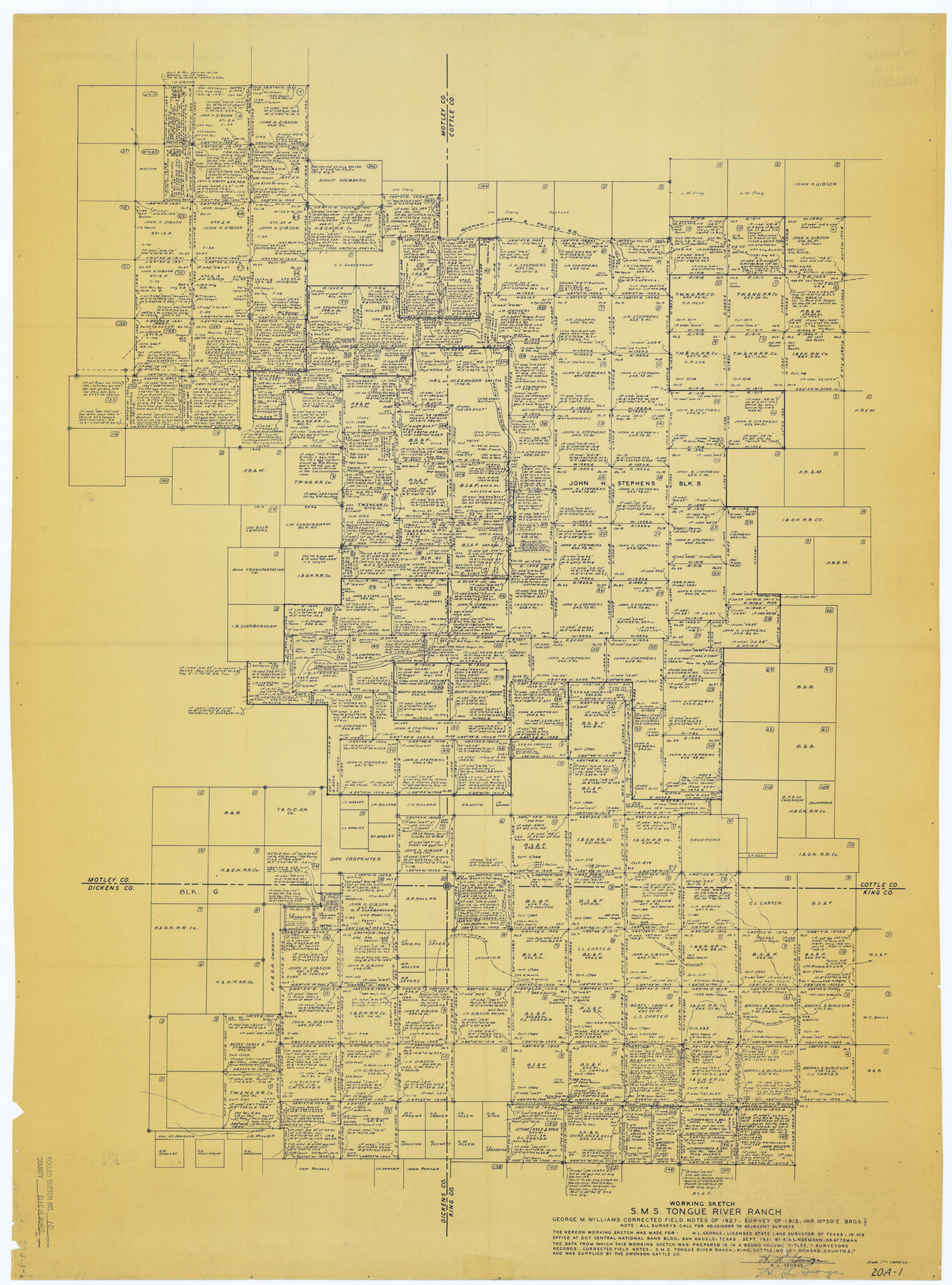
Working Sketch S. M. S. Tongue River Ranch
-
Map/Doc
8789
-
Collection
General Map Collection
-
Object Dates
1951 (Survey Date)
1954/5/15 (File Date)
-
People and Organizations
H.L. George (Surveyor/Engineer)
-
Counties
Dickens King Motley Cottle
-
Subjects
Surveying Rolled Sketch
-
Height x Width
43.0 x 31.9 inches
109.2 x 81.0 cm
-
Medium
blueprint/diazo
-
Scale
1" = 1000 varas
-
Comments
See Dickens County Rolled Sketch 9 (5708) for related sketch and see Dickens County Sketch File 35 (64791) for surveyor’s report.
Related maps
Dickens County Rolled Sketch 9

Print $20.00
- Digital $50.00
Dickens County Rolled Sketch 9
1954
Size 41.0 x 30.3 inches
Map/Doc 5708
Dickens County Sketch File 35

Print $10.00
- Digital $50.00
Dickens County Sketch File 35
1954
Size 11.2 x 8.9 inches
Map/Doc 64791
Part of: General Map Collection
Borden County Working Sketch 12

Print $20.00
- Digital $50.00
Borden County Working Sketch 12
1956
Size 43.1 x 37.0 inches
Map/Doc 67472
Real County Working Sketch 42

Print $20.00
- Digital $50.00
Real County Working Sketch 42
1953
Size 40.3 x 34.5 inches
Map/Doc 71934
Ward County Rolled Sketch A

Print $40.00
- Digital $50.00
Ward County Rolled Sketch A
Size 42.6 x 56.3 inches
Map/Doc 10099
Geological Map of the route explored by Capt. Jno. Pope, Corps of Topl. Engrs. near the 32nd Parallel of North Latitude From the Red River to the Rio Grande

Print $20.00
- Digital $50.00
Geological Map of the route explored by Capt. Jno. Pope, Corps of Topl. Engrs. near the 32nd Parallel of North Latitude From the Red River to the Rio Grande
Size 11.5 x 24.7 inches
Map/Doc 95149
Galveston County Rolled Sketch 34

Print $20.00
- Digital $50.00
Galveston County Rolled Sketch 34
1979
Size 28.0 x 39.7 inches
Map/Doc 5966
Sutton County Boundary File 2

Print $22.00
- Digital $50.00
Sutton County Boundary File 2
Size 14.4 x 8.9 inches
Map/Doc 59004
Kinney County Sketch File 11

Print $20.00
- Digital $50.00
Kinney County Sketch File 11
1885
Size 28.3 x 18.1 inches
Map/Doc 11939
La Salle County Sketch File 36

Print $40.00
- Digital $50.00
La Salle County Sketch File 36
1898
Size 12.2 x 12.6 inches
Map/Doc 29589
Orange County Sketch File 9b

Print $22.00
- Digital $50.00
Orange County Sketch File 9b
1873
Size 14.6 x 12.6 inches
Map/Doc 33315
Kinney County Sketch File E1

Print $20.00
- Digital $50.00
Kinney County Sketch File E1
1885
Size 29.8 x 31.9 inches
Map/Doc 10619
San Patricio County Rolled Sketch 29B

Print $20.00
- Digital $50.00
San Patricio County Rolled Sketch 29B
1936
Size 25.8 x 31.0 inches
Map/Doc 7582
Gonzales County Working Sketch 13

Print $2.00
- Digital $50.00
Gonzales County Working Sketch 13
1981
Size 12.5 x 7.6 inches
Map/Doc 63229
You may also like

Southern Part of Laguna Madre

Print $20.00
- Digital $50.00
Southern Part of Laguna Madre
1960
Size 44.1 x 34.6 inches
Map/Doc 73538
Lipscomb County Sketch File 1

Print $40.00
- Digital $50.00
Lipscomb County Sketch File 1
Size 51.7 x 14.2 inches
Map/Doc 10525
Map of the City of Corsicana (Navarro County) Texas

Print $40.00
- Digital $50.00
Map of the City of Corsicana (Navarro County) Texas
1963
Size 40.1 x 91.8 inches
Map/Doc 93674
[Corpus Christi Bay, Padre Island, Mustang Island, Laguna de la Madre, King and Kenedy's Pasture]
![73047, [Corpus Christi Bay, Padre Island, Mustang Island, Laguna de la Madre, King and Kenedy's Pasture], General Map Collection](https://historictexasmaps.com/wmedia_w700/maps/73047.tif.jpg)
Print $20.00
- Digital $50.00
[Corpus Christi Bay, Padre Island, Mustang Island, Laguna de la Madre, King and Kenedy's Pasture]
Size 18.2 x 26.0 inches
Map/Doc 73047
St. L. S-W. Ry. of Texas Map of Lufkin Branch in Cherokee County Texas

Print $40.00
- Digital $50.00
St. L. S-W. Ry. of Texas Map of Lufkin Branch in Cherokee County Texas
1912
Size 23.4 x 121.6 inches
Map/Doc 64016
Map of Hardin County

Print $20.00
- Digital $50.00
Map of Hardin County
1902
Size 40.8 x 43.9 inches
Map/Doc 4971
Mitchell County Sketch File 12

Print $20.00
- Digital $50.00
Mitchell County Sketch File 12
1912
Size 25.6 x 14.0 inches
Map/Doc 12099
Flight Mission No. CUG-2P, Frame 82, Kleberg County

Print $20.00
- Digital $50.00
Flight Mission No. CUG-2P, Frame 82, Kleberg County
1956
Size 18.5 x 22.3 inches
Map/Doc 86214
Navigation Maps of Gulf Intracoastal Waterway, Port Arthur to Brownsville, Texas

Print $4.00
- Digital $50.00
Navigation Maps of Gulf Intracoastal Waterway, Port Arthur to Brownsville, Texas
1951
Size 16.8 x 21.3 inches
Map/Doc 65450
Panola County Sketch File 7

Print $4.00
- Digital $50.00
Panola County Sketch File 7
Size 7.7 x 9.9 inches
Map/Doc 33457
Carson County Boundary File 5b

Print $10.00
- Digital $50.00
Carson County Boundary File 5b
Size 11.7 x 8.6 inches
Map/Doc 51141