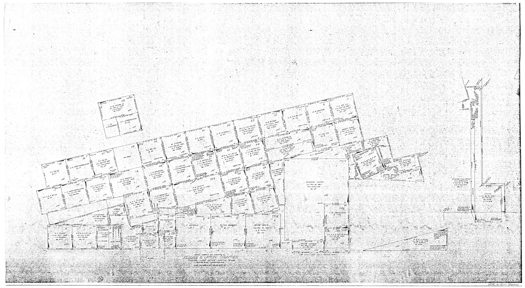
Reagan County Working Sketch 20
-
Map/Doc
71862
-
Collection
General Map Collection
-
Object Dates
1/29/1954 (Creation Date)
-
People and Organizations
Herman Forbes (Draftsman)
-
Counties
Reagan Upton
-
Subjects
Surveying Working Sketch
-
Height x Width
37.5 x 68.2 inches
95.3 x 173.2 cm
-
Scale
1" = 500 varas
Part of: General Map Collection
Harris County Sketch File 65

Print $20.00
- Digital $50.00
Harris County Sketch File 65
Size 23.5 x 35.1 inches
Map/Doc 11660
Brewster County Working Sketch 105

Print $40.00
- Digital $50.00
Brewster County Working Sketch 105
1980
Size 42.5 x 77.6 inches
Map/Doc 67705
Galveston County NRC Article 33.136 Sketch 78

Print $24.00
- Digital $50.00
Galveston County NRC Article 33.136 Sketch 78
2015
Size 36.0 x 24.0 inches
Map/Doc 95129
[Map of Chicago, Rock Island & Texas Railway through Tarrant County, Texas]
![64413, [Map of Chicago, Rock Island & Texas Railway through Tarrant County, Texas], General Map Collection](https://historictexasmaps.com/wmedia_w700/maps/64413.tif.jpg)
Print $40.00
- Digital $50.00
[Map of Chicago, Rock Island & Texas Railway through Tarrant County, Texas]
1893
Size 22.3 x 121.8 inches
Map/Doc 64413
Rains County Boundary File 1

Print $6.00
- Digital $50.00
Rains County Boundary File 1
Size 11.3 x 8.8 inches
Map/Doc 58090
Brewster County Sketch File 39

Print $4.00
- Digital $50.00
Brewster County Sketch File 39
Size 12.8 x 8.9 inches
Map/Doc 16300
Preliminary Chart of Galveston Bay, Texas

Print $20.00
- Digital $50.00
Preliminary Chart of Galveston Bay, Texas
1855
Size 20.9 x 17.5 inches
Map/Doc 69868
Dickens County Boundary File 2

Print $52.00
- Digital $50.00
Dickens County Boundary File 2
Size 8.9 x 4.2 inches
Map/Doc 52533
McMullen County Rolled Sketch 8

Print $20.00
- Digital $50.00
McMullen County Rolled Sketch 8
Size 26.0 x 26.3 inches
Map/Doc 6725
Clay County Working Sketch 3

Print $20.00
- Digital $50.00
Clay County Working Sketch 3
1923
Size 19.7 x 9.3 inches
Map/Doc 68026

Erath County Rolled Sketch 1

Print $40.00
- Digital $50.00
Erath County Rolled Sketch 1
1962
Size 37.6 x 69.0 inches
Map/Doc 8882
You may also like
[Val Verde County]
![63096, [Val Verde County], General Map Collection](https://historictexasmaps.com/wmedia_w700/maps/63096.tif.jpg)
Print $20.00
- Digital $50.00
[Val Verde County]
1898
Size 42.6 x 34.9 inches
Map/Doc 63096
Webb County Rolled Sketch 44

Print $20.00
- Digital $50.00
Webb County Rolled Sketch 44
1941
Size 23.9 x 20.1 inches
Map/Doc 8199
Val Verde County Working Sketch 59

Print $20.00
- Digital $50.00
Val Verde County Working Sketch 59
1958
Size 38.6 x 35.0 inches
Map/Doc 72194
Motley County Sketch File 32 (S)

Print $4.00
- Digital $50.00
Motley County Sketch File 32 (S)
Size 11.3 x 8.7 inches
Map/Doc 32215
Jefferson County Working Sketch 21

Print $40.00
- Digital $50.00
Jefferson County Working Sketch 21
1969
Size 31.3 x 60.5 inches
Map/Doc 66564
Flight Mission No. DQO-3K, Frame 26, Galveston County

Print $20.00
- Digital $50.00
Flight Mission No. DQO-3K, Frame 26, Galveston County
1952
Size 17.4 x 18.9 inches
Map/Doc 85067
Aransas Pass to Baffin Bay

Print $20.00
- Digital $50.00
Aransas Pass to Baffin Bay
1961
Size 42.1 x 35.4 inches
Map/Doc 73414
Lubbock County

Print $20.00
- Digital $50.00
Lubbock County
1968
Size 44.2 x 35.8 inches
Map/Doc 95576
Lavaca County

Print $40.00
- Digital $50.00
Lavaca County
1946
Size 51.1 x 42.8 inches
Map/Doc 73216
Galveston County Working Sketch 24

Print $20.00
- Digital $50.00
Galveston County Working Sketch 24
1939
Size 16.6 x 19.6 inches
Map/Doc 69361
Crockett County Sketch File H

Print $26.00
- Digital $50.00
Crockett County Sketch File H
1920
Size 14.4 x 9.0 inches
Map/Doc 19638
Crockett County Rolled Sketch JAS

Print $40.00
- Digital $50.00
Crockett County Rolled Sketch JAS
1938
Size 52.9 x 42.7 inches
Map/Doc 8699