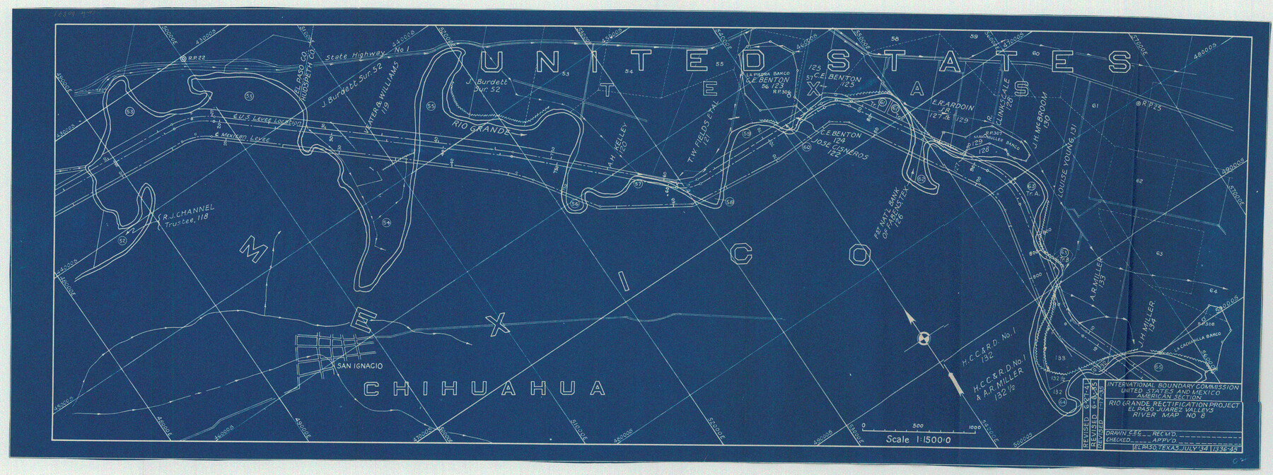
Rio Grande Rectification Project, El Paso and Juarez Valley
Rio Grande from El Paso-Hudspeth Co. line east to about Quitman Canyon
N-1-9
-
Map/Doc
60871
-
Collection
General Map Collection
-
Object Dates
1935 (Creation Date)
-
Subjects
River Surveys Texas Boundaries
-
Height x Width
11.0 x 29.6 inches
27.9 x 75.2 cm
Part of: General Map Collection
Map of a portion of the City of Galveston, Texas showing proposed location of Sea Wall and Right of Way to be obtained
![73625, Map of a portion of the City of Galveston, Texas showing proposed location of Sea Wall and Right of Way to be obtained, General Map Collection](https://historictexasmaps.com/wmedia_w700/maps/73625-2.tif.jpg)
Print $20.00
- Digital $50.00
Map of a portion of the City of Galveston, Texas showing proposed location of Sea Wall and Right of Way to be obtained
1902
Size 16.5 x 38.5 inches
Map/Doc 73625
General Chart of the Coast No. XVI - Gulf Coast from Galveston to the Rio Grande
![72736, General Chart of the Coast No. XVI - Gulf Coast from Galveston to the Rio Grande, General Map Collection](https://historictexasmaps.com/wmedia_w700/maps/72736.tif.jpg)
Print $20.00
- Digital $50.00
General Chart of the Coast No. XVI - Gulf Coast from Galveston to the Rio Grande
1883
Size 26.8 x 18.2 inches
Map/Doc 72736
Rusk County Working Sketch 24
![63660, Rusk County Working Sketch 24, General Map Collection](https://historictexasmaps.com/wmedia_w700/maps/63660.tif.jpg)
Print $20.00
- Digital $50.00
Rusk County Working Sketch 24
Size 20.2 x 24.7 inches
Map/Doc 63660
San Patricio County Rolled Sketch 46G
![8378, San Patricio County Rolled Sketch 46G, General Map Collection](https://historictexasmaps.com/wmedia_w700/maps/8378.tif.jpg)
Print $40.00
- Digital $50.00
San Patricio County Rolled Sketch 46G
1983
Size 31.2 x 50.0 inches
Map/Doc 8378
Flight Mission No. BRA-7M, Frame 130, Jefferson County
![85524, Flight Mission No. BRA-7M, Frame 130, Jefferson County, General Map Collection](https://historictexasmaps.com/wmedia_w700/pdf_converted_jpg/qi_pdf_thumbnail_32724.jpg)
Print $20.00
- Digital $50.00
Flight Mission No. BRA-7M, Frame 130, Jefferson County
1953
Size 16.2 x 16.0 inches
Map/Doc 85524
Walker County Working Sketch 16
![72296, Walker County Working Sketch 16, General Map Collection](https://historictexasmaps.com/wmedia_w700/maps/72296.tif.jpg)
Print $20.00
- Digital $50.00
Walker County Working Sketch 16
Size 36.5 x 42.4 inches
Map/Doc 72296
Lubbock County Sketch File 12
![30435, Lubbock County Sketch File 12, General Map Collection](https://historictexasmaps.com/wmedia_w700/pdf_converted_jpg/qi_pdf_thumbnail_12820.jpg)
Print $6.00
- Digital $50.00
Lubbock County Sketch File 12
1933
Size 11.1 x 8.6 inches
Map/Doc 30435
Starr County Sketch File 42
![12341, Starr County Sketch File 42, General Map Collection](https://historictexasmaps.com/wmedia_w700/pdf_converted_jpg/qi_pdf_thumbnail_8660.jpg)
Print $20.00
- Digital $50.00
Starr County Sketch File 42
1941
Size 19.0 x 21.6 inches
Map/Doc 12341
Harris County Working Sketch 38
![65930, Harris County Working Sketch 38, General Map Collection](https://historictexasmaps.com/wmedia_w700/maps/65930.tif.jpg)
Print $20.00
- Digital $50.00
Harris County Working Sketch 38
Size 23.6 x 23.7 inches
Map/Doc 65930
Presidio County Rolled Sketch 86
![7372, Presidio County Rolled Sketch 86, General Map Collection](https://historictexasmaps.com/wmedia_w700/maps/7372.tif.jpg)
Print $20.00
- Digital $50.00
Presidio County Rolled Sketch 86
1945
Size 34.1 x 27.8 inches
Map/Doc 7372
Crockett County Working Sketch 54
![68387, Crockett County Working Sketch 54, General Map Collection](https://historictexasmaps.com/wmedia_w700/maps/68387.tif.jpg)
Print $20.00
- Digital $50.00
Crockett County Working Sketch 54
Size 34.5 x 30.7 inches
Map/Doc 68387
Menard County Working Sketch 1
![70948, Menard County Working Sketch 1, General Map Collection](https://historictexasmaps.com/wmedia_w700/maps/70948.tif.jpg)
Print $20.00
- Digital $50.00
Menard County Working Sketch 1
Size 23.3 x 18.9 inches
Map/Doc 70948
You may also like
[Charles Welch, J. D. Brown, and surrounding surveys]
![91010, [Charles Welch, J. D. Brown, and surrounding surveys], Twichell Survey Records](https://historictexasmaps.com/wmedia_w700/maps/91010-1.tif.jpg)
Print $20.00
- Digital $50.00
[Charles Welch, J. D. Brown, and surrounding surveys]
Size 37.4 x 24.0 inches
Map/Doc 91010
[Texas and Pacific Railway Company, Block 44, Township One South]
![89845, [Texas and Pacific Railway Company, Block 44, Township One South], Twichell Survey Records](https://historictexasmaps.com/wmedia_w700/maps/89845-1.tif.jpg)
Print $40.00
- Digital $50.00
[Texas and Pacific Railway Company, Block 44, Township One South]
Size 42.0 x 59.2 inches
Map/Doc 89845
Pecos County Sketch File 56
![10571, Pecos County Sketch File 56, General Map Collection](https://historictexasmaps.com/wmedia_w700/pdf_converted_jpg/qi_pdf_thumbnail_7220.jpg)
Print $20.00
- Digital $50.00
Pecos County Sketch File 56
Size 35.6 x 28.6 inches
Map/Doc 10571
Schleicher County Working Sketch 22
![63824, Schleicher County Working Sketch 22, General Map Collection](https://historictexasmaps.com/wmedia_w700/maps/63824.tif.jpg)
Print $20.00
- Digital $50.00
Schleicher County Working Sketch 22
Size 26.2 x 15.3 inches
Map/Doc 63824
Intracoastal Waterway in Texas - Corpus Christi to Point Isabel including Arroyo Colorado to Mo. Pac. R.R. Bridge Near Harlingen
![61878, Intracoastal Waterway in Texas - Corpus Christi to Point Isabel including Arroyo Colorado to Mo. Pac. R.R. Bridge Near Harlingen, General Map Collection](https://historictexasmaps.com/wmedia_w700/maps/61878.tif.jpg)
Print $20.00
- Digital $50.00
Intracoastal Waterway in Texas - Corpus Christi to Point Isabel including Arroyo Colorado to Mo. Pac. R.R. Bridge Near Harlingen
1933
Size 27.9 x 40.8 inches
Map/Doc 61878
Atascosa County
![3249, Atascosa County, General Map Collection](https://historictexasmaps.com/wmedia_w700/maps/3249-1.tif.jpg)
Print $20.00
- Digital $50.00
Atascosa County
1873
Size 22.2 x 23.1 inches
Map/Doc 3249
Sketch of Part of Crockett County, Texas
![92545, Sketch of Part of Crockett County, Texas, Twichell Survey Records](https://historictexasmaps.com/wmedia_w700/maps/92545.tif.jpg)
Print $20.00
- Digital $50.00
Sketch of Part of Crockett County, Texas
1925
Size 20.0 x 18.0 inches
Map/Doc 92545
Dallam County Working Sketch Graphic Index
![76516, Dallam County Working Sketch Graphic Index, General Map Collection](https://historictexasmaps.com/wmedia_w700/maps/76516-1.tif.jpg)
Print $40.00
- Digital $50.00
Dallam County Working Sketch Graphic Index
1926
Size 41.3 x 50.9 inches
Map/Doc 76516
Culberson County Working Sketch 58
![68512, Culberson County Working Sketch 58, General Map Collection](https://historictexasmaps.com/wmedia_w700/maps/68512.tif.jpg)
Print $20.00
- Digital $50.00
Culberson County Working Sketch 58
Size 45.2 x 35.1 inches
Map/Doc 68512
Flight Mission No. BRA-6M, Frame 92, Jefferson County
![85435, Flight Mission No. BRA-6M, Frame 92, Jefferson County, General Map Collection](https://historictexasmaps.com/wmedia_w700/pdf_converted_jpg/qi_pdf_thumbnail_32635.jpg)
Print $20.00
- Digital $50.00
Flight Mission No. BRA-6M, Frame 92, Jefferson County
1953
Size 18.5 x 22.3 inches
Map/Doc 85435
Cherokee County Sketch File 10
![18136, Cherokee County Sketch File 10, General Map Collection](https://historictexasmaps.com/wmedia_w700/pdf_converted_jpg/qi_pdf_thumbnail_10065.jpg)
Print $4.00
- Digital $50.00
Cherokee County Sketch File 10
1847
Size 8.2 x 9.5 inches
Map/Doc 18136