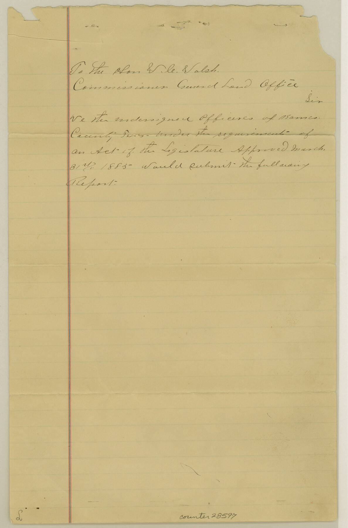
Karnes County Sketch File 10
[Report by Karnes County Assessor and Surveyor regarding multiple conflicts and invalid surveys throughout the county]
-
Map/Doc
28597
-
Collection
General Map Collection
-
Object Dates
8/24/1885 (Creation Date)
-
People and Organizations
W.G. Seale (Surveyor/Engineer)
L.G. Bailey (Surveyor/Engineer)
-
Counties
Karnes
-
Subjects
Surveying Sketch File
-
Height x Width
12.8 x 8.5 inches
32.5 x 21.6 cm
-
Medium
paper, manuscript
Related maps
Karnes County Sketch File 11

Print $4.00
- Digital $50.00
Karnes County Sketch File 11
1885
Size 10.5 x 8.1 inches
Map/Doc 28602
Part of: General Map Collection
Nueces River, Corpus Christi Sheet No. 6

Print $6.00
- Digital $50.00
Nueces River, Corpus Christi Sheet No. 6
1938
Size 31.3 x 31.0 inches
Map/Doc 65095

[The S.K. Ry. of Texas, State Line to Pecos, Reeves Co., Texas]
![64159, [The S.K. Ry. of Texas, State Line to Pecos, Reeves Co., Texas], General Map Collection](https://historictexasmaps.com/wmedia_w700/maps/64159.tif.jpg)
Print $40.00
- Digital $50.00
[The S.K. Ry. of Texas, State Line to Pecos, Reeves Co., Texas]
1910
Size 19.4 x 130.6 inches
Map/Doc 64159
Reagan County Rolled Sketch 17

Print $20.00
- Digital $50.00
Reagan County Rolled Sketch 17
Size 33.9 x 32.6 inches
Map/Doc 10623
Martin County Working Sketch 11

Print $40.00
- Digital $50.00
Martin County Working Sketch 11
1971
Size 49.8 x 38.1 inches
Map/Doc 70829
Corpus Christi Bay in Nueces County, showing Subdivision for Mineral Development

Print $40.00
- Digital $50.00
Corpus Christi Bay in Nueces County, showing Subdivision for Mineral Development
1950
Size 48.4 x 36.0 inches
Map/Doc 1917
Travis County Boundary File 6

Print $109.00
- Digital $50.00
Travis County Boundary File 6
Size 14.6 x 9.1 inches
Map/Doc 59433
PSL Field Notes for Blocks 15 through 29 in Hudspeth County

PSL Field Notes for Blocks 15 through 29 in Hudspeth County
Map/Doc 81659
Dawson County Working Sketch 2

Print $20.00
- Digital $50.00
Dawson County Working Sketch 2
1937
Size 8.8 x 20.3 inches
Map/Doc 68546
Upton County Sketch File 5

Print $40.00
- Digital $50.00
Upton County Sketch File 5
Size 8.7 x 24.4 inches
Map/Doc 38813
Houston County

Print $20.00
- Digital $50.00
Houston County
1888
Size 24.5 x 26.1 inches
Map/Doc 3683
Flight Mission No. DQO-1K, Frame 39, Galveston County

Print $20.00
- Digital $50.00
Flight Mission No. DQO-1K, Frame 39, Galveston County
1952
Size 18.8 x 22.6 inches
Map/Doc 84982
You may also like
Calhoun County Rolled Sketch 9

Print $20.00
- Digital $50.00
Calhoun County Rolled Sketch 9
Size 24.4 x 38.7 inches
Map/Doc 5365
Crockett County Rolled Sketch 3

Print $20.00
- Digital $50.00
Crockett County Rolled Sketch 3
1886
Size 18.1 x 22.9 inches
Map/Doc 5579
Topographic Map of Texas and Oklahoma Boundary, Fort Augur Area

Print $20.00
Topographic Map of Texas and Oklahoma Boundary, Fort Augur Area
1924
Size 20.3 x 33.0 inches
Map/Doc 79753
Flight Mission No. DQO-8K, Frame 22, Galveston County

Print $20.00
- Digital $50.00
Flight Mission No. DQO-8K, Frame 22, Galveston County
1952
Size 18.7 x 22.3 inches
Map/Doc 85145
Jefferson County Rolled Sketch 17

Print $40.00
- Digital $50.00
Jefferson County Rolled Sketch 17
1931
Size 18.7 x 72.6 inches
Map/Doc 9281
Stonewall County Working Sketch Graphic Index - sheet A

Print $20.00
- Digital $50.00
Stonewall County Working Sketch Graphic Index - sheet A
1933
Size 43.3 x 36.2 inches
Map/Doc 76704
Rains County Working Sketch 8

Print $20.00
- Digital $50.00
Rains County Working Sketch 8
1965
Size 24.3 x 28.1 inches
Map/Doc 71834
[Surveys in the Milam District]
![69729, [Surveys in the Milam District], General Map Collection](https://historictexasmaps.com/wmedia_w700/maps/69729.tif.jpg)
Print $2.00
- Digital $50.00
[Surveys in the Milam District]
1845
Size 9.5 x 6.7 inches
Map/Doc 69729
Webb County Sketch File EF

Print $38.00
- Digital $50.00
Webb County Sketch File EF
1932
Size 9.2 x 8.5 inches
Map/Doc 39681
Aransas County NRC Article 33.136 Sketch 15

Print $42.00
- Digital $50.00
Aransas County NRC Article 33.136 Sketch 15
Size 24.0 x 36.0 inches
Map/Doc 95316
Map of Harris County Showing Abandoned Surveys

Print $40.00
- Digital $50.00
Map of Harris County Showing Abandoned Surveys
1938
Size 42.5 x 67.1 inches
Map/Doc 2053
Galveston County NRC Article 33.136 Sketch 36

Print $28.00
- Digital $50.00
Galveston County NRC Article 33.136 Sketch 36
2005
Size 24.5 x 36.6 inches
Map/Doc 83409