Foard County Sketch File 2

Print $40.00
- Digital $50.00
Foard County Sketch File 2
Size: 23.8 x 16.3 inches
11490
Palo Pinto County Sketch File 1

Print $20.00
- Digital $50.00
Palo Pinto County Sketch File 1
Size: 18.8 x 23.5 inches
12131
Stephens County Sketch File 1B

Print $20.00
- Digital $50.00
Stephens County Sketch File 1B
Size: 12.9 x 28.2 inches
12348
Young County Sketch File 10

Print $20.00
- Digital $50.00
Young County Sketch File 10
Size: 14.1 x 17.7 inches
12711
Young County Sketch File 17

Print $20.00
- Digital $50.00
Young County Sketch File 17
Size: 18.5 x 24.3 inches
12713
Jack County Sketch File 13

Print $4.00
- Digital $50.00
Jack County Sketch File 13
Size: 10.3 x 8.0 inches
27537
Young County Sketch File 6

Print $14.00
- Digital $50.00
Young County Sketch File 6
Size: 13.0 x 8.2 inches
40852
Young County Sketch File 19

Print $34.00
- Digital $50.00
Young County Sketch File 19
Size: 14.5 x 8.9 inches
40887
Young County Boundary File 1

Print $8.00
- Digital $50.00
Young County Boundary File 1
Size: 10.3 x 8.2 inches
60198
Young County Boundary File 2

Print $6.00
- Digital $50.00
Young County Boundary File 2
Size: 14.2 x 8.7 inches
60202
Young County Boundary File 98

Print $12.00
- Digital $50.00
Young County Boundary File 98
Size: 8.8 x 7.5 inches
60205
Young County Boundary File 98a

Print $32.00
- Digital $50.00
Young County Boundary File 98a
Size: 10.2 x 8.0 inches
60211
Map of the Recognised Line, M. El. P. & P. RR. from Texas & Arkansas State Line to Milam & Bexar Land District Line

Print $40.00
- Digital $50.00
Map of the Recognised Line, M. El. P. & P. RR. from Texas & Arkansas State Line to Milam & Bexar Land District Line
Size: 15.3 x 89.4 inches
64638
Young County Rolled Sketch 2

Print $20.00
- Digital $50.00
Young County Rolled Sketch 2
Size: 26.2 x 25.0 inches
8292
Young County Rolled Sketch 5

Print $20.00
- Digital $50.00
Young County Rolled Sketch 5
Size: 20.2 x 26.1 inches
8293
Young County Rolled Sketch 6

Print $20.00
- Digital $50.00
Young County Rolled Sketch 6
Size: 43.4 x 30.8 inches
8294
Young County Rolled Sketch 7

Print $20.00
- Digital $50.00
Young County Rolled Sketch 7
Size: 37.3 x 26.4 inches
8295
Young County Rolled Sketch 8

Print $20.00
- Digital $50.00
Young County Rolled Sketch 8
Size: 40.5 x 25.8 inches
8296
Young County Rolled Sketch 11

Print $20.00
- Digital $50.00
Young County Rolled Sketch 11
Size: 14.9 x 23.1 inches
8299
Young County Rolled Sketch 12

Print $20.00
- Digital $50.00
Young County Rolled Sketch 12
Size: 24.2 x 17.9 inches
8300
Young County Rolled Sketch 15

Print $20.00
- Digital $50.00
Young County Rolled Sketch 15
Size: 18.0 x 22.7 inches
8303
Map No. 3 by W. D. Twichell

Print $20.00
- Digital $50.00
Map No. 3 by W. D. Twichell
Size: 42.5 x 32.9 inches
89710
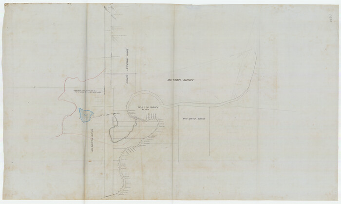
[River Meander along Jas. Tobin Survey and others]
Print $40.00
- Digital $50.00
[River Meander along Jas. Tobin Survey and others]
Size: 73.6 x 43.9 inches
89814
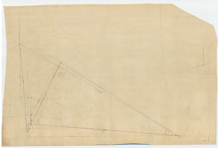
[Triangulation Sketch]
Print $40.00
- Digital $50.00
[Triangulation Sketch]
Size: 56.0 x 38.0 inches
89815
Plat of E. C. Stovall's Irrigated Plantation, Young Co., Texas

Print $20.00
- Digital $50.00
Plat of E. C. Stovall's Irrigated Plantation, Young Co., Texas
Size: 17.6 x 14.7 inches
92019
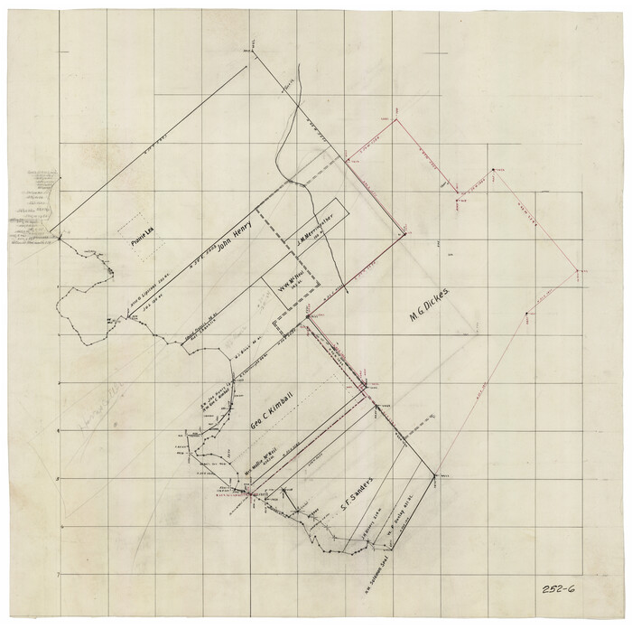
[Sketch of area around Geo. C. Kimball, M. G. Dickes, and S. F. Sanders surveys]
Print $20.00
- Digital $50.00
[Sketch of area around Geo. C. Kimball, M. G. Dickes, and S. F. Sanders surveys]
Size: 27.0 x 26.3 inches
92021
Map of Young County

Print $20.00
- Digital $50.00
Map of Young County
Size: 25.6 x 29.8 inches
92023

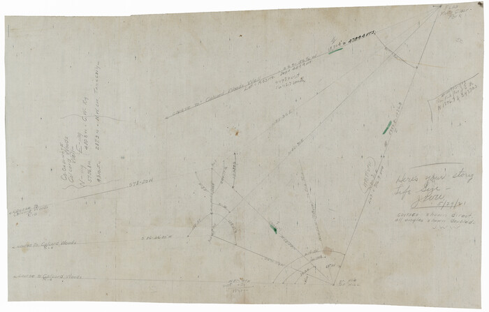
[Pencil sketch showing triangulation from Flag on Mouth of Clear Fork and Top Hill]
Print $20.00
- Digital $50.00
[Pencil sketch showing triangulation from Flag on Mouth of Clear Fork and Top Hill]
Size: 19.5 x 12.5 inches
92088
Map of Young County

Print $20.00
- Digital $50.00
Map of Young County
Size: 16.9 x 19.7 inches
92108
Foard County Sketch File 2
Print $40.00
- Digital $50.00
Foard County Sketch File 2
-
Size
23.8 x 16.3 inches
-
Map/Doc
11490
Palo Pinto County Sketch File 1
Print $20.00
- Digital $50.00
Palo Pinto County Sketch File 1
-
Size
18.8 x 23.5 inches
-
Map/Doc
12131
Stephens County Sketch File 1B
Print $20.00
- Digital $50.00
Stephens County Sketch File 1B
-
Size
12.9 x 28.2 inches
-
Map/Doc
12348
Young County Sketch File 10
Print $20.00
- Digital $50.00
Young County Sketch File 10
-
Size
14.1 x 17.7 inches
-
Map/Doc
12711
Young County Sketch File 17
Print $20.00
- Digital $50.00
Young County Sketch File 17
-
Size
18.5 x 24.3 inches
-
Map/Doc
12713
Jack County Sketch File 13
Print $4.00
- Digital $50.00
Jack County Sketch File 13
-
Size
10.3 x 8.0 inches
-
Map/Doc
27537
Young County Sketch File 6
Print $14.00
- Digital $50.00
Young County Sketch File 6
-
Size
13.0 x 8.2 inches
-
Map/Doc
40852
Young County Sketch File 19
Print $34.00
- Digital $50.00
Young County Sketch File 19
-
Size
14.5 x 8.9 inches
-
Map/Doc
40887
Young County Boundary File 1
Print $8.00
- Digital $50.00
Young County Boundary File 1
-
Size
10.3 x 8.2 inches
-
Map/Doc
60198
Young County Boundary File 2
Print $6.00
- Digital $50.00
Young County Boundary File 2
-
Size
14.2 x 8.7 inches
-
Map/Doc
60202
Young County Boundary File 98
Print $12.00
- Digital $50.00
Young County Boundary File 98
-
Size
8.8 x 7.5 inches
-
Map/Doc
60205
Young County Boundary File 98a
Print $32.00
- Digital $50.00
Young County Boundary File 98a
-
Size
10.2 x 8.0 inches
-
Map/Doc
60211
Map of the Recognised Line, M. El. P. & P. RR. from Texas & Arkansas State Line to Milam & Bexar Land District Line
Print $40.00
- Digital $50.00
Map of the Recognised Line, M. El. P. & P. RR. from Texas & Arkansas State Line to Milam & Bexar Land District Line
-
Size
15.3 x 89.4 inches
-
Map/Doc
64638
Young County Rolled Sketch 2
Print $20.00
- Digital $50.00
Young County Rolled Sketch 2
-
Size
26.2 x 25.0 inches
-
Map/Doc
8292
Young County Rolled Sketch 5
Print $20.00
- Digital $50.00
Young County Rolled Sketch 5
-
Size
20.2 x 26.1 inches
-
Map/Doc
8293
Young County Rolled Sketch 6
Print $20.00
- Digital $50.00
Young County Rolled Sketch 6
-
Size
43.4 x 30.8 inches
-
Map/Doc
8294
Young County Rolled Sketch 7
Print $20.00
- Digital $50.00
Young County Rolled Sketch 7
-
Size
37.3 x 26.4 inches
-
Map/Doc
8295
Young County Rolled Sketch 8
Print $20.00
- Digital $50.00
Young County Rolled Sketch 8
-
Size
40.5 x 25.8 inches
-
Map/Doc
8296
Young County Rolled Sketch 11
Print $20.00
- Digital $50.00
Young County Rolled Sketch 11
-
Size
14.9 x 23.1 inches
-
Map/Doc
8299
Young County Rolled Sketch 12
Print $20.00
- Digital $50.00
Young County Rolled Sketch 12
-
Size
24.2 x 17.9 inches
-
Map/Doc
8300
Young County Rolled Sketch 15
Print $20.00
- Digital $50.00
Young County Rolled Sketch 15
-
Size
18.0 x 22.7 inches
-
Map/Doc
8303
Map No. 3 by W. D. Twichell
Print $20.00
- Digital $50.00
Map No. 3 by W. D. Twichell
-
Size
42.5 x 32.9 inches
-
Map/Doc
89710
[River Meander along Jas. Tobin Survey and others]
Print $40.00
- Digital $50.00
[River Meander along Jas. Tobin Survey and others]
-
Size
73.6 x 43.9 inches
-
Map/Doc
89814
[Triangulation Sketch]
Print $40.00
- Digital $50.00
[Triangulation Sketch]
-
Size
56.0 x 38.0 inches
-
Map/Doc
89815
Plat of E. C. Stovall's Irrigated Plantation, Young Co., Texas
Print $20.00
- Digital $50.00
Plat of E. C. Stovall's Irrigated Plantation, Young Co., Texas
-
Size
17.6 x 14.7 inches
-
Map/Doc
92019
[Sketch of area around Geo. C. Kimball, M. G. Dickes, and S. F. Sanders surveys]
Print $20.00
- Digital $50.00
[Sketch of area around Geo. C. Kimball, M. G. Dickes, and S. F. Sanders surveys]
-
Size
27.0 x 26.3 inches
-
Map/Doc
92021
Map of Young County
Print $20.00
- Digital $50.00
Map of Young County
-
Size
25.6 x 29.8 inches
-
Map/Doc
92023
[Pencil sketch showing triangulation from Flag on Mouth of Clear Fork and Top Hill]
Print $20.00
- Digital $50.00
[Pencil sketch showing triangulation from Flag on Mouth of Clear Fork and Top Hill]
-
Size
19.5 x 12.5 inches
-
Map/Doc
92088
Map of Young County
Print $20.00
- Digital $50.00
Map of Young County
-
Size
16.9 x 19.7 inches
-
Map/Doc
92108