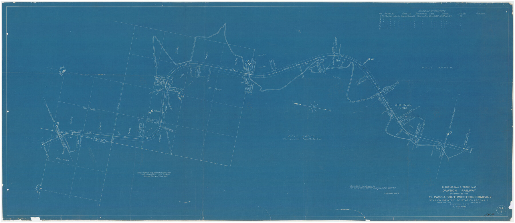
Right-of-way & Track Map Dawson Railway Operated by the El Paso & Southwestern Company Station 1021+79.7 to Station 1233+41.7
NM-14
-
Map/Doc
89661
-
Collection
Twichell Survey Records
-
Object Dates
6/30/[1910-1919] (Creation Date)
-
Counties
San Miguel [New Mexico]
-
Height x Width
57.0 x 25.1 inches
144.8 x 63.8 cm
-
Comments
Blueprint of Railroad R.O.W. Survey thru Bell Ranch
Part of: Twichell Survey Records
[H. & G. N. RR. Co. Block 1]
![90890, [H. & G. N. RR. Co. Block 1], Twichell Survey Records](https://historictexasmaps.com/wmedia_w700/maps/90890-1.tif.jpg)
Print $20.00
- Digital $50.00
[H. & G. N. RR. Co. Block 1]
Size 17.1 x 28.0 inches
Map/Doc 90890
[H. & T. C. Block 47 and vicinity]
![91171, [H. & T. C. Block 47 and vicinity], Twichell Survey Records](https://historictexasmaps.com/wmedia_w700/maps/91171-1.tif.jpg)
Print $20.00
- Digital $50.00
[H. & T. C. Block 47 and vicinity]
1891
Size 19.4 x 15.3 inches
Map/Doc 91171
[Surveys Adjacent to W. D. Twichell's near Palo Pinto Creek]
![92101, [Surveys Adjacent to W. D. Twichell's near Palo Pinto Creek], Twichell Survey Records](https://historictexasmaps.com/wmedia_w700/maps/92101-1.tif.jpg)
Print $2.00
- Digital $50.00
[Surveys Adjacent to W. D. Twichell's near Palo Pinto Creek]
Size 8.4 x 6.6 inches
Map/Doc 92101
A true copy of Peck's field book page 1, except classification of lands

Print $2.00
- Digital $50.00
A true copy of Peck's field book page 1, except classification of lands
1876
Size 5.3 x 12.0 inches
Map/Doc 91979
Plat Showing Survey made in Block A-25 Public School Land, Gaines County, Texas

Print $20.00
- Digital $50.00
Plat Showing Survey made in Block A-25 Public School Land, Gaines County, Texas
Size 35.7 x 30.3 inches
Map/Doc 92656
![90567, [Block M], Twichell Survey Records](https://historictexasmaps.com/wmedia_w700/maps/90567-1.tif.jpg)
Sketch Showing Construction of School Leagues and Adjacent Lands Situated in Martin and Dawson Counties

Print $40.00
- Digital $50.00
Sketch Showing Construction of School Leagues and Adjacent Lands Situated in Martin and Dawson Counties
1914
Size 39.3 x 97.6 inches
Map/Doc 93201
Northeastern Half of Pecos County - Ownership Map

Print $40.00
- Digital $50.00
Northeastern Half of Pecos County - Ownership Map
Size 92.7 x 37.2 inches
Map/Doc 93197
Plat of Green Valley Ranch

Print $20.00
- Digital $50.00
Plat of Green Valley Ranch
Size 14.4 x 23.2 inches
Map/Doc 92909
![91800, [Block M-19], Twichell Survey Records](https://historictexasmaps.com/wmedia_w700/maps/91800-1.tif.jpg)
Ownership Map of Lynn County

Print $20.00
- Digital $50.00
Ownership Map of Lynn County
Size 34.5 x 36.1 inches
Map/Doc 92900
Map Showing Soash Lands in Castro, Lamb, and Hale Counties, Texas

Print $20.00
- Digital $50.00
Map Showing Soash Lands in Castro, Lamb, and Hale Counties, Texas
1907
Size 13.9 x 17.6 inches
Map/Doc 91000
You may also like
Montgomery County Working Sketch 23

Print $20.00
- Digital $50.00
Montgomery County Working Sketch 23
1937
Size 42.5 x 37.2 inches
Map/Doc 71130
Map of Jefferson County

Print $20.00
- Digital $50.00
Map of Jefferson County
1896
Size 25.3 x 21.6 inches
Map/Doc 3731
Zapata County Working Sketch 13

Print $20.00
- Digital $50.00
Zapata County Working Sketch 13
1962
Size 28.7 x 29.6 inches
Map/Doc 62064
Hopkins County Sketch File 10a

Print $4.00
- Digital $50.00
Hopkins County Sketch File 10a
1856
Size 12.2 x 7.8 inches
Map/Doc 26702
The Judicial District/County of Lavaca. Abolished, Spring 1842

Print $20.00
The Judicial District/County of Lavaca. Abolished, Spring 1842
2020
Size 14.6 x 21.7 inches
Map/Doc 96332
Leon County Rolled Sketch 31A

Print $20.00
- Digital $50.00
Leon County Rolled Sketch 31A
1995
Size 38.9 x 15.4 inches
Map/Doc 6615
Val Verde County Sketch File DD and DD1

Print $64.00
- Digital $50.00
Val Verde County Sketch File DD and DD1
1889
Size 8.9 x 7.9 inches
Map/Doc 39067
Map of Block 1, H. & G. N. RR. Co.

Print $20.00
- Digital $50.00
Map of Block 1, H. & G. N. RR. Co.
1908
Size 26.3 x 32.0 inches
Map/Doc 90899

St. Louis, Brownsville & Mexico Railway Location Map from Mile 0 to Mile 20

Print $40.00
- Digital $50.00
St. Louis, Brownsville & Mexico Railway Location Map from Mile 0 to Mile 20
1906
Size 19.5 x 74.5 inches
Map/Doc 64075
Outer Continental Shelf Leasing Maps (Texas Offshore Operations)

Print $20.00
- Digital $50.00
Outer Continental Shelf Leasing Maps (Texas Offshore Operations)
Size 12.7 x 15.2 inches
Map/Doc 76169
Briscoe County Sketch File 11

Print $9.00
- Digital $50.00
Briscoe County Sketch File 11
Size 11.8 x 11.0 inches
Map/Doc 16422