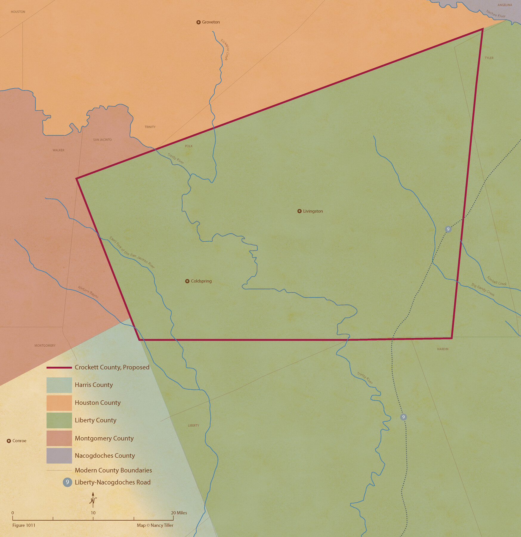
From Citizens of Liberty County for the Creation a New County to be Called Crockett, November 12, 1838
Figure No. 1011 from 'A Boundary Atlas of Texas, 1821-1845' by Jim Tiller
-
Map/Doc
96385
-
Collection
Nancy and Jim Tiller Digital Collection
-
Object Dates
2020/1/1 (Creation Date)
-
People and Organizations
Jim Tiller (Author)
Nancy Tiller (Cartographer)
Gang Gong (GIS Professional)
-
Subjects
Atlas Republic of Texas Texas Boundaries
-
Height x Width
22.3 x 21.7 inches
56.6 x 55.1 cm
-
Medium
digital image
-
Comments
To purchase a digital PDF copy of "A Boundary Atlas of Texas, 1821-1845" see 96437.
Part of: Nancy and Jim Tiller Digital Collection
The Mexican Department of Nacogdoches. Created, January 31, 1831

Print $20.00
The Mexican Department of Nacogdoches. Created, January 31, 1831
2020
Size 18.4 x 21.7 inches
Map/Doc 95972
From Citizens to Redefine the Boundary Between Gonzales and Victoria Counties, April 14, 18

Print $20.00
From Citizens to Redefine the Boundary Between Gonzales and Victoria Counties, April 14, 18
2020
Size 24.9 x 21.7 inches
Map/Doc 96378
From Citizens of Nacogdoches County for the Creation of a New County to be Called Smith, September 4, 1841

Print $20.00
From Citizens of Nacogdoches County for the Creation of a New County to be Called Smith, September 4, 1841
2020
Size 18.3 x 21.7 inches
Map/Doc 96392
The Mexican Municipality of Matagorda. Created, March 6, 1834

Print $20.00
The Mexican Municipality of Matagorda. Created, March 6, 1834
2020
Size 15.9 x 21.7 inches
Map/Doc 96025
The Republic County of Milam. January 15, 1842

Print $20.00
The Republic County of Milam. January 15, 1842
2020
Size 17.4 x 21.6 inches
Map/Doc 96230
The Republic County of Bowie. January 8, 1844

Print $20.00
The Republic County of Bowie. January 8, 1844
2020
Size 19.5 x 21.7 inches
Map/Doc 96107
The Chief Justice County of Gonzales. Lands in Conflict with Victoria County

Print $20.00
The Chief Justice County of Gonzales. Lands in Conflict with Victoria County
2020
Size 22.3 x 21.7 inches
Map/Doc 96048
The Republic County of Jackson. Spring 1842

Print $20.00
The Republic County of Jackson. Spring 1842
2020
Size 15.6 x 21.8 inches
Map/Doc 96190
The Judicial District/County of Ward. Created, January 19, 1841

Print $20.00
The Judicial District/County of Ward. Created, January 19, 1841
2020
Size 18.7 x 21.7 inches
Map/Doc 96354
The Republic County of Shelby. January 16, 1843

Print $20.00
The Republic County of Shelby. January 16, 1843
2020
Size 20.0 x 21.7 inches
Map/Doc 96285
McMullen and McGloin Empresario Colony. August 16, 1828

Print $20.00
McMullen and McGloin Empresario Colony. August 16, 1828
2020
Size 17.6 x 21.7 inches
Map/Doc 95998
The Mexican Municipality of Austin. Proposed, No Date

Print $20.00
The Mexican Municipality of Austin. Proposed, No Date
2020
Size 17.0 x 21.7 inches
Map/Doc 96014
You may also like
Aransas County Sketch File 18

Print $8.00
- Digital $50.00
Aransas County Sketch File 18
1888
Size 12.7 x 8.2 inches
Map/Doc 13149
Right of Way and Track Map, International & Gt. Northern Ry. Operated by the International & Gt. Northern Ry. Co., Gulf Division

Print $40.00
- Digital $50.00
Right of Way and Track Map, International & Gt. Northern Ry. Operated by the International & Gt. Northern Ry. Co., Gulf Division
1917
Size 25.1 x 56.7 inches
Map/Doc 64246
Working Sketch Reeves County [showing Blocks 70-72, C-8, 9, 17-18, and Texas & Pacific RR Block 58]
![91770, Working Sketch Reeves County [showing Blocks 70-72, C-8, 9, 17-18, and Texas & Pacific RR Block 58], Twichell Survey Records](https://historictexasmaps.com/wmedia_w700/maps/91770-1.tif.jpg)
Print $20.00
- Digital $50.00
Working Sketch Reeves County [showing Blocks 70-72, C-8, 9, 17-18, and Texas & Pacific RR Block 58]
1908
Size 21.6 x 17.2 inches
Map/Doc 91770
Harris County Rolled Sketch T1

Print $20.00
- Digital $50.00
Harris County Rolled Sketch T1
1916
Size 29.8 x 24.3 inches
Map/Doc 6144
Matagorda County

Print $20.00
- Digital $50.00
Matagorda County
1896
Size 32.7 x 30.5 inches
Map/Doc 5082
Milam County Sketch File 5

Print $4.00
- Digital $50.00
Milam County Sketch File 5
1901
Size 14.2 x 8.7 inches
Map/Doc 31632
No. 3 Chart of Channel connecting Corpus Christi Bay with Aransas Bay, Texas

Print $20.00
- Digital $50.00
No. 3 Chart of Channel connecting Corpus Christi Bay with Aransas Bay, Texas
1878
Size 18.3 x 27.5 inches
Map/Doc 72784
Grimes County Working Sketch 5

Print $40.00
- Digital $50.00
Grimes County Working Sketch 5
1949
Size 43.6 x 83.2 inches
Map/Doc 63296
Flight Mission No. DCL-7C, Frame 14, Kenedy County

Print $20.00
- Digital $50.00
Flight Mission No. DCL-7C, Frame 14, Kenedy County
1943
Size 15.3 x 15.2 inches
Map/Doc 86006

Liberty County Working Sketch 59

Print $40.00
- Digital $50.00
Liberty County Working Sketch 59
1968
Size 38.1 x 87.1 inches
Map/Doc 70519
Falls County Sketch File 33

Print $4.00
- Digital $50.00
Falls County Sketch File 33
1873
Size 10.3 x 8.3 inches
Map/Doc 22441