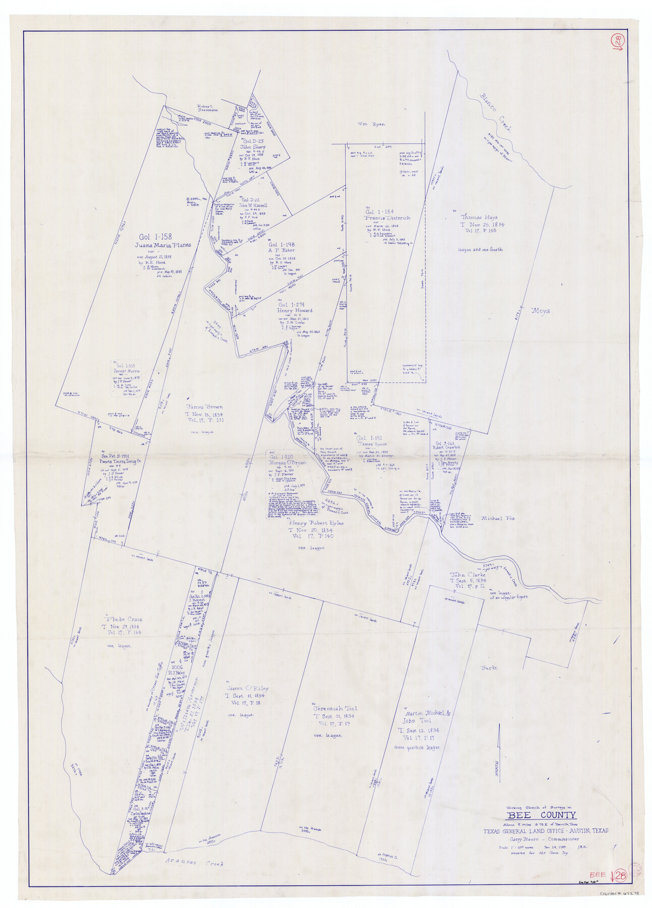
Bee County Working Sketch 28
-
Map/Doc
67278
-
Collection
General Map Collection
-
Object Dates
1/14/1988 (Creation Date)
-
People and Organizations
Joan Kilpatrick (Draftsman)
Garry Mauro (GLO Commissioner)
-
Counties
Bee
-
Subjects
Surveying Working Sketch
-
Height x Width
48.2 x 34.6 inches
122.4 x 87.9 cm
-
Scale
1" = 600 varas
-
Comments
Surveys located about eight miles South 75 degrees East of Beeville, Texas.
Part of: General Map Collection
[Sketch for Mineral Application 33721 - 33725 Incl. - Padre and Mustang Island]
![2869, [Sketch for Mineral Application 33721 - 33725 Incl. - Padre and Mustang Island], General Map Collection](https://historictexasmaps.com/wmedia_w700/maps/2869.tif.jpg)
Print $20.00
- Digital $50.00
[Sketch for Mineral Application 33721 - 33725 Incl. - Padre and Mustang Island]
1942
Size 22.2 x 22.3 inches
Map/Doc 2869
Shackelford County Working Sketch 5

Print $20.00
- Digital $50.00
Shackelford County Working Sketch 5
1936
Size 22.5 x 31.6 inches
Map/Doc 63845
[Right of Way Map, Belton Branch of the M.K.&T. RR.]
![64227, [Right of Way Map, Belton Branch of the M.K.&T. RR.], General Map Collection](https://historictexasmaps.com/wmedia_w700/maps/64227.tif.jpg)
Print $20.00
- Digital $50.00
[Right of Way Map, Belton Branch of the M.K.&T. RR.]
1896
Size 22.0 x 7.2 inches
Map/Doc 64227
Upton County Rolled Sketch 51

Print $20.00
- Digital $50.00
Upton County Rolled Sketch 51
1961
Size 34.0 x 29.8 inches
Map/Doc 8086
Flight Mission No. BRE-5P, Frame 199, Nueces County

Print $20.00
- Digital $50.00
Flight Mission No. BRE-5P, Frame 199, Nueces County
1956
Size 18.4 x 22.3 inches
Map/Doc 86839
Brewster County Working Sketch 89

Print $20.00
- Digital $50.00
Brewster County Working Sketch 89
1974
Size 20.5 x 44.1 inches
Map/Doc 67689
Flight Mission No. DQN-5K, Frame 29, Calhoun County

Print $20.00
- Digital $50.00
Flight Mission No. DQN-5K, Frame 29, Calhoun County
1953
Size 18.5 x 22.3 inches
Map/Doc 84380
Live Oak County Sketch File 27

Print $4.00
- Digital $50.00
Live Oak County Sketch File 27
1922
Size 14.3 x 8.7 inches
Map/Doc 30312
Hudspeth County Working Sketch 23

Print $40.00
- Digital $50.00
Hudspeth County Working Sketch 23
1967
Size 52.6 x 39.2 inches
Map/Doc 66305
No. IX - Outline map of the vicinity of Corpus Christi

Print $20.00
- Digital $50.00
No. IX - Outline map of the vicinity of Corpus Christi
Size 24.9 x 18.2 inches
Map/Doc 72966
Nueces County Sketch File 73

Print $4.00
- Digital $50.00
Nueces County Sketch File 73
1991
Size 11.1 x 8.8 inches
Map/Doc 33026
Walker County Miscellaneous Sketch 1

Print $20.00
- Digital $50.00
Walker County Miscellaneous Sketch 1
2003
Size 36.0 x 31.3 inches
Map/Doc 88868
You may also like
Val Verde County Sketch File F

Print $42.00
- Digital $50.00
Val Verde County Sketch File F
1906
Size 40.1 x 16.9 inches
Map/Doc 10423
Terrell County Working Sketch 62

Print $20.00
- Digital $50.00
Terrell County Working Sketch 62
1963
Size 32.2 x 34.4 inches
Map/Doc 69583
Pecos County Rolled Sketch 44A

Print $20.00
- Digital $50.00
Pecos County Rolled Sketch 44A
1912
Size 19.7 x 34.6 inches
Map/Doc 7223
Andrews County

Print $40.00
- Digital $50.00
Andrews County
1951
Size 42.7 x 54.5 inches
Map/Doc 1769
Houston County Sketch File 7a

Print $4.00
- Digital $50.00
Houston County Sketch File 7a
Size 7.6 x 8.2 inches
Map/Doc 26766
Crane County Working Sketch 11

Print $20.00
- Digital $50.00
Crane County Working Sketch 11
1941
Size 18.8 x 18.4 inches
Map/Doc 68288
Potter County Rolled Sketch 13

Print $20.00
- Digital $50.00
Potter County Rolled Sketch 13
2004
Size 18.7 x 23.2 inches
Map/Doc 82477
Revised Map of MacDade, Bastrop County, Texas

Print $20.00
- Digital $50.00
Revised Map of MacDade, Bastrop County, Texas
Size 26.6 x 18.4 inches
Map/Doc 78478
Galveston County Sketch File 51

Print $20.00
- Digital $50.00
Galveston County Sketch File 51
1895
Size 25.7 x 40.2 inches
Map/Doc 10457
Map of Llano County Showing Geology, Mineral Localities, Topography, etc.

Print $20.00
Map of Llano County Showing Geology, Mineral Localities, Topography, etc.
1875
Size 16.5 x 21.3 inches
Map/Doc 88969
Duval County Rolled Sketch 20

Print $20.00
- Digital $50.00
Duval County Rolled Sketch 20
Size 33.2 x 42.0 inches
Map/Doc 8811
Hidalgo County Sketch File 8

Print $4.00
- Digital $50.00
Hidalgo County Sketch File 8
1890
Size 14.1 x 8.6 inches
Map/Doc 26407