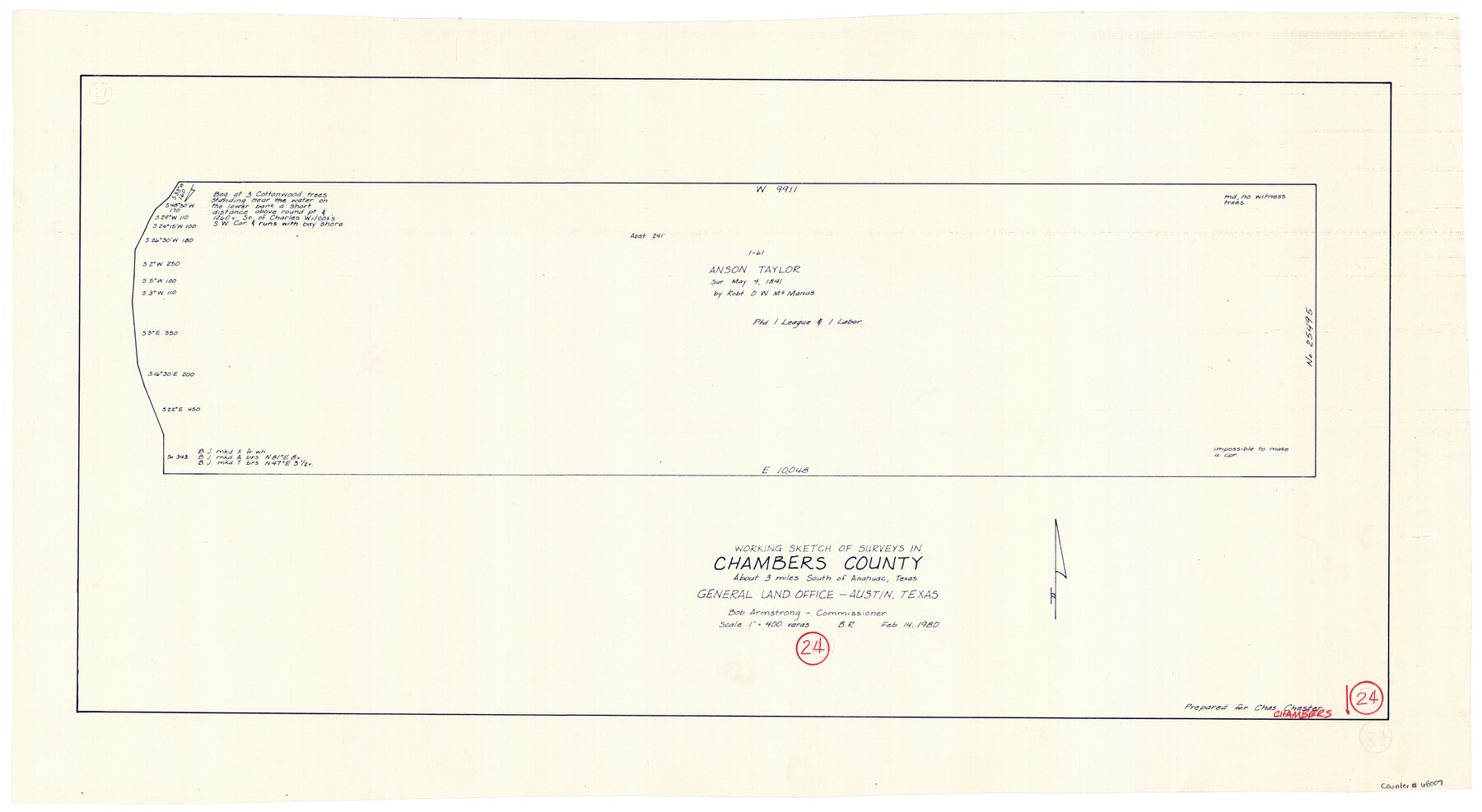
Chambers County Working Sketch 24
-
Map/Doc
68007
-
Collection
General Map Collection
-
Object Dates
2/14/1980 (Creation Date)
-
People and Organizations
Beverly Robison (Draftsman)
-
Counties
Chambers
-
Subjects
Surveying Working Sketch
-
Height x Width
17.5 x 32.3 inches
44.5 x 82.0 cm
-
Scale
1" = 400 varas
Part of: General Map Collection
Upton County Sketch File 24

Print $4.00
- Digital $50.00
Upton County Sketch File 24
1928
Size 11.3 x 8.8 inches
Map/Doc 38879
Harris County Rolled Sketch 101

Print $20.00
- Digital $50.00
Harris County Rolled Sketch 101
2004
Size 24.3 x 36.2 inches
Map/Doc 83063
Jeff Davis County Rolled Sketch 6

Print $20.00
- Digital $50.00
Jeff Davis County Rolled Sketch 6
1889
Size 41.3 x 26.4 inches
Map/Doc 6360
Flight Mission No. BQR-5K, Frame 73, Brazoria County

Print $20.00
- Digital $50.00
Flight Mission No. BQR-5K, Frame 73, Brazoria County
1952
Size 19.1 x 22.6 inches
Map/Doc 84018
Polk County Boundary File 70a

Print $40.00
- Digital $50.00
Polk County Boundary File 70a
Size 18.1 x 23.4 inches
Map/Doc 57935
Sutton County Working Sketch 9

Print $20.00
- Digital $50.00
Sutton County Working Sketch 9
1972
Size 41.8 x 38.1 inches
Map/Doc 62352
Map of Valley of Red River in Texas, Oklahoma, and Arkansas between Meridians 96 deg. 30 min. and 98 deg. West Longitude

Print $40.00
- Digital $50.00
Map of Valley of Red River in Texas, Oklahoma, and Arkansas between Meridians 96 deg. 30 min. and 98 deg. West Longitude
1920
Size 31.0 x 91.7 inches
Map/Doc 75252
Loving County

Print $20.00
- Digital $50.00
Loving County
1932
Size 35.0 x 45.6 inches
Map/Doc 73225
Callahan County Working Sketch 4

Print $20.00
- Digital $50.00
Callahan County Working Sketch 4
1953
Size 17.1 x 27.0 inches
Map/Doc 67886

Right of Way and Track Map Texas & New Orleans R.R. Co. operated by the T. & N. O. R.R. Co. Dallas-Sabine Branch

Print $40.00
- Digital $50.00
Right of Way and Track Map Texas & New Orleans R.R. Co. operated by the T. & N. O. R.R. Co. Dallas-Sabine Branch
1918
Size 26.8 x 56.7 inches
Map/Doc 64151
Eastland County Working Sketch 29

Print $20.00
- Digital $50.00
Eastland County Working Sketch 29
1952
Size 21.1 x 22.3 inches
Map/Doc 68810
You may also like
A Little Journey through the Lower Valley of the Rio Grande - The Magic Valley of Texas

A Little Journey through the Lower Valley of the Rio Grande - The Magic Valley of Texas
1928
Map/Doc 96741
Bandera County Working Sketch 32

Print $20.00
- Digital $50.00
Bandera County Working Sketch 32
1956
Size 22.7 x 18.4 inches
Map/Doc 67628

Township No. 1 North Range No. 27 West Indian Meridian

Print $20.00
- Digital $50.00
Township No. 1 North Range No. 27 West Indian Meridian
1875
Size 19.3 x 24.6 inches
Map/Doc 75170
Runnels County

Print $20.00
- Digital $50.00
Runnels County
1879
Size 22.1 x 19.2 inches
Map/Doc 3999
Taylor County Sketch File 20

Print $20.00
- Digital $50.00
Taylor County Sketch File 20
1950
Size 32.1 x 46.1 inches
Map/Doc 10385
Scurry County Working Sketch 5

Print $40.00
- Digital $50.00
Scurry County Working Sketch 5
1950
Size 72.5 x 27.8 inches
Map/Doc 63834
Sketch of the route taken by a scouting party from Phantom Hill to Double Mountain, Texas

Print $20.00
- Digital $50.00
Sketch of the route taken by a scouting party from Phantom Hill to Double Mountain, Texas
1852
Size 25.3 x 13.4 inches
Map/Doc 2006

[E. L. & R. R. Block E, Showing Mound Lake]
![91335, [E. L. & R. R. Block E, Showing Mound Lake], Twichell Survey Records](https://historictexasmaps.com/wmedia_w700/maps/91335-1.tif.jpg)
Print $2.00
- Digital $50.00
[E. L. & R. R. Block E, Showing Mound Lake]
Size 14.8 x 6.3 inches
Map/Doc 91335
[Surveys in the Jefferson District]
![275, [Surveys in the Jefferson District], General Map Collection](https://historictexasmaps.com/wmedia_w700/maps/275.tif.jpg)
Print $2.00
- Digital $50.00
[Surveys in the Jefferson District]
1841
Size 8.3 x 8.0 inches
Map/Doc 275
Spence Addition Owned by L.N. Goldbeck and Herman Pressler - A Subdivision of Outlot 43, Division "O"

Print $20.00
- Digital $50.00
Spence Addition Owned by L.N. Goldbeck and Herman Pressler - A Subdivision of Outlot 43, Division "O"
1913
Size 15.4 x 12.8 inches
Map/Doc 632